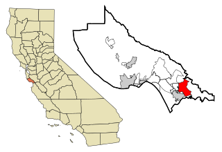
Interlaken is a census-designated place (CDP) in Santa Cruz County, California, United States. The population was 7,368 at the 2020 census.
Forest Lake is an unincorporated community and census-designated place (CDP) in Ela Township of Lake County, Illinois, United States. It is about 35 miles (56 km) northwest of downtown Chicago. Per the 2020 census, the population was 1,784. The community was founded in 1935 as a vacation community for Chicago residents.
Fox Lake Hills is an unincorporated community and census-designated place (CDP) in Lake Villa Township, Lake County, Illinois, United States. Per the 2020 census, the population was 2,684.

South Gull Lake is a census-designated place (CDP) in Ross Township, Kalamazoo County, in the U.S. state of Michigan. It includes the unincorporated communities of Yorkville, Gull Lake, and Midland Park and does not have any legal status as an incorporated municipality. The population of the CDP was 1,182 at the 2010 census, down from 1,526 at the 2000 census.

Castle Point is an unincorporated community and census-designated place (CDP) in St. Louis County, Missouri, United States. The population was 3,962 at the 2010 census.

Cedar Glen Lakes is an unincorporated community and census-designated place (CDP) located within Manchester Township, in Ocean County, in the U.S. state of New Jersey. As of the 2010 United States Census, the CDP's population was 1,421.

Saugerties South is a hamlet in Ulster County, New York, United States. The population was 2,442 at the 2020 census.
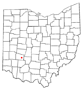
Shawnee Hills is a census-designated place (CDP) in Greene County, Ohio, United States. Shawnee Hills consists of a planned community centered on the 250-acre (1.0 km2) Shawnee Lake. The population was 2,230 at the 2020 census. It is part of the Dayton Metropolitan Statistical Area, and should not be confused with the incorporated village of Shawnee Hills in Delaware County.

Canadohta Lake is a census-designated place (CDP) in Crawford County, Pennsylvania, United States. The population was 503 at the 2020 census.

Lake Wynonah is a census-designated place (CDP) in Schuylkill County, Pennsylvania, United States. The population was 1,961 at the 2000 census, and 2,640 at the 2010 census. Lake Wynonah is a gated community with two lakes, Fawn Lake and Lake Wynonah, and as of July 2008, there are over 1200 homes and 1500 members. It is in South Manheim and Wayne Townships.

Winnsboro Mills is an unincorporated community and census-designated place (CDP) in Fairfield County, South Carolina, United States. The population was 1,898 at the 2010 census, down from 2,263 at the 2000 census. It is part of the Columbia, South Carolina Metropolitan Statistical Area.

Millwood is a census-designated place (CDP) in Sumter County, South Carolina, United States. The population was 885 at the 2000 census. It is included in the Sumter, South Carolina Metropolitan Statistical Area.

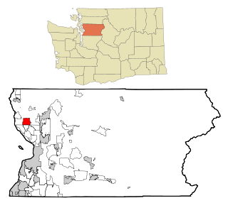
Lake Bosworth is a census-designated place (CDP) in Snohomish County, Washington, United States. The population was 868 at the 2020 census, up from 667 at the 2010 census.
Lake Goodwin is a former census-designated place (CDP) in Snohomish County, Washington, United States. The population was 3,354 at the 2000 census. The CDP was discontinued at the 2010 census.

Wind Lake is a census-designated place (CDP) in Racine County, Wisconsin, United States. The population was 5,355 at the 2020 census. Wind Lake is in the town of Norway.

Little Round Lake is a census-designated place (CDP) in the town of Bass Lake, Sawyer County, Wisconsin, United States. The population was 1,081 at the 2010 census. It is the largest community on the reservation of the federally recognized tribe of the Lac Courte Oreilles Band of Lake Superior Chippewa Indians.

Potter Lake is a census-designated place (CDP) in the town of East Troy, Walworth County, Wisconsin, United States. The population was 1,117 at the 2020 census.

Lake Wisconsin is a census-designated place (CDP) in Columbia and Sauk counties, in the towns of Lodi and Merrimac, in Wisconsin, United States. The population was 4,189 at the 2010 census.

Lenox, also known as Lenox Center, is a census-designated place (CDP) in the town of Lenox in Berkshire County, Massachusetts, United States. The population was 1,675 at the 2010 census, out of 5,025 in the entire town of Lenox.

Clearbrook is a gated community and census-designated place (CDP) located in Monroe Township, Middlesex County, in the U.S. state of New Jersey. It is in the western part of the township, bordered to the north by Encore at Monroe and to the east by Concordia and The Ponds. It is 3.5 miles (5.6 km) southwest of Jamesburg and 5 miles (8 km) northeast of Hightstown.

