Silver Firs, Washington

Last updated

Silver Firs, Washington
CDP
Silver firs boundary far.svg
Location of Silver Firs, Washington
Silver firs boundary (2).svg
Coordinates: 47°51′42″N122°08′44″W / 47.86167°N 122.14556°W / 47.86167; -122.14556
CountryUnited States
State Washington
County Snohomish
Area
  Total14.0 sq mi (36.2 km2)
  Land14.0 sq mi (36.1 km2)
  Water0.0 sq mi (0.1 km2)
Population
 (2020)
  Total22,174 [1]
  Density2,686.2/sq mi (1,037.1/km2)
Time zone UTC-8 (Pacific (PST))
  Summer (DST) UTC-7 (PDT)
FIPS code 53-63052 [2]

Silver Firs is a census-designated place (CDP) in Snohomish County, Washington, United States. The population was 22,174 [1] at the 2020 census. It lies northeast of the city of Mill Creek. Silver Firs is one of two CDPs that were created out of the former Seattle Hill-Silver Firs CDP in 2010, the other being Eastmont. [3]

Contents

Geography

Silver Firs is located at 47°51′42″N122°08′44″W / 47.86167°N 122.14556°W / 47.86167; -122.14556 (47.881010, -122.178697). [4]

According to the United States Census Bureau, the CDP has a total area of 14.0 square miles (36.2 km2), of which, 13.9 square miles (36.1 km2) of it is land and 0.04 square miles (0.1 km2) of it (0.21%) is water.

The CDP contains several large residential neighborhoods, including Silver Firs and the Highlands.

Demographics

Historical population
CensusPop.Note
2010 20,891
2020 22,1746.1%
source: [5] [1]

As of the census [1] of 2020, there were 22,174 people residing in the CDP. The racial makeup [6] of the CDP was 68.22% White, 2.19% African American, 0.46% Native American, 15.75% Asian, 0.28% Pacific Islander, 2.52% from other races, and 10.57% from two or more races.

The ACS 5-Year Estimate of 2021 for Housing and Families [7] estimated that the population consisted of 7,384 households, and 6,061 families. 94.6% of these housing units consisted of 1-unit structures, with 90.1% of units being owner-occupied. It was estimated that 43.6% of households had children under the age of 18 living with them, 69.2% were married couples living together, 9.1% had a female householder with no husband present, and 17.9% were non-families. 44.7% of all households were estimated to have one or more people under 18 years of age, and 3.7% had someone living alone who was 65 years of age or older. The average household size was 2.99 and the average family size was 3.22.

The ACS 5-Year Estimate of 2021 for Age and Sex [8] reported the age distribution as 25.2% under the age of 18, 7.8% from 18 to 24, 39.3% from 15 to 44, 14.13% who were 60 years of age or older, and 2.5% who were 75 years of age or older. The median age was 37.6 years overall, or 36.5 years for males and 39.3 years for females. For every 100 females, there were 108.5 males.

The ACS 5-Year Estimate of 2021 for Commuting Characteristics [9] reported that 75.3% of residents in the CDP commuted to work via car, truck or van (with 69.0% of residents driving alone and 6.3% carpooling). 5.1% of residents were estimated to commute via public transportation, and 17.2% were estimated to work from home.

The ACS 5-Year Estimate of 2021 for Medium Income [10] reported a median income for a household in the CDP as $137,577, and the median income for a family was $145,973. In nonfamily households, Males living alone were estimated to have a median income of $89,006, with a median income of $109,000 for all males (with a margin of error of $44,711). Females living alone were estimated to have a median income of $73,750, with a median income of $81,581 for all females (with a margin of error of $15,914).

Further ACS 5-Year Estimate data for 2021 includes:

Related Research Articles

<span class="mw-page-title-main">Covelo, California</span> Census-designated place in California, United States

Covelo is a census-designated place (CDP) in Mendocino County, California, United States. Covelo is located 14 miles (23 km) east-northeast of Laytonville, at an elevation of 1,398 feet (426 m). The population was 1,394 at the 2020 census, up from 1,255 at the 2010 census. 405 acres (1.64 km2) of Covelo is part of the Round Valley Indian Reservation.

<span class="mw-page-title-main">Richmond Heights, Florida</span> Census-designated place in Florida, United States

Richmond Heights is a census-designated place (CDP) in Miami-Dade County, Florida, United States. The population was 8,944 at the 2020 census.

<span class="mw-page-title-main">West Little River, Florida</span> CDP in Miami-Dade County, Florida, US

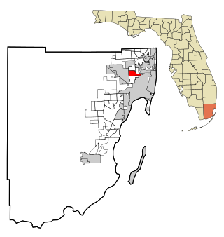
West Little River is a census-designated place (CDP) in Miami-Dade County, Florida, United States. The population was 34,128 at the 2020 census.

<span class="mw-page-title-main">Severn, Maryland</span> Census-designated place in Maryland, United States

Severn is a census-designated place (CDP) in Anne Arundel County, Maryland, United States. According to the 2020 U.S. census, the population of Severn is 57,118, a 22.6% increase from 44,231 in 2010. The zip code is 21144.

<span class="mw-page-title-main">Potomac, Maryland</span> Census-designated place in Maryland, United States

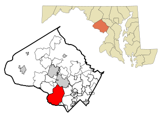
Potomac is an unincorporated community and census-designated place (CDP) in Montgomery County, Maryland. As of the 2020 census, it had a population of 47,018. It is named after the nearby Potomac River.

<span class="mw-page-title-main">Redwater, Mississippi</span> Census-designated place in Mississippi, United States

Redwater is a census-designated place (CDP) in Leake County, Mississippi, United States. It is one of the eight communities of the Mississippi Band of Choctaw Indians Reservation, and the population is 61% Choctaw. The population was 633 at the 2010 census, up from 409 at the 2000 census.

<span class="mw-page-title-main">Silver Ridge, New Jersey</span> Populated place in Ocean County, New Jersey, US

Silver Ridge is an unincorporated community and census-designated place (CDP) located within Berkeley Township, in Ocean County, in the U.S. state of New Jersey. As of the 2010 United States Census, the CDP's population was 1,133.

<span class="mw-page-title-main">Waretown, New Jersey</span> Populated place in Ocean County, New Jersey, US

Waretown is an unincorporated community and census-designated place (CDP) located on the Jersey Shore within Ocean Township, in Ocean County, in the U.S. state of New Jersey. As of the 2020 United States census, the CDP's population was 1,483, a decrease of 86 (5.5%) from the 1,589 recorded at the 2010 United States Census, which in turn had decreased by 13 (-0.8%) from the 1,582 counted at the 2000 census. Waretown is home to Albert Music Hall.

<span class="mw-page-title-main">Manorville, New York</span> Hamlet and census-designated place in New York, United States

Manorville is a hamlet and census-designated place (CDP) in Suffolk County, New York, United States. The population was 14,314 at the 2010 census.

<span class="mw-page-title-main">Buies Creek, North Carolina</span> Census-designated place in North Carolina, United States

Buies Creek is a census-designated place (CDP) located in the Neills Creek Township of Harnett County, North Carolina, United States. It is the home of Campbell University. The population was 3,253 at the 2020 census, up from 2,942 in 2010. Buies Creek is a part of the Dunn Micropolitan Area, which is also a part of the greater Raleigh–Durham–Cary Combined Statistical Area (CSA) as defined by the United States Census Bureau.

<span class="mw-page-title-main">White City, Utah</span> Metro Township in Utah, United States

White City is a metro township in Salt Lake County, Utah, United States. The township is an enclave of the City of Sandy. The population was 5,407 at the 2010 census, a modest decrease from the 2000 population of 5,988.

<span class="mw-page-title-main">Bethel (CDP), Connecticut</span> Census-designated place in Connecticut, United States

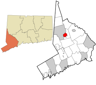
Bethel is a census-designated place (CDP) in Fairfield County, Connecticut, United States. It comprises the primary village and surrounding residential land within the town of Bethel. As of the 2010 census, the population of the CDP was 9,549, out of 18,584 in the entire town.

<span class="mw-page-title-main">Ridgefield (CDP), Connecticut</span> Census-designated place in Connecticut, United States

Ridgefield is a census-designated place (CDP) in Fairfield County, Connecticut, United States. It consists of the primary central village in the town of Ridgefield and surrounding residential areas. As of the 2010 census, the population of the CDP was 7,645, out of 24,638 in the entire town.

Dallas is the ninth-most populous city in the U.S. and third in Texas after Houston and San Antonio. At the 2010 U.S. census, Dallas had a population of 1,197,816. In July 2018, the population estimate of the city of Dallas was 1,345,076, an increase of 147,260 since the 2010 United States Census.

<span class="mw-page-title-main">Gouldsboro, Pennsylvania</span> Village in Pennsylvania, United States

Gouldsboro is a village and census-designated place (CDP) in Lehigh Township in Wayne County, and Coolbaugh Township, in Monroe County, Pennsylvania, United States. The CDP's population was 750 at time of the 2020 United States Census.

<span class="mw-page-title-main">Oxford (CDP), New Jersey</span> Populated place in Warren County, New Jersey, US

Oxford is an unincorporated community and census-designated place (CDP) located within Oxford Township in Warren County, New Jersey, United States, that was created as part of the 2010 United States Census. As of the 2010 Census, the CDP's population was 1,090.

<span class="mw-page-title-main">Pocono Springs, Pennsylvania</span> Place in Pennsylvania, United States

Pocono Springs is a private community and census-designated place (CDP) in Lehigh and Sterling Townships in Wayne County, Pennsylvania, United States. The CDP's population was 926 at the time of the 2010 United States Census.

<span class="mw-page-title-main">Greenwich (CDP), Connecticut</span> Census-designated place in Connecticut, United States

Greenwich is a census-designated place (CDP) in Fairfield County, Connecticut, United States. It is one of several CDPs within the town of Greenwich and corresponds to the historic municipal center of the town and surrounding residential and commercial areas. As of the 2010 census, the population of the Greenwich CDP was 12,942, out of 61,171 in the entire town.

Manchester is a census-designated place (CDP) in Hartford County, Connecticut, United States, comprising the urban center of the town of Manchester. As of the 2010 census, the population of the CDP was 30,577, out of 58,241 in the entire town.

References

  1. 1 2 3 4 "Silver Firs Census Results". United States Census Bureau . Retrieved March 29, 2023.
  2. "U.S. Census website". United States Census Bureau . Retrieved January 31, 2008.
  3. "Washington: 2010 Population and Housing Unit Counts" (PDF). United States Census Bureau. Retrieved February 26, 2013.
  4. "US Gazetteer files: 2010, 2000, and 1990". United States Census Bureau. February 12, 2011. Retrieved April 23, 2011.
  5. "CENSUS OF POPULATION AND HOUSING (1790-2000)". U.S. Census Bureau . Retrieved July 30, 2010.
  6. "U.S. Census data: Silver Firs, P1, RACE". United States Census Bureau . Retrieved March 29, 2023.
  7. "U.S. Census data: Silver Firs, S1101, HOUSEHOLDS AND FAMILIES". United States Census Bureau . Retrieved March 29, 2023.
  8. "U.S. Census data: Silver Firs, S0101, AGE AND SEX". United States Census Bureau . Retrieved March 29, 2023.
  9. "U.S. Census data: Silver Firs, S0801, COMMUTING CHARACTERISTICS BY SEX". United States Census Bureau . Retrieved March 29, 2023.
  10. "U.S. Census data: Silver Firs, S1903, MEDIAN INCOME IN THE PAST 12 MONTHS (IN 2021 INFLATION-ADJUSTED DOLLARS)". United States Census Bureau . Retrieved March 29, 2023.
  11. "U.S. Census data: Silver Firs, S1501, Educationial Attainment". United States Census Bureau . Retrieved March 29, 2023.
  12. "U.S. Census data: Silver Firs, S1601, Language Spoken at Home". United States Census Bureau . Retrieved March 29, 2023.
  13. "U.S. Census data: Silver Firs, S1701, Poverty Status in the Past 12 Months". United States Census Bureau . Retrieved March 29, 2023.
  14. "U.S. Census data: Silver Firs, S2501, Occupancy Characteristics". United States Census Bureau . Retrieved March 29, 2023.
  15. "U.S. Census data: Silver Firs, S2801, TYPES OF COMPUTERS AND INTERNET SUBSCRIPTIONS". United States Census Bureau . Retrieved March 29, 2023.
  16. "U.S. Census data: Silver Firs, B05002, PLACE OF BIRTH BY NATIVITY AND CITIZENSHIP STATUS". United States Census Bureau . Retrieved March 29, 2023.
  17. "U.S. Census data: Silver Firs, B05001, NATIVITY AND CITIZENSHIP STATUS IN THE UNITED STATES". United States Census Bureau . Retrieved March 29, 2023.