
Snohomish County is a county located in the U.S. state of Washington. With a population of 827,957 as of the 2020 census, it is the third-most populous county in Washington, after nearby King and Pierce counties, and the 72nd-most populous in the United States. The county seat and largest city is Everett. The county forms part of the Seattle metropolitan area, which also includes King and Pierce counties to the south.

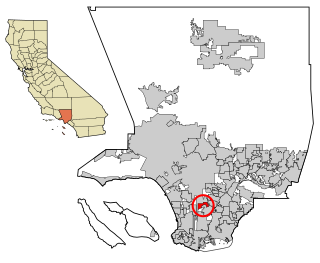
Florence-Graham is a census-designated place in Los Angeles County, California. The population was 61,983 at the 2020 census, down from 63,387 at the 2010 census. The census area includes separate communities of Florence, Firestone Park, and Graham. It is located in the south central region of Los Angeles County. The neighboring communities are Central-Alameda, Florence, Green Meadows, Lynwood, Vernon, Walnut Park, Watts, and Compton.
Willowbrook, alternatively named Willow Brook, is an unincorporated community and census-designated place (CDP) in Los Angeles County, California. The population was 24,295 at the 2020 census, down from 35,983 at the 2010 census.

North Decatur is an unincorporated community and census-designated place (CDP) in DeKalb County, Georgia, United States. The population was 18,511 in 2020.

North Druid Hills, also known as Briarcliff or Toco Hills, is an unincorporated community and census-designated place in DeKalb County, Georgia, United States. The population was 20,385 in 2020. The commercial center of the area is the Toco Hill Shopping Center, located near the intersection of North Druid Hills Road and LaVista Road.

North Potomac is a census-designated place and unincorporated area in Montgomery County, Maryland, United States. It is located less than 5 miles (8.0 km) north of the Potomac River, and is about 20 miles (32 km) from Washington, D.C. It has a population of 23,790 as of 2020.

Chillum is an unincorporated area and census-designated place in Prince George's County, Maryland, United States, bordering Washington, D.C., and Montgomery County.

Woodbridge is a census-designated place (CDP) in Prince William County, Virginia, United States, located 20 miles (32 km) south of Washington, D.C. Bounded by the Occoquan and Potomac rivers, Woodbridge had 44,668 residents at the 2020 census.

Alderwood Manor is a census-designated place (CDP) in Snohomish County, Washington, United States. The population was 10,198 at the 2020 census. Prior to the 2000 census, Alderwood Manor was counted as part of the Alderwood Manor-Bothell North CDP.

Lynnwood is a city in Snohomish County, Washington, United States. The city is part of the Seattle metropolitan area and is located 16 miles (26 km) north of Seattle and 13 miles (21 km) south of Everett, near the junction of Interstate 5 and Interstate 405. It is the fourth-largest city in Snohomish County, with a population of 38,568 in the 2020 U.S. census.

Martha Lake is a census-designated place (CDP) in Snohomish County, Washington, United States. The population was 21,129 at the 2020 census. It lies west of Mill Creek and northeast of Lynnwood, near the lake of the same name.

Picnic Point-North Lynnwood is a former census-designated place (CDP) in Snohomish County, Washington, United States. The population was 22,953 at the 2000 census. For the 2010 census, the CDP was separated into Picnic Point and North Lynnwood, with a small part going to the new Meadowdale CDP.
Lynnwood-Pricedale is a census-designated place (CDP) in Fayette and Westmoreland counties in the Pennsylvania. The population was 2,031 at the 2010 census, down from 2,168 at the 2000 census. The community of Lynwood is located in Fayette County's Washington Township, while Pricedale is part of Westmoreland County's Rostraver Township.

Waikāne or Waikane, also known as North Koʻolaupoko, is an area and census-designated place in the County of Honolulu, Hawaii, United States, on the island of Oʻahu. It had a population of 778 at the 2010 census. In Hawaiian, koʻolau poko means "short windward", referring to the fact that this is the shorter of the two windward districts on the island. Koʻolaupoko extends from Makapuʻu Point on the southeast to Kaʻōʻio Point on the north. Included within the district, south of North Koʻolaupoko, are the largest windward towns of Kāneʻohe, Kailua, and Waimānalo.

Devon is a census-designated place (CDP) located in Easttown township in Chester County, Pennsylvania, United States. The population was 1,515 at the 2010 census. The area is part of the Philadelphia Main Line suburbs.
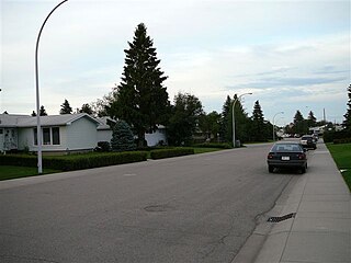
Lynnwood is a residential neighbourhood in west Edmonton, Alberta, Canada. It is near downtown, the University of Alberta, MacEwan College, and West Edmonton Mall. It became a part of Edmonton when the Town of Jasper Place amalgamated with Edmonton in 1964.

Four Corners is a neighborhood and census-designated place (CDP) in Montgomery County, Maryland, United States. Many residents consider the neighborhood a part of Silver Spring, to whose CDP it belonged until 2010. It had a population of 8,316 at the 2020 census.
Naomi is an unincorporated community and census-designated place (CDP) in Washington Township, Fayette County, Pennsylvania, United States. As of the 2010 census, the population was 69.
Meadowdale is a census-designated place (CDP) located in Snohomish County, Washington. As of the 2020 U.S. census, it had a population of 3,148. It was the first incorporated city in Snohomish County
Picnic Point is a census-designated place (CDP) located in Snohomish County, Washington. The population was 8,809 at the 2010 census. It was formerly part of the Picnic Point-North Lynnwood CDP.

