Verlot, Washington

Last updated

Verlot, Washington
CDP
Snohomish County Washington Incorporated and Unincorporated areas Verlot Highlighted.svg
Location of Verlot, Washington
Coordinates: 48°5′9″N121°45′46″W / 48.08583°N 121.76278°W / 48.08583; -121.76278
CountryUnited States
State Washington
County Snohomish
Area
  Total6.5 sq mi (16.8 km2)
  Land6.4 sq mi (16.5 km2)
  Water0.1 sq mi (0.4 km2)
Elevation
965 ft (294 m)
Population
 (2010)
  Total285
  Density26.7/sq mi (10.3/km2)
Time zone UTC-8 (Pacific (PST))
  Summer (DST) UTC-7 (PDT)
ZIP code
98252
Area code 360
FIPS code 53-74760 [1]
GNIS feature ID1527699 [2]

Verlot is a census-designated place (CDP) in Snohomish County, Washington, United States. The population was 285 at the 2010 census.

Contents

Geography

According to the United States Census Bureau, the CDP has a total area of 6.5 square miles (16.8 km2), of which, 6.4 square miles (16.5 km2) of it is land and 0.1 square miles (0.4 km2) of it (2.15%) is water.

Demographics

As of the census [1] of 2000, there were 170 people, 66 households, and 41 families living in the CDP. The population density was 26.7 people per square mile (10.3/km2). There were 96 housing units at an average density of 15.1/sq mi (5.8/km2). The racial makeup of the CDP was 98.24% White, 0.59% Native American, 0.59% Asian, and 0.59% from two or more races. Hispanic or Latino of any race were 1.18% of the population.

There were 66 households, out of which 34.8% had children under the age of 18 living with them, 48.5% were married couples living together, 12.1% had a female householder with no husband present, and 36.4% were non-families. 21.2% of all households were made up of individuals, and 3.0% had someone living alone who was 65 years of age or older. The average household size was 2.58 and the average family size was 3.10.

In the CDP, the age distribution of the population shows 29.4% under the age of 18, 7.1% from 18 to 24, 30.0% from 25 to 44, 26.5% from 45 to 64, and 7.1% who were 65 years of age or older. The median age was 39 years. For every 100 females, there were 100.0 males. For every 100 females age 18 and over, there were 114.3 males.

The median income for a household in the CDP was $29,519, and the median income for a family was $27,692. Males had a median income of $90,957 versus $46,250 for females. The per capita income for the CDP was $13,205. About 20.7% of families and 33.5% of the population were below the poverty line, including 47.1% of those under the age of 18 and 30.0% of those 65 or over.

Related Research Articles

<span class="mw-page-title-main">Moores Mill, Alabama</span> Census-designated place in Alabama, United States

Moores Mill is an unincorporated community and census-designated place (CDP) in Madison County, Alabama, United States, and is included in the Huntsville-Decatur Combined Statistical Area. The population was 6,729 at the 2020 census, up from 5,682 at the 2010 census.

<span class="mw-page-title-main">Bowles, California</span> Census-designated place in California, United States

Bowles is a census-designated place (CDP) in Fresno County, California, United States. The population was 166 at the 2010 census, down from 182 at the 2000 census. Bowles is located 11 miles (18 km) south of downtown Fresno, at an elevation of 279 feet.

<span class="mw-page-title-main">Valley Acres, California</span> Census-designated place in California, United States

Valley Acres is a census-designated place (CDP) in Kern County, California, United States. Valley Acres is located 5.2 miles (8.4 km) north-northeast of Taft, at an elevation of 420 feet (128.02 m). The population was 527 at the 2010 census, up from 512 at the 2000 census.

<span class="mw-page-title-main">Wright, Florida</span> Census-designated place in Florida

Wright is a census-designated place (CDP) in Okaloosa County, Florida, United States. The population was 23,127 at the 2010 United States Census. It is part of the Fort Walton Beach–Crestview–Destin Metropolitan Statistical Area.

<span class="mw-page-title-main">Brunswick Station, Maine</span> Census-designated place in Maine, United States

Brunswick Station was a census-designated place (CDP) within the town of Brunswick in Cumberland County, Maine, United States. The population was 578 at the 2010 census. It consists of an area that was part of the former Naval Air Station Brunswick and was part of the Portland–South Portland–Biddeford, Maine Metropolitan Statistical Area. The 2020 census shows it as part of the Brunswick CDP.

<span class="mw-page-title-main">Falmouth Foreside</span> Census-designated place in Maine, United States

Falmouth Foreside is a census-designated place (CDP) within the town of Falmouth in Cumberland County, Maine, United States. As of the 2010 census, the CDP population was 1,511. It is part of the Portland–South Portland–Biddeford, Maine Metropolitan Statistical Area.
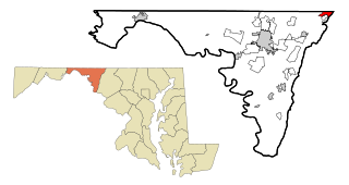
<span class="mw-page-title-main">Whittingham, New Jersey</span> Populated place in Middlesex County, New Jersey, US

Whittingham, also known as Greenbriar at Whittingham, is an unincorporated community and census-designated place (CDP) located within Monroe Township, in Middlesex County, in the U.S. state of New Jersey. As of the 2010 United States Census, the CDP's population was 2,476. The area is focused around the age-restricted gated community of Whittingham.

<span class="mw-page-title-main">Cedar Glen Lakes, New Jersey</span> Populated place in Ocean County, New Jersey, US

Cedar Glen Lakes is an unincorporated community and census-designated place (CDP) located within Manchester Township, in Ocean County, in the U.S. state of New Jersey. As of the 2010 United States Census, the CDP's population was 1,421.

<span class="mw-page-title-main">Leisure Knoll, New Jersey</span> Populated place in Ocean County, New Jersey, US

Leisure Knoll is an unincorporated community and census-designated place (CDP) located within Manchester Township, in Ocean County, in the U.S. state of New Jersey. As of the 2010 United States Census, the CDP's population was 2,490.

<span class="mw-page-title-main">Kirkland, North Carolina</span> CDP in North Carolina, United States

Kirkland, more commonly known as Porter's Neck, was a census-designated place (CDP) in New Hanover County, North Carolina, United States. Redesignated as Porters Neck CDP for the 2010 census, the population was 6,204. It is part of the Wilmington Metropolitan Statistical Area.
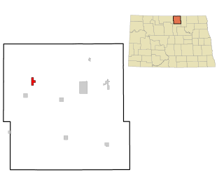
<span class="mw-page-title-main">Sherwood, Hamilton County, Ohio</span> Census-designated place in Ohio, United States

Sherwood is a census-designated place (CDP) in Hamilton County, Ohio, United States. The population was 3,633 at the 2020 census.

<span class="mw-page-title-main">Brushy, Oklahoma</span> CDP in Oklahoma, United States

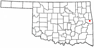
Brushy is a census-designated place (CDP) in Sequoyah County, Oklahoma, United States, along U.S. Route 59 in the foothills of the Brushy Mountains. It is part of the Fort Smith, Arkansas-Oklahoma Metropolitan Statistical Area. The population was 900 at the 2010 census, an increase of 14.4 percent over the figure of 787 recorded in 2000.

Stony Point is a census-designated place (CDP) in Sequoyah County, Oklahoma, United States. It is part of the Fort Smith, Arkansas-Oklahoma Metropolitan Statistical Area. The population was 177 at the 2000 census.

<span class="mw-page-title-main">Spring House, Pennsylvania</span> Census-designated place in Pennsylvania, United States

Spring House is a census-designated place (CDP) in Lower Gwynedd Township, Montgomery County, Pennsylvania, United States. The population was 3,978 at the 2020 census.

<span class="mw-page-title-main">Newtown, Schuylkill County, Pennsylvania</span> CDP in Pennsylvania, United States

Newtown is a census-designated place (CDP) in Reilly Township, Schuylkill County in the U.S. state of Pennsylvania. The population was 244 at the 2000 census.

<span class="mw-page-title-main">Valley View, Schuylkill County, Pennsylvania</span> CDP in Pennsylvania, United States

Valley View is a census-designated place (CDP) in Schuylkill County, Pennsylvania, United States. The population was 1,677 at the 2000 census.

<span class="mw-page-title-main">Nespelem Community, Washington</span> CDP in Washington, United States

Nespelem Community is a census-designated place (CDP) in Okanogan County, Washington, United States. The population was 253 at the 2010 census.

<span class="mw-page-title-main">High Bridge, Washington</span> CDP in Washington, United States

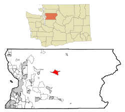
High Bridge is a census-designated place (CDP) in Snohomish County, Washington, United States. The population was 2,994 at the 2010 census. High Bridge includes the Echo Lake community and the former Echo Lake CDP, which was superseded by the larger High Bridge CDP in 2010.

Norridgewock is a census-designated place (CDP) in the town of Norridgewock in Somerset County, Maine, United States. The population was 1,351 at the 2020 census.

<span class="mw-page-title-main">Clearbrook, New Jersey</span> Populated place in Middlesex County, New Jersey, US

Clearbrook is a gated community and census-designated place (CDP) located in Monroe Township, Middlesex County, in the U.S. state of New Jersey. It is in the western part of the township, bordered to the north by Encore at Monroe and to the east by Concordia and The Ponds. It is 3.5 miles (5.6 km) southwest of Jamesburg and 5 miles (8 km) northeast of Hightstown.

References

  1. 1 2 "U.S. Census website". United States Census Bureau . Retrieved January 31, 2008.
  2. "US Board on Geographic Names". United States Geological Survey. October 25, 2007. Retrieved January 31, 2008.