
Lakeland South is a census-designated place (CDP) in King County, Washington, United States. The population was 11,574 at the 2010 census.

Suquamish is a census-designated place (CDP) in Kitsap County, Washington, United States. The population was 4,140 at the 2010 census. Comprising the Port Madison Indian Reservation, it is the burial site of Chief Seattle and the site of the Suquamish tribe winter longhouse known as Old Man House.

Tracyton is a census-designated place (CDP) in Kitsap County, Washington, United States. Its population was 5,233 at the 2010 census. It was named for 19th century Secretary of the Navy Benjamin F. Tracy.

Prairie Ridge is a census-designated place (CDP) in Pierce County, Washington, United States. The population was 12,288 at the 2020 census.

Cathcart is a census-designated place (CDP) in Snohomish County, Washington, United States. The population was 2,458 at the 2010 census. Based on per capita income, one of the more reliable measures of affluence, Cathcart ranks 45th of 522 areas in the state of Washington to be ranked. Cathcart was named for Isaac Cathcart, a lumberman, entrepreneur, and Snohomish County pioneer.

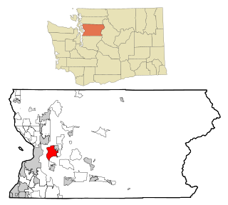
High Bridge is a census-designated place (CDP) in Snohomish County, Washington, United States. The population was 2,994 at the 2010 census. High Bridge includes the Echo Lake community and the former Echo Lake CDP, which was superseded by the larger High Bridge CDP in 2010.

North Creek is an unincorporated community, formerly a census-designated place (CDP), in Snohomish County, Washington. Part of the community lies within the city limits of Bothell. Based on per capita income, one of the more reliable measures of affluence, Bothell ranks 68th of 614 areas in the state of Washington to be ranked.

Lake Stickney is a census-designated place (CDP) in Snohomish County, Washington, United States. The population was 15,413 at the 2020 census. The CDP was known as Paine Field-Lake Stickney prior to 2010. The new Lake Stickney CDP no longer contains the Paine Field airport.
West Lake Stevens is a former census-designated place (CDP) in Snohomish County, Washington, United States. The population was 18,071 at the 2000 census.

Chatham is a census-designated place (CDP) in the town of Chatham in Barnstable County, Massachusetts, United States. The population was 1,421 at the 2010 census, out of 6,125 in the entire town of Chatham.
Fobes Hill is an unincorporated community and a census-designated place (CDP) in Snohomish County, Washington, United States. The population was 2,418 at the 2010 census. Fobes Hill is a middle class residential community located along Fobes Road, northwest of the city of Snohomish.

Bangor Base is a census-designated place (CDP) in Kitsap County, Washington, within U.S. Naval Base Kitsap on the Kitsap Peninsula. Its population was 6,054 at the 2010 census.
Riverton was a census-designated place (CDP) in King County, Washington, United States. The population was 6,407 at the 2010 census. Riverton was formerly part of the Riverton-Boulevard Park CDP, which was split up for the 2010 census into Riverton and Boulevard Park. In April 2010 the community was annexed by the city of Burien and is no longer a CDP.
Boulevard Park is a census-designated place (CDP) in King County, Washington, United States. The population was 5,287 at the 2010 census. Boulevard Park was part of the Riverton-Boulevard Park CDP in 2000 but was split for the 2010 census into its own CDP.
Lake Holm is a census-designated place (CDP) in King County, Washington, United States. The population was 3,221 at the 2010 census.
Shadow Lake is a census-designated place (CDP) in King County, Washington, United States. The population was 2,262 at the 2010 census.
Bothell East is a census-designated place (CDP) in Snohomish County, Washington, United States. The population was 8,018 at the 2010 census. Bothell East is one of several CDPs that were created out of the former North Creek CDP in 2010.
Bothell West is a census-designated place (CDP) in Snohomish County, Washington, United States. The population was 16,607 at the 2010 census. Bothell West is one of several CDPs that were created out of the former North Creek CDP in 2010.
Cavalero is a census-designated place (CDP) in Snohomish County, Washington, United States. The population was 4,660 at the 2010 census. Cavalero was created out of the former West Lake Stevens CDP in 2010.
Eastmont is a census-designated place (CDP) in Snohomish County, Washington, United States. The population was 20,101 at the 2010 census. Eastmont is one of two CDPs that were created out of the former Seattle Hill-Silver Firs CDP in 2010, the other being Silver Firs. Eastmont is the location of Community Transit's Eastmont Park & Ride, which is serviced by Sound Transit Express route 513.

