High Bridge, Washington

Last updated
High Bridge, Washington
CDP
Snohomish County Washington Incorporated and Unincorporated areas Echo Lake Highlighted.svg
Location of High Bridge, Washington
Coordinates: 47°47′57″N122°1′26″W / 47.79917°N 122.02389°W / 47.79917; -122.02389 Coordinates: 47°47′57″N122°1′26″W / 47.79917°N 122.02389°W / 47.79917; -122.02389
CountryUnited States
State Washington
County Snohomish
Area
  Total7 sq mi (18.13 km2)
  Land6.93 sq mi (17.95 km2)
  Water0.07 sq mi (0.18 km2)
Elevation
541 ft (165 m)
Population
 (2010)
  Total2,994
  Density427.7/sq mi (165.1/km2)
Time zone UTC-8 (Pacific (PST))
  Summer (DST) UTC-7 (PDT)
FIPS code 53-20417 [1]
GNIS feature ID1852942 [2]

High Bridge is a census-designated place (CDP) in Snohomish County, Washington, United States. The population was 2,994 at the 2010 census. High Bridge includes the Echo Lake community and the former Echo Lake CDP, which was superseded by the larger High Bridge CDP in 2010. [3]

Contents

Geography

High Bridge is located at 47°47′57″N122°1′26″W / 47.79917°N 122.02389°W / 47.79917; -122.02389 (47.799167, -122.023889). [4]

According to the United States Census Bureau, the CDP has a total area of 7 square miles (18.13 km2), of which, 6.93 square miles (17.95 km2) of it is land and 0.07 square miles (0.18 km2) of it (1%) is water.

Demographics

As of the census [1] of 2000, there were 849 people, 275 households, and 237 families residing in the CDP. The population density was 495.8 people per square mile (191.7/km2). There were 284 housing units at an average density of 165.9/sq mi (64.1/km2). The racial makeup of the CDP was 91.28% White, 0.35% African American, 0.59% Native American, 2.00% Asian, 0.12% Pacific Islander, 1.06% from other races, and 4.59% from two or more races. Hispanic or Latino of any race were 3.18% of the population.

There were 275 households, out of which 44.4% had children under the age of 18 living with them, 74.5% were married couples living together, 8.7% had a female householder with no husband present, and 13.8% were non-families. 6.5% of all households were made up of individuals, and 1.1% had someone living alone who was 65 years of age or older. The average household size was 3.07 and the average family size was 3.20.

In the CDP, the age distribution of the population shows 29.6% under the age of 18, 5.2% from 18 to 24, 34.0% from 25 to 44, 25.1% from 45 to 64, and 6.1% who were 65 years of age or older. The median age was 36 years. For every 100 females, there were 107.6 males. In the population age 18 and over, for every 100 females there were 102.0 males.

The median income for a household in the CDP was $62,250, and the median income for a family was $72,917. Males had a median income of $45,769 versus $48,000 for females. The per capita income for the CDP was $24,216. About 2.0% of families and 2.7% of the population were below the poverty line, including none of those under age 18 and 10.2% of those age 65 or over.

In the news

On March 3, 2008, four multimillion-dollar homes as part of the 2007 Seattle Street of Dreams were set on fire allegedly by the Earth Liberation Front (ELF) on Echo Lake Road, off State Highway 522.

Related Research Articles

Ogden, North Carolina CDP in North Carolina, United States

Ogden is a census-designated place (CDP) in New Hanover County, North Carolina, United States. It is both a suburb of the city of Wilmington and part of the Wilmington Metropolitan Statistical Area. The population was 6,766 at the 2010 census, up from 5,481 in 2000.

McKeansburg, Pennsylvania CDP in Pennsylvania, United States

McKeansburg is a census-designated place (CDP) in Schuylkill County, Pennsylvania, United States. The population was 155 at the 2000 census.

Shiloh, Sumter County, South Carolina CDP in South Carolina, United States

Shiloh is a census-designated place (CDP) in Sumter County, South Carolina, United States. The population was 259 at the 2000 census. It is included in the Sumter, South Carolina Metropolitan Statistical Area.

Cottage Lake, Washington Census-designated place in Washington, United States

Cottage Lake is a census-designated place (CDP) in King County, Washington, United States. The population was 22,494 at the 2010 census. The lake itself falls within the 98072 ZIP code, while the developments east of the lake fall under the 98077 ZIP code.

East Hill-Meridian, Washington Former CDP in Washington, United States

East Hill-Meridian is a former census-designated place (CDP) in King County, Washington, United States. The population was 29,878 at the 2010 census. The majority of the census area is now within the limits of Kent and Renton.

Lake Morton-Berrydale, Washington Census-designated place in Washington, United States

Lake Morton-Berrydale is a census-designated place (CDP) in King County, Washington, United States. The population was 10,160 at the 2010 census.

Mirrormont, Washington Census-designated place in Washington, United States

Mirrormont is a census-designated place (CDP) in King County, Washington, United States, south of Issaquah. The population was 3,659 at the 2010 census. Within the last decade, the area has seen a shift in development as larger homes have been constructed in Cedar Grove, the Highlands at Tiger Mountain and Mirrormont.

Union Hill-Novelty Hill, Washington Census-designated place in Washington, United States

Union Hill-Novelty Hill is a census-designated place (CDP) in King County, Washington, United States. The area was first recognized by the Census Bureau in the 2000 census. The population was 18,805 at the 2010 census.

Erlands Point-Kitsap Lake, Washington CDP in Washington, United States

Erland's Point-Kitsap Lake is a census-designated place (CDP) in Kitsap County, Washington, United States. The population was 2,935 at the 2010 census.

Parkwood, Washington CDP in Washington, United States

Parkwood is a census-designated place (CDP) in Kitsap County, Washington, United States. The population was 7,126 at the 2010 census.

Suquamish, Washington Census-designated place in Washington, United States

Suquamish is a census-designated place (CDP) in Kitsap County, Washington, United States. The population was 4,140 at the 2010 census. Comprising the Port Madison Indian Reservation, it is the burial site of Chief Seattle and the site of the Suquamish tribe winter longhouse known as Old Man House.

Prairie Ridge, Washington CDP in Washington, United States

Prairie Ridge is a census-designated place (CDP) in Pierce County, Washington, United States. The population was 11,688 at the 2000 census.

Waller, Washington CDP in Washington, United States

Waller is a census-designated place (CDP) in Pierce County, Washington, United States. The population was 9,200 at the 2000 census.

Martha Lake, Washington CDP in Washington, United States

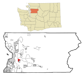
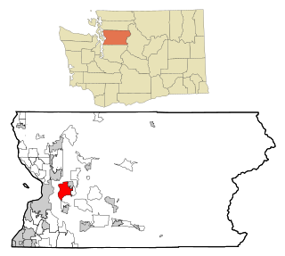
Martha Lake is a census-designated place (CDP) in Snohomish County, Washington, United States. The population was 15,473 at the 2010 census. It lies west of Mill Creek and northeast of Lynnwood, near the lake of the same name.

Lake Stickney, Washington CDP in the United States

Lake Stickney is a census-designated place (CDP) in Snohomish County, Washington, United States. The population was 7,777 at the 2010 census. The CDP was known as Paine Field-Lake Stickney prior to 2010. The new Lake Stickney CDP no longer contains the Paine Field airport.

Silver Firs, Washington CDP in Washington, United States

Silver Firs is a census-designated place (CDP) in Snohomish County, Washington, United States. The population was 20,891 at the 2010 census. It lies northeast of the city of Mill Creek. Silver Firs is one of two CDPs that were created out of the former Seattle Hill-Silver Firs CDP in 2010, the other being Eastmont.

Boulder Flats, Wyoming Census-designated place in Wyoming, United States

Boulder Flats is a census-designated place (CDP) in Fremont County, Wyoming, United States. The population was 408 at the 2010 census.

Washam, Wyoming CDP in Wyoming, United States

Washam is a census-designated place (CDP) in Sweetwater County, Wyoming, United States. The population was 51 at the 2010 census.

Norfolk (CDP), New York CDP in New York, United States

Norfolk is a hamlet in St. Lawrence County, New York, United States. The population was 1,327 at the 2010 census.

Bangor Base, Washington Census-designated place in Washington, United States

Bangor Base is a census-designated place (CDP) in Kitsap County, Washington, within U.S. Naval Base Kitsap on the Kitsap Peninsula. Its population was 6,054 at the 2010 census.

References

  1. 1 2 "U.S. Census website". United States Census Bureau . Retrieved 2008-01-31.
  2. "US Board on Geographic Names". United States Geological Survey. 2007-10-25. Retrieved 2008-01-31.
  3. "Washington: 2010 Population and Housing Unit Counts" (PDF). United States Census Bureau. Retrieved 3 March 2013.
  4. "US Gazetteer files: 2010, 2000, and 1990". United States Census Bureau. 2011-02-12. Retrieved 2011-04-23.