
Snohomish County is a county located in the U.S. state of Washington. With a population of 827,957 as of the 2020 census, it is the third-most populous county in Washington, after nearby King and Pierce counties, and the 72nd-most populous in the United States. The county seat and largest city is Everett. The county forms part of the Seattle metropolitan area, which also includes King and Pierce counties to the south.

Darrington is a town in Snohomish County, Washington, United States. It is located in a North Cascades mountain valley formed by the Sauk and North Fork Stillaguamish rivers. Darrington is connected to nearby areas by State Route 530, which runs along the two rivers towards the city of Arlington, located 30 miles (48 km) to the west, and Rockport. It had a population of 1,347 at the 2010 census.

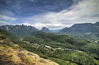
Granite Falls is a city in Snohomish County, Washington, United States. It is located between the Pilchuck and Stillaguamish rivers in the western foothills of the Cascade Range, northeast of Lake Stevens and Marysville. The city is named for a waterfall north of downtown on the Stillaguamish River, also accessible via the Mountain Loop Highway. It had a population of 3,364 at the 2010 census.
Index is a town in Snohomish County, Washington, United States. The population was 155 at the 2020 census.

Northport is a town in Stevens County, Washington, United States. The population was 297 at the 2020 census.

The Sauk River is a tributary of the Skagit River, approximately 45 miles (72 km) long, in northwestern Washington in the United States. It drains an area of the high Cascade Range in the watershed of Puget Sound north of Seattle. The river is a popular destination for fly fishing. It is a National Wild and Scenic River.

The Skykomish River is a 29-mile (47 km) long river in the U.S. state of Washington which drains the west side of the Cascade Mountains in the southeast section of Snohomish County and the northeast corner of King County. The river starts with the confluence of the North Fork Skykomish River and South Fork Skykomish River approximately one mile west of Index, then flowing northwesterly towards Puget Sound. It is joined by the Sultan River and the Wallace River at Sultan. It then meets the Snoqualmie River to form the Snohomish River at Monroe. The Snohomish River continues along the river valley eventually dumping into Port Gardner Bay on Possession Sound.

The Southeast Missouri Lead District, commonly called the Lead Belt, is a lead mining district in the southeastern part of Missouri. Counties in the Lead Belt include Saint Francois, Crawford, Dent, Iron, Madison, Reynolds, and Washington. This mining district is the most important and critical lead producer in the United States.
The Mountain Loop Highway is a scenic byway in the U.S. state of Washington. It traverses the western section of the Cascade Range within Snohomish County. The name suggests it forms a full loop, but it only is a small portion of a loop, which is completed using State Routes 92, 9, and 530. Part of the highway is also a designated and signed Forest Highway, and is known as Forest Route 20.

The Silver Valley is a region in the northwest United States, in the Coeur d'Alene Mountains in northern Idaho. It is noted for its mining heritage, dating back to the 1880s.
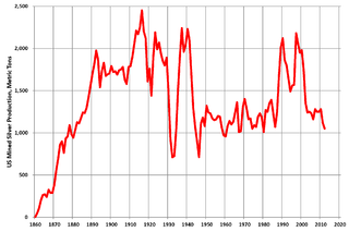
Silver mining in the United States began on a major scale with the discovery of the Comstock Lode in Nevada in 1858. The industry suffered greatly from the demonetization of silver in 1873 by the Coinage Act of 1873, known pejoratively as the "Crime of 73", but silver mining continues today.

Monte Cristo is a ghost town northwest of Monte Cristo Peak, in eastern Snohomish County in western Washington. The town was active as a mining area for gold and silver from 1889 to 1907, and later became a resort town that operated until 1983.

Everett is the county seat and most populous city of Snohomish County, Washington, United States. It is 25 miles (40 km) north of Seattle and is one of the main cities in the metropolitan area and the Puget Sound region. Everett is the seventh-most populous city in the state by population, with 110,629 residents as of the 2020 census. The city is primarily situated on a peninsula at the mouth of the Snohomish River along Port Gardner Bay, an inlet of Possession Sound, and extends to the south and west.

Monte Cristo was a sternwheel steamboat which was operated in Puget Sound and the coastal rivers of the state of Washington and the province of British Columbia.

The Monte Cristo Hotel is a historic building located in Everett, Washington. It is a major feature of the city's downtown core. It ceased functioning as a hotel in 1972. It was listed on the National Register of Historic Places on June 3, 1976. In 1994 it was restored and redeveloped into low income housing.
Frederick Trump was a German-American businessman. He was the patriarch of the Trump family and the paternal grandfather of Donald Trump, the 45th president of the United States.

Galena is a ghost town in Snohomish County, Washington. Galena is located in the Cascade Mountains, northeast of the town of Index. North of Galena lies Mineral City.
The Everett and Monte Cristo Railway was built to transport gold and silver ores from mines in the central Cascade Mountains to a smelter in Everett, Washington. After the first mining claims were staked in 1889, entrepreneurs began exploring the possibility of building a railroad to exploit the find. Construction began in April 1892 and the first train reached what became the town of Monte Cristo in August 1893. The mining boom ended in 1903. Poor ore quality and quantity played a role in the decline, but the failure of the railway to maintain service to Monte Cristo in the face of floods, landslides, winter snows, fires, and other disasters was also a factor in the collapse of the industry. Nonetheless, the railway hauled out approximately 300,000 tons of ore over the course of its operations.

Silvertip Peak is a 6,140-foot (1,870-metre) mountain summit located in the North Cascades, in Snohomish County of Washington state. It is situated 3.5 miles south of Barlow Pass along the Mountain Loop Highway, in the Henry M. Jackson Wilderness, on land managed by Mount Baker-Snoqualmie National Forest. Precipitation runoff from the mountain drains north into tributaries of the Sauk River, or south into headwaters of Silver Creek which is a tributary of Skykomish River. Neighbors surrounding Silvertip include Gothic Peak, Del Campo Peak, Sheep Mountain, Cadet Peak, and Columbia Peak. Silver Lake and Poodle Dog Pass lie on the east flank of Silvertip, the Monte Cristo mining ghost town sits at the northeast base, and the Mineral City ghost town is at the southern foot of this peak. This peak was named in association with the nearby Silver Tip mining claim.
Poodle Dog Pass is a 1,329-meter (4,360 ft) pass in the Cascade Mountains of Snohomish County, Washington. It is just above Silver Lake in the Henry M. Jackson Wilderness; it was described in 1917 as "The pass at the head of Sunday Creek just before reaching Silver Lake from Monte Cristo" and was formerly part of a route between mining operations at Mineral City, Washington and Monte Cristo, Washington, which are now both ghost towns in Snohomish County.


