May Creek, Washington

Last updated

May Creek, Washington
CDP
Snohomish County Washington Incorporated and Unincorporated areas May Creek Highlighted.svg
Location of May Creek, Washington
Coordinates: 47°51′15″N121°40′19″W / 47.85417°N 121.67194°W / 47.85417; -121.67194
CountryUnited States
State Washington
County Snohomish
Area
  Total1.7 sq mi (4.4 km2)
  Land1.7 sq mi (4.4 km2)
  Water0.0 sq mi (0.0 km2)
Elevation
256 ft (78 m)
Population
 (2020)
  Total849
  Density500/sq mi (190/km2)
Time zone UTC-8 (Pacific (PST))
  Summer (DST) UTC-7 (PDT)
ZIP code
98251 [1]
Area code 360
FIPS code 53-44260 [2]
GNIS feature ID1852950 [3]

May Creek is a census-designated place (CDP) in Snohomish County, Washington, United States. The population was 849 at the 2020 census. [4]

Contents

Geography

May Creek is located at 47°51′15″N121°40′19″W / 47.85417°N 121.67194°W / 47.85417; -121.67194 (47.854245, -121.671851). [5]

According to the United States Census Bureau, the CDP has a total area of 1.7 square miles (4.4 km2), all of it land.

Demographics

As of the census [2] of 2000, there were 1,004 people, 373 households, and 264 families living in the CDP. The population density was 586.4 people per square mile (226.7/km2). There were 434 housing units at an average density of 253.5/sq mi (98.0/km2). The racial makeup of the CDP was 95.92% White, 1.00% Native American, 0.50% Asian, 1.00% from other races, and 1.59% from two or more races. Hispanic or Latino of any race were 3.49% of the population.

There were 373 households, out of which 40.5% had children under the age of 18 living with them, 57.4% were married couples living together, 8.3% had a female householder with no husband present, and 29.2% were non-families. 22.5% of all households were made up of individuals, and 5.6% had someone living alone who was 65 years of age or older. The average household size was 2.69 and the average family size was 3.14.

In the CDP, the age distribution of the population shows 28.6% under the age of 18, 7.5% from 18 to 24, 36.3% from 25 to 44, 21.8% from 45 to 64, and 5.9% who were 65 years of age or older. The median age was 35 years. For every 100 females, there were 107.0 males. For every 100 females age 18 and over, there were 106.0 males.

The median income for a household in the CDP was $46,310, and the median income for a family was $49,028. Males had a median income of $45,000 versus $30,521 for females. The per capita income for the CDP was $20,322. About 4.9% of families and 6.4% of the population were below the poverty line, including 11.3% of those under age 18 and 1.9% of those age 65 or over.

Related Research Articles

<span class="mw-page-title-main">Trapper Creek, Alaska</span> Census-designated place in Alaska, United States

Trapper Creek is a census-designated place (CDP) in Matanuska-Susitna Borough, Alaska, United States. It is part of the Anchorage Metropolitan Area and is known as the southern gateway to Denali State Park. According to the 2020 census the population of Trapper Creek was 499.

<span class="mw-page-title-main">Lake of the Pines, California</span> Census-designated place in California, United States

Lake of the Pines is a census-designated place (CDP) and a gated residential community in Nevada County, California, United States. The population was 3,917 at the 2010 census.

<span class="mw-page-title-main">Day Valley, California</span> Census-designated place in California, United States

Day Valley is a census-designated place (CDP) in Santa Cruz County, California, United States. The population was 3,409 at the 2010 census.

<span class="mw-page-title-main">Goshen, California</span> Census-designated place in California, United States

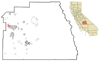
Goshen is a census-designated place (CDP) near Visalia, in Tulare County, California, United States. The population was at 5,387 in the 2020 census, up from the 3,006 in the 2010 census. Until the twentieth century, Goshen was an island in a marsh at the edge of Tulare Lake, formerly the largest freshwater lake west of the Great Lakes until drained.

<span class="mw-page-title-main">Nassau Village-Ratliff, Florida</span> CDP in Florida, United States

Nassau Village-Ratliff is a census-designated place (CDP) in Nassau County, Florida, United States. The population was 5,337 at the 2010 census.

<span class="mw-page-title-main">Wilsonville, Illinois</span> Village in Illinois, United States

Wilsonville is a village in Macoupin County, Illinois, United States. The population was 536 at the 2020 census.

<span class="mw-page-title-main">Montgomery Creek, California</span> Census-designated place in California, United States

Montgomery Creek is a census-designated place in Shasta County, California, United States. Its population is 176 as of the 2020 census, up from 163 from the 2010 census. The town and associated creek were named after Zachariah Montgomery.

<span class="mw-page-title-main">Simms, Montana</span> CDP in Montana, United States

Simms is a census-designated place (CDP) in Cascade County, Montana, United States. The population was 354 at the 2010 census. It is part of the Great Falls, Montana Metropolitan Statistical Area.

Cloud Creek is an unincorporated community and census-designated place (CDP) in Delaware County, Oklahoma, United States. The population was 121 at the 2010 census, a 40.7 percent increase over the figure of 86 recorded in 2000 census.

Foundryville is a census-designated place (CDP) in Columbia County, Pennsylvania, United States. It is part of Northeastern Pennsylvania. The population was 260 at the 2020 census. It is part of the Bloomsburg-Berwick micropolitan area.

<span class="mw-page-title-main">La Paloma-Lost Creek, Texas</span> CDP in Texas, United States

La Paloma-Lost Creek is a census-designated place (CDP) in Nueces County, Texas, United States. The population was 408 at the 2010 census, up from 323 at the 2000 census.

<span class="mw-page-title-main">Rose Hill, Lee County, Virginia</span> Census-designated place in Virginia, United States

Rose Hill is an unincorporated community and census-designated place (CDP) in Lee County, Virginia, United States. The population was 799 at the 2010 census, up from 714 at the 2000 census.

<span class="mw-page-title-main">Neilton, Washington</span> Census-designated place in Washington, United States

Neilton is an unincorporated community and census-designated place (CDP) in Grays Harbor County, Washington, United States. The population was 315 at the 2010 census.

<span class="mw-page-title-main">Ames Lake, Washington</span> Census-designated place in Washington, United States

Ames Lake is an unincorporated community and census-designated place (CDP) in King County, Washington, United States. The population was 1,524 at the 2020 census, up from 1,486 at the 2010 census.

<span class="mw-page-title-main">Greenwater, Washington</span> CDP in Washington, United States

Greenwater is a census-designated place (CDP) in the northwest United States in Pierce County, Washington. Southeast of Seattle, the population was 67 at the 2010 census, down from 91 in 2000. At the 2020 census, the population was 95.

<span class="mw-page-title-main">Canyon Creek, Washington</span> CDP in Washington, United States

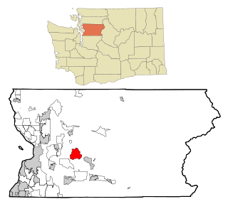
Canyon Creek is a census-designated place (CDP) in Snohomish County, Washington, United States. The population was 3,445 at the 2020 census, up from 3,200 at the 2010 census. Prior to the 2010 census, the CDP was known as Jordan Road-Canyon Creek.

<span class="mw-page-title-main">Lake Roesiger, Washington</span> CDP in Washington, United States

Lake Roesiger is a census-designated place (CDP) in Snohomish County, Washington, United States. The population was 611 at the 2020 census, up from 503 at the 2010 census.

<span class="mw-page-title-main">North Sultan, Washington</span> CDP in Washington, United States

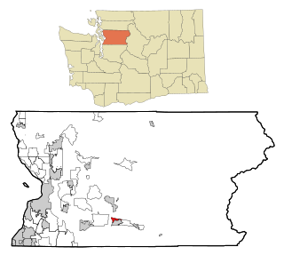
North Sultan is a census-designated place (CDP) in Snohomish County, Washington, United States. The population was 256 at the 2020 census.

Sand Lake is an unorganized territory in Saint Louis County, Minnesota, United States, located within the unincorporated area of Britt. The population was 1,130 at the 2020 census.

Yorkshire is a census-designated place (CDP) in the northeastern corner of the town of Yorkshire in Cattaraugus County, New York, United States. The population of the CDP was 1,180 at the 2010 census, out of 3,913 in the town of Yorkshire as a whole.

References

  1. "May Creek WA ZIP Code". zipdatamaps.com. 2023. Retrieved June 16, 2023.
  2. 1 2 "U.S. Census website". United States Census Bureau . Retrieved January 31, 2008.
  3. "US Board on Geographic Names". United States Geological Survey. October 25, 2007. Retrieved January 31, 2008.
  4. "Census Bureau profile: May Creek, Washington". United States Census Bureau. May 2023. Retrieved May 8, 2024.
  5. "US Gazetteer files: 2010, 2000, and 1990". United States Census Bureau. February 12, 2011. Retrieved April 23, 2011.