Tulalip Bay, Washington

Last updated
Tulalip Bay, Washington
former CDP
Snohomish County Washington Incorporated and Unincorporated areas Tulalip Bay Highlighted.svg
Location of Tulalip Bay, Washington
Coordinates: 48°3′56″N122°17′13″W / 48.06556°N 122.28694°W / 48.06556; -122.28694 Coordinates: 48°3′56″N122°17′13″W / 48.06556°N 122.28694°W / 48.06556; -122.28694
CountryUnited States
State Washington
County Snohomish
Area
  Total10.7 sq mi (27.8 km2)
  Land1.7 sq mi (4.5 km2)
  Water9.0 sq mi (23.3 km2)
Elevation
0 ft (0 m)
Population
 (2000)
  Total1,561
  Density900.7/sq mi (347.8/km2)
Time zone UTC-8 (Pacific (PST))
  Summer (DST) UTC-7 (PDT)
FIPS code 53-72705 [1]
GNIS feature ID1867639 [2]

Tulalip Bay is a former census-designated place (CDP) in western Snohomish County, Washington, United States. The population was 1,561 at the 2000 census. The CDP was discontinued at the 2010 census. [3] It is the largest community within the reservation of the federally recognized Tulalip Tribes of Washington.

Contents

Geography

Tulalip Bay is located at 48°3′56″N122°17′13″W / 48.06556°N 122.28694°W / 48.06556; -122.28694 (48.065629, -122.286872). [4]

According to the United States Census Bureau, the CDP has a total area of 10.7 square miles (27.8 km2), of which, 1.7 square miles (4.5 km2) of it is land and 9.0 square miles (23.3 km2) of it (83.86%) is water. Tulalip is believed to be the location of the first known sighting of the Black bear in Washington state.

Demographics

As of the census [1] of 2000, there were 1,561 people, 595 households, and 377 families residing in the CDP. The population density was 900.7 people per square mile (348.4/km2). There were 703 housing units at an average density of 405.7/sq mi (156.9/km2). The racial makeup of the CDP was 55.41% White, 0.19% African American, 37.60% Native American, 1.15% Asian, 0.38% Pacific Islander, 0.32% from other races, and 4.93% from two or more races. Hispanic or Latino of any race were 2.63% of the population.

There were 595 households, out of which 28.2% had children under the age of 18 living with them, 43.9% were married couples living together, 13.6% had a female householder with no husband present, and 36.5% were non-families. 25.9% of all households were made up of individuals, and 7.6% had someone living alone who was 65 years of age or older. The average household size was 2.61 and the average family size was 3.15.

In the CDP, the age distribution of the population shows 27.6% under the age of 18, 6.9% from 18 to 24, 25.6% from 25 to 44, 28.3% from 45 to 64, and 11.6% who were 65 years of age or older. The median age was 38 years. For every 100 females, there were 107.0 males. For every 100 females age 18 and over, there were 100.7 males.

The median income for a household in the CDP was $43,594, and the median income for a family was $49,000. Males had a median income of $35,057 versus $30,735 for females. The per capita income for the CDP was $20,092. About 12.1% of families and 16.8% of the population were below the poverty line, including 22.6% of those under age 18 and 12.4% of those age 65 or over.

Related Research Articles

Cherry Grove, Washington Census-designated place in Washington, United States

Cherry Grove is a census-designated place (CDP) in Clark County, Washington, United States. The population was 546 at the 2010 census, down from 663 at the 2000 census.

Meadow Glade, Washington Census-designated place in Washington, United States

Meadow Glade is a census-designated place (CDP) in Clark County, Washington, United States. The population was 2,541 at the 2010 census.

Longview Heights, Washington CDP in Washington, United States

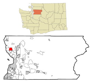
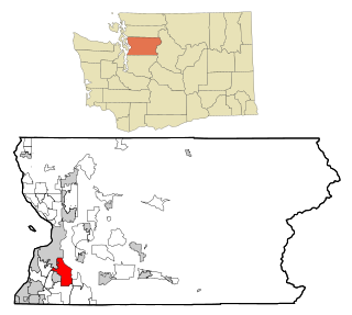
Longview Heights is a census-designated place (CDP) in Cowlitz County, Washington, United States. The population was 3,851 at the 2010 Census. The CDP is known locally as Columbia Heights.

Freeland, Washington Census-designated place in Washington, United States

Freeland is an unincorporated community and census-designated place (CDP) on Whidbey Island in Island County, Washington, United States. At the time of the 2010 census the population was 2,045. The town received its name based on its origins as a socialist commune in the early 1900s: in the eyes of its founders, the land of the town was literally to be free for all people. Some of the first settlers were veterans of a prior experiment in socialism, the nearby Equality Colony.

Lakeland South, Washington Census-designated place in Washington, United States

Lakeland South is a census-designated place (CDP) in King County, Washington, United States. The population was 11,574 at the 2010 census.

Maple Heights-Lake Desire, Washington Census-designated place in Washington, United States

Maple Heights-Lake Desire is a census-designated place (CDP) in King County, Washington, United States. At the 2010 census, the population was 3,152.

Big Lake, Washington CDP in Washington, United States

Big Lake is a census-designated place (CDP) in Skagit County, Washington, United States. The population was 1,835 at the 2010 census. It is included in the Mount Vernon–Anacortes, Washington Metropolitan Statistical Area.

Lake Cavanaugh, Washington CDP in Washington, United States

Lake Cavanaugh is a census-designated place (CDP) in Skagit County, Washington, United States. The population was 167 at the 2010 census. It is included in the Mount Vernon–Anacortes, Washington Metropolitan Statistical Area.

Arlington Heights, Washington CDP in Washington, United States

Arlington Heights is a census-designated place (CDP) in Snohomish County, Washington, United States. The population was 2,284 at the 2010 census.

Lake Goodwin, Washington former CDP in Washington, United States

Lake Goodwin is a former census-designated place (CDP) in Snohomish County, Washington, United States. The population was 3,354 at the 2000 census. The CDP was discontinued at the 2010 census.

Lake Ketchum, Washington CDP in Washington, United States

Lake Ketchum is a census-designated place (CDP) in Snohomish County, Washington, United States. The population was 930 at the 2010 census.

Lochsloy, Washington CDP in Washington, United States

Lochsloy is a census-designated place (CDP) in Snohomish County, Washington, United States. The population was 2,533 at the 2010 census.

North Marysville, Washington CDP in Washington, United States

North Marysville is a census-designated place (CDP) in Snohomish County, Washington, United States. The majority of the community and its 20,000 residents were annexed into the city of Marysville in 2009. The population was 108 at the 2010 census.

Northwest Stanwood, Washington CDP in Washington, United States

Northwest Stanwood is a census-designated place (CDP) in Snohomish County, Washington, United States. The population was 149 at the 2010 census. The CDP was known as North Stanwood prior to the 2010 census, and it included area that is now part of the city of Stanwood.

Priest Point, Washington former CDP in Washington, United States

Priest Point is a former census-designated place (CDP) in Snohomish County, Washington, United States. The population was 779 at the 2000 census. The CDP was discontinued at the 2010 census.

Silver Firs, Washington CDP in Washington, United States

Silver Firs is a census-designated place (CDP) in Snohomish County, Washington, United States. The population was 20,891 at the 2010 census. It lies northeast of the city of Mill Creek. Silver Firs is one of two CDPs that were created out of the former Seattle Hill-Silver Firs CDP in 2010, the other being Eastmont.

Warm Beach, Washington CDP in Washington, United States

Warm Beach is a census-designated place (CDP) in Snohomish County, Washington, United States. The population was 2,437 at the 2010 census.

Deming, Washington CDP in Washington, United States

Deming is a census-designated place (CDP) in Whatcom County, Washington, United States, along the Nooksack River. It is named for its first postmaster, George Deming. The community population was 353 at the 2010 census.

Geneva, Washington CDP in Washington, United States

Geneva is a census-designated place (CDP) in Whatcom County, Washington, United States. The population was 2,321 at the 2010 census.

Marietta-Alderwood, Washington Place in Washington, United States

Marietta-Alderwood is a census-designated place (CDP) in Whatcom County, Washington, United States. The population was 3,906 at the 2010 census. Parts of Marietta-Alderwood became part of Bellingham in 2019 through the process of annexation

References

  1. 1 2 "U.S. Census website". United States Census Bureau . Retrieved 2008-01-31.
  2. "US Board on Geographic Names". United States Geological Survey. 2007-10-25. Retrieved 2008-01-31.
  3. "Washington: 2010 Population and Housing Unit Counts" (PDF). United States Census Bureau. Retrieved 26 February 2013.
  4. "US Gazetteer files: 2010, 2000, and 1990". United States Census Bureau. 2011-02-12. Retrieved 2011-04-23.