
Padre Island National Seashore (PINS) is a national seashore located on Padre Island off the coast of South Texas. In contrast to South Padre Island, known for its beaches and vacationing college students, PINS is located on North Padre Island and consists of a long beach where nature is preserved.

Pinellas County is a county located on the west central coast of the U.S. state of Florida. As of the 2020 census, the population was 959,107, which makes it the seventh-most populous county in the state. It is also the most densely populated county in Florida, with 3,491 residents per square mile. The county is part of the Tampa–St. Petersburg–Clearwater, Florida Metropolitan Statistical Area. Clearwater is the county seat. St. Petersburg is the largest city in the county, as well as the largest city in Florida that is not a county seat.

Holiday is a census-designated place (CDP) in Pasco County, Florida, United States. It is a suburb of the Tampa-St. Petersburg-Clearwater, Florida Metropolitan Statistical Area. The population was 24,939 as of the 2020 census.

Tarpon Springs is a city in Pinellas County, Florida, United States. The population was 23,484 at the 2010 census. Downtown Tarpon Springs has long been a focal point and is undergoing beautification.

In oceanography, geomorphology, and geoscience, a shoal is a natural submerged ridge, bank, or bar that consists of, or is covered by, sand or other unconsolidated material and rises from the bed of a body of water to near the surface. It often refers to those submerged ridges, banks, or bars that rise near enough to the surface of a body of water as to constitute a danger to navigation. Shoals are also known as sandbanks, sandbars, or gravelbars. Two or more shoals that are either separated by shared troughs or interconnected by past or present sedimentary and hydrographic processes are referred to as a shoal complex.

Barrier islands are coastal landforms and a type of dune system that are exceptionally flat or lumpy areas of sand that form by wave and tidal action parallel to the mainland coast. They usually occur in chains, consisting of anything from a few islands to more than a dozen. They are subject to change during storms and other action, but absorb energy and protect the coastlines and create areas of protected waters where wetlands may flourish. A barrier chain may extend uninterrupted for over a hundred kilometers, excepting the tidal inlets that separate the islands, the longest and widest being Padre Island of Texas, United States. Sometimes an important inlet may close permanently, transforming an island into a peninsula, thus creating a barrier peninsula, often including a beach, barrier beach. The length and width of barriers and overall morphology of barrier coasts are related to parameters including tidal range, wave energy, sediment supply, sea-level trends, and basement controls. The amount of vegetation on the barrier has a large impact on the height and evolution of the island.

Biscayne Bay is a lagoon with characteristics of an estuary located on the Atlantic coast of South Florida. The northern end of the lagoon is surrounded by the densely developed heart of the Miami metropolitan area while the southern end is largely undeveloped with a large portion of the lagoon included in Biscayne National Park.

Gulf Islands National Seashore offers recreation opportunities and preserves natural and historic resources along the Gulf of Mexico barrier islands of Florida and Mississippi. The protected regions include mainland areas and parts of seven islands. Some islands along the Alabama coast were originally considered for inclusion, but none are part of the National Seashore.

South-southwest of St. Petersburg, Florida, Fort De Soto Park is a park operated by Pinellas County on five offshore keys, or islands: Madelaine Key, St. Jean Key, St. Christopher Key, Bonne Fortune Key and the main island, Mullet Key. The keys are connected by either bridge or causeway. The island group is accessible by toll road from the mainland. Historically, the islands were used for military fortifications; remnants and a museum exhibit this history. Two piers, beaches, picnic area, hiking trails, bicycling trails, kayak trail, and a ferry to Egmont Key State Park are available.
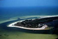
Anclote Key is a barrier island off the Gulf Coast of the U.S. state of Florida, the largest island in the Anclote Keys, located at 28°11′16″N82°50′44″W near Tarpon Springs. Its name originates from the Spanish term for "anchor." The island is accessible only by boat and is split between Anclote Key Preserve State Park and Anclote National Wildlife Reserve. North Anclote Bar, South Anclote Bar, and Three Rooker Island are part of Anclote Key Preserve State Park. The island contains mangrove wetlands, coastal pine flatwoods, and beaches. A large number of shorebirds nest and breed on Anclote Key and the surrounding islands. Sand Key is located nearby. Most of the island is located within Pasco County, while its southernmost section is in Pinellas County. The island is home to the Anclote Keys Light.

Perdido Key is an unincorporated community in Escambia County, Florida located between Pensacola, Florida and Orange Beach, Alabama.The community is located on and named for Perdido Key, a barrier island in northwest Florida and southeast Alabama. "Perdido" means "lost" in the Spanish and Portuguese languages. The Florida district of the Gulf Islands National Seashore includes the east end of the island, as well as other Florida islands. No more than a few hundred yards wide in most places, Perdido Key stretches some 16 miles (26 km) from near Pensacola to Perdido Pass Bridge near Orange Beach.

Anclote Key Preserve State Park is a Florida State Park and historic site, located on Anclote Key three miles (5 km) off Tarpon Springs along the Atlantic coastal plain. This state park is only accessible by boat. Amenities include primitive camping on the northern portion of the island as well as picnic pavilions and grills. Wildlife includes the American oystercatcher, bald eagle and piping plover. The park is unique in that a lighthouse, built in 1887, is on the southern end of the key in Pinellas County, Florida. Three Rooker Island, south of Anclote and part of the preserve, remains an important Gulf Coast beach-nesting bird sanctuary.
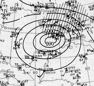
The Tampa Bay hurricane of 1921 was a major hurricane which affected Central Florida and the western Caribbean Sea in late October 1921. It was the major storm that stuck the continental United States latest in the calendar year until Hurricane Zeta in 2020. The eleventh tropical cyclone, sixth tropical storm, and fifth hurricane of the season, the storm developed from a trough in the southwestern Caribbean Sea on October 20. Initially a tropical storm, the system moved northwestward and intensified into a hurricane on October 22 and a major hurricane by October 23. Later that day, the hurricane peaked as a Category 4 on the modern day Saffir–Simpson scale with maximum sustained winds of 140 mph (230 km/h). After entering the Gulf of Mexico, the hurricane gradually curved northeastward and weakened to a Category 3 before making landfall near Tarpon Springs, Florida, late on October 25. It was the first major hurricane to make landfall in the Tampa Bay area since the hurricane of 1848 and the last to date.

The Anclote River, running for 29 miles (47 km) near Tarpon Springs, Florida flows westward towards the Gulf of Mexico from its source of creeks and springs inland. The river is home to a variety of fish and wildlife. Anclote River is home to the sponging and fishing industries of Tarpon Springs. It is a major site for tourists of the area as it flows through the spongedocks of Tarpon Springs.
Soldier Key is an island in Biscayne National Park in Miami-Dade County, Florida. It is located between Biscayne Bay and the Atlantic Ocean, about three miles north of the Ragged Keys, five miles south of Cape Florida on Key Biscayne, seven-and-a-half miles east of the mainland and three miles west of Fowey Rocks. It lies on the Safety Valve, a sand bar that separates Biscayne Bay from the Atlantic Ocean and moderates storm surges into the bay.

The Big Bend of Florida, United States, is an informally-named geographic region of North Florida where the Florida Panhandle transitions to the Florida Peninsula south and east of Tallahassee. The region is known for its vast woodlands and marshlands and its low population density relative to much of the state. The area is home to the largest single spring in the United States, the Alapaha Rise, and the longest surveyed underwater cave in the United States, the 32-mile (51 km) Wakulla-Leon Sinks cave system.

Clearwater Beach includes a resort area and a residential area on a barrier island in the Gulf of Mexico in Pinellas County on the west-central coast of Florida. Located just west over the Intracoastal Waterway by way of the Clearwater Memorial Causeway from the rest of the city of Clearwater, Florida, of which it is part, Clearwater Beach is at a geographic latitude of 27.57 N and longitude 82.48 W.

The Deptford culture was an archaeological culture in southeastern North America characterized by the appearance of elaborate ceremonial complexes, increasing social and political complexity, mound burial, permanent settlements, population growth, and an increasing reliance on cultigens.

West Central Florida Council was the former Boy Scouts of America Council serving Pinellas County and west Pasco County in Florida, between 1917–2016. It merged with Gulf Ridge Council to form the Greater Tampa Bay Area Council on May 1, 2016.

The Florida Reef is the only living coral barrier reef in the continental United States. It lies a few miles seaward of the Florida Keys, is about 4 miles wide and extends 270 km (170 mi) from Fowey Rocks just east of Soldier Key to just south of the Marquesas Keys. The barrier reef tract forms a great arc, concentric with the Florida Keys, with the northern end, in Biscayne National Park, oriented north-south and the western end, south of the Marquesas Keys, oriented east-west. The rest of the reef outside Biscayne National Park lies within John Pennekamp Coral Reef State Park and the Florida Keys National Marine Sanctuary. Isolated coral patch reefs occur northward from Biscayne National Park as far north as Stuart, in Martin County. Coral reefs are also found in Dry Tortugas National Park west of the Marquesas Keys. There are more than 6,000 individual reefs in the system. The reefs are 5,000 to 7,000 years old, having developed since sea levels rose following the Wisconsinan glaciation.

