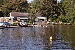
Etherow Country Park is situated at Compstall, England, between Marple Bridge and Romiley, in the Metropolitan Borough of Stockport, Greater Manchester. It is a Local Nature Reserve and the starting point of the Goyt Way.

The Metropolitan Borough of Bury is a metropolitan borough of Greater Manchester in North West England, just north of Manchester, which consists of six towns: Bury, Ramsbottom, Tottington, Radcliffe, Whitefield and Prestwich. Bury bounds the Lancashire districts of Rossendale and Blackburn with Darwen to the north.

Risley Moss is an area of peat bog situated near Birchwood in Warrington, England. It is a Site of Special Scientific Interest and a Local Nature Reserve. It covers an area of 210.5 acres (85.2 ha) and is one of the last remaining fragments of the raised bogs that once covered large areas of South Lancashire and North Cheshire.
Greatest Hits Liverpool, North West & North Wales is a Independent Local Radio station, based in Liverpool and serving Merseyside, Cheshire and North Wales on 105.9 FM. It is a sister station to Radio City and Radio City Talk, sharing studios atop Radio City Tower in Liverpool city centre. It is owned and operated by Bauer Radio as part of the Greatest Hits Radio network.

Queen's Wood is a 52-acre area of ancient woodland in the London Borough of Haringey, abutting Highgate Wood and lying between East Finchley, Highgate Village, Muswell Hill and Crouch End. It was originally part of the ancient Forest of Middlesex which covered much of London, Hertfordshire and Essex and was mentioned in the Domesday Book and is now one of three Local Nature Reserves in the London Borough of Haringey. It is situated a few minutes' walk away from Highgate tube station.
Boggart Hole Clough is a large woodland and urban country park in Blackley, a suburb of Manchester, England. It occupies an area of approximately 76 hectares, part of an ancient woodland, with picturesque cloughs varying from steep ravines to sloping gullies. Clough is a local dialect word for a steep sided, wooded valley. Boggart Hole Clough was designated a Local Nature Reserve in 2008.

Nob End is the site of a former waste tip which is now a Site of Special Scientific Interest and Local Nature Reserve near Little Lever and Kearsley, in Greater Manchester, England.

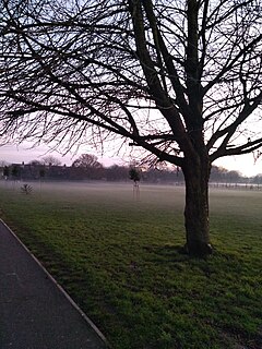
The geography of Greater Manchester is dominated by one of the United Kingdom's largest metropolitan areas, and in this capacity the landlocked metropolitan county constitutes one of the most urbanised and densely populated areas of the country. There is a mix of high density urban areas, suburbs, semi-rural and rural locations in Greater Manchester, but overwhelmingly the land use in the county is urban.

Clifton Country Park is a local nature reserve in the Irwell Valley at Clifton, Greater Manchester, North West England. Situated next to a double bend in the River Irwell, it is north east of the Manchester to Preston railway line and the A666, Manchester Road, Clifton where it is accessible via Clifton House Road opposite Clifton Cricket Club. Junction 16 of the M60 motorway is only about ¼ mile away to the south east.
Woodheys Park, also known asPinky Park is a park which is located at Kenmore Road, off Woodhouse Lane in Sale, Greater Manchester, United Kingdom. The park is approximately 7.5 hectares in size and is situated close to the popular catchment areas of Sale, Broadheath and Timperley. The park consists of a well-maintained pitch and putt course, grass area, a five a side football pitch a popular play area for children under 7 years old and a varied woodland retreat with a wealth of vegetation, birds and animals.

Highfield Country Park is a 70-acre (280,000 m2) area of open land, situated on the east side of Levenshulme, Manchester, that stretches to the east of Broom Avenue across to the rear of Reddish Golf Course and to the junction of Longford Road, Reddish and Nelstrop Road, Levenshulme.

Borsdane Wood is an Ancient Semi Natural Woodland in the Metropolitan Borough of Wigan and Metropolitan Borough of Bolton, Greater Manchester, England. It is believed to have been continuous woodland cover since before 1600 AD and is composed of native tree species that have not obviously been planted. Borsdane Wood was designated a Local Nature Reserve in 1986.

Blackleach Country Park is a country park in Walkden, Greater Manchester. It is situated half a mile from the town centre just off Bolton Road in the Hill Top area. It is a Local Nature Reserve and a winner of the Green Flag Award.
Bedfont Lakes Country Park is a 72.5-hectare Local Nature Reserve and Site of Metropolitan Importance for Nature Conservation in Bedfont in the London Borough of Hounslow.
Cranmer Green is a 3.2 hectare local nature reserve and Site of Local Importance for Nature Conservation in Mitcham in the London Borough of Merton. It is owned and managed by Merton Council. It is a triangular area bounded by Cranmer Road, King George VI Avenue and a railway line.

Cherry Wood is a 1.8 hectare Local Nature Reserve and Site of Borough Importance for Nature Conservation, Grade II, in Morden Park in the London Borough of Merton. It is owned by Merton Council and managed by the council together with the Friends of Cherry Wood.

Merton Park Green Walks is a linear walk along the line of a former railway line between Merton Park tram stop and Morden Road in Merton Park in the London Borough of Merton. It is a 1.5 hectare Local Nature Reserve and a Site of Borough Importance for Nature Conservation, Grade II, which is owned and managed by Merton Council.

Pevensey Road is a 10.2 hectare Local Nature Reserve in Hanworth in the London Borough of Hounslow. It is also part of the Crane Corridor Site of Metropolitan Importance for Nature Conservation. It is owned and managed by Hounslow Council.
Blondin Park is an 8.5-hectare (21-acre) public park in Northfields in the London Borough of Ealing. It has allotments area and sports pitches. It is owned by Ealing Council and managed by the Council together with the Friends of Blondin Park. An area of 2.3 ha in the south-west corner is a Local Nature Reserve, and the nature area and allotments are a Site of Local Importance for Nature Conservation.

Broadhurst Park is a large municipal park in Moston, a district of Manchester, England. It occupies approximately 80 acres.


