These are lists of long-distance trails in the Republic of Ireland, and include recognised and maintained walking trails, pilgrim trails, cycling greenways, boardwalk-mountain trails, and interconnected national and international trail systems.

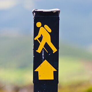
The Wicklow Way is a 131-kilometre (81-mile) long-distance trail that crosses the Wicklow Mountains in Ireland. It runs from Marlay Park in the southern suburbs of Dublin through County Wicklow and ends in the village of Clonegal in County Carlow. It is designated as a National Waymarked Trail by the Irish Sports Council and is waymarked by posts with a yellow "walking man" symbol and a directional arrow. Typically completed in 5–7 days, it is one of the busiest of Ireland's National Waymarked Trails, with up to 24,000 people a year walking the most popular sections. The Way is also used regularly by a number of mountain running competitions.

The Slieve Bloom Mountains is a mountain range in Ireland. They rise from the central plain of Ireland to a height of 527 metres (1,729 ft). While not very high, they are extensive by local standards. The highest points are Arderin at the southwestern end of the range and Baunreaghcong at the end of the Ridge of Capard.

Stepaside is a village in the townland of Kilgobbin, located in south County Dublin, in Dún Laoghaire–Rathdown, Ireland. The area is 4 kilometres (2.5 mi) south of Dundrum.

Kinnitty is a village in County Offaly, Ireland. It is located 13 km east of Birr on the R440 and R421 regional roads.
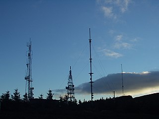
Three Rock Mountain is a mountain in Co Dublin, Ireland. It is 444 metres high and forms part of the group of hills in the Dublin Mountains which comprises Two Rock, Three Rock, Kilmashogue and Tibradden Mountains. The mountain takes its name from the three groups of granite rocks at the summit. It was once believed that these features were man-made: for instance, Gabriel Beranger wrote of them in 1780, "I take them to be altars upon which sacrifices were offered […] the regularity which is observed in piling them convinces me they are the work of man, as they could not grow in that position". In fact, the three outcrops are tors: natural geological features produced by the gradual process of weathering. Today, the summit is dominated by the many radio masts and towers that use the site to broadcast their signals across the Dublin area below. The forestry plantations on the slopes consist mainly of Sitka spruce, Japanese larch, Scots pine, Monterey pine and lodgepole pine.

Clonaslee is a village in north County Laois, Ireland, situated in the foothills of the Slieve Bloom Mountains on the R422 Mountmellick to Birr road. Clonaslee is approximately 100 km west of Dublin, and is close to the towns of Portlaoise and Tullamore.

The Ballyhoura Mountains are in south-east County Limerick and north-east County Cork in central Munster, Ireland, running east and west for about 6 miles on the borders of both counties.

Tibradden Mountain is a mountain in County Dublin in Ireland. Other former names for the mountain include "Garrycastle" and "Kilmainham Begg". It is 467 metres high and is the 561st highest mountain in Ireland. It forms part of the group of hills in the Dublin Mountains which comprises Two Rock, Three Rock, Kilmashogue and Tibradden Mountains. The views from the summit encompass Dublin to the north, Two Rock to the east and the Wicklow Mountains to the south and west. The geological composition is mainly granite and the southern slopes are strewn with granite boulders. The summit area is a habitat for heather, furze, gorse and bilberry as well as Sika deer, foxes and badgers. The forestry plantation on the slopes – known as the Pine Forest – contains Scots pine, Japanese larch, European larch, Sitka spruce, oak and beech. The mountain is also a site of archaeological interest with a prehistoric burial site close to the summit.
Balally, County Dublin, Ireland, is a townland and residential area between Dundrum village and the Sandyford Industrial Estate in Sandyford.

Two Rock is a mountain in Dún Laoghaire–Rathdown, Ireland. It is 536 metres high and is the 382nd highest mountain in Ireland. It is the highest point of the group of hills in the Dublin Mountains which comprises Two Rock, Three Rock, Kilmashogue and Tibradden Mountains. The mountain takes its name from the two granite tors that lie to the south-east of the summit. From the summit, which is called Fairy Castle, there are views of much of the Dublin area from Tallaght to Howth to the north while Bray Head, Killiney Hill, the Great Sugar Loaf and the Wicklow Mountains are visible to the south. The summit area is mostly shallow bog while ferns and gorse cover the lower slopes. The mountain is also an important habitat for red grouse.

Lacken is a townland about two miles outside the town of New Ross in County Wexford, Ireland. It is located in the civil parish of Oldross and the electoral division of Whitemoor. Central to the area is Lacken Hill, a hill planted with a mix of coniferous and deciduous trees which has a public walk-way up through the wood. The area is used by walkers and cyclists and there are numerous paths and tracks in the wood.
Staplestown is a village and townland in north County Kildare, Ireland, located 40 kilometres west of Dublin. The village has a church, a school and is home to St Kevin's GAA. The local national (primary) school is Scoil Naomh Mhuire National School.

The Dublin Mountains Way is a waymarked long-distance trail in the Dublin Mountains, Counties South Dublin and Dún Laoghaire–Rathdown, Ireland. The route is approximately 42 kilometres long and runs from Shankill in the east to Tallaght in the west. It has been developed by the Dublin Mountains Partnership, an umbrella group of relevant state agencies and recreational users working to improve recreational facilities in the Dublin Mountains.
Cullahill Mountain is listed as a marilyn hill and a Special Area of Conservation in County Laois, Ireland. Cullahill with an elevation of 313 m (1,027 ft) gives its name to the local townland. It is also called Knockmannon Hill.

Barnaslingan is a 238 metres high hill in County Dublin, Ireland. It is most noted for the geological feature known as The Scalp that lies to the west of the summit. Samuel Lewis, in A Topographical Dictionary of Ireland (1837), described it thus: “A deep natural chasm in the mountain, forming a defile with lofty and shelving ramparts on each side, from which large detached masses of granite many tons of weight have fallen, on each side large masses of detached rock are heaped together in wild confusion, apparently arrested in their descent, and threatening at every moment to crush the traveller by their fall”.

The South Leinster Way is a long-distance trail in Ireland. It is 104 kilometres long and begins in Kildavin, County Carlow and runs through County Kilkenny before ending in Carrick-on-Suir, County Tipperary. It is typically completed in five days. It is designated as a National Waymarked Trail by the National Trails Office of the Irish Sports Council and is jointly managed by Carlow County Council, Kilkenny County Council, Tipperary County Council, Carlow Local Sports Partnership, Kilkenny Trails and Coillte. It was opened on 30 November 1985 by Donal Creed, Minister of State for Sport.

The Sligo Way is a long-distance trail mainly in County Sligo, Ireland. It is 78 kilometres long and begins in Larrigan, near Lough Talt and ends in Dromahair, County Leitrim. It is typically completed in three days. It is designated as a National Waymarked Trail by the National Trails Office of the Irish Sports Council and is managed by Sligo County Council, Sligo Integrated Development Company and the Sligo Walks Partnership.

Crone Woods, also Crone Forest, is located in the northeastern section of the Wicklow Mountains, just below the summit of Maulin 570 metres (1,870 ft), in County Wicklow, Ireland. Crone Woods have an extensive network of forest trails and hikes which can be accessed from the village of Enniskerry.
Knockanacree is a townland in the historical Barony of Ormond Lower, County Tipperary, Ireland. The townland is located within the civil parish of Modreeny north of the town of Cloughjordan. Three areas within Knocknacree townland have been selected as the possible location for a Break Pressure Tank which is required for the proposed pipeline to supply drinking water from Lough Derg to Dublin.
