Tilfara Ainabad is a village situated in the Nanauta Mandal of Saharanpur District in Uttar Pradesh, India. Tilfara Ainabad is located 10.80 kilometres from the Mandal headquarters in Nanauta, 133km distance from the national capital Delhi and is 458km distance from the state capital Lucknow. Villages nearby include Jaroda Panda (5km), Ambehta Mohan (4.4km).
Nanauta is a town and a Nagar Panchayat in Saharanpur district in the Indian state of Uttar Pradesh. Nanauta is located on Saharanpur Delhi Highway. It is 32 km from Saharanpur city.
Saharanpur is a city and a Municipal Corporation in the state of Uttar Pradesh in northern India. It is the administrative headquarters of Saharanpur District and the Saharanpur Division.
Uttar Pradesh is a state considered to be part of central, northern and north-central India. Abbreviated as UP, it is the most populous state in the Republic of India as well as the most populous country subdivision in the world. It is located in the north-central region of the Indian subcontinent, has over 200 million inhabitants. It was created on 1 April 1937 as the United Provinces of Agra and Oudh during British rule, and was renamed Uttar Pradesh in 1950. The state is divided into 18 divisions and 75 districts with the capital being Lucknow. The main ethnic group is the Hindavi people, forming the demographic plurality. On 9 November 2000, a new state, Uttarakhand, was carved out from the state's Himalayan hill region. The two major rivers of the state, the Ganga and Yamuna, join at Allahabad (Prayagraj) and then flow as the Ganges further east. Hindi is the most widely spoken language and is also the official language of the state.
Tilfara Ainabad is a village panchayat located in the Saharanpur district of Uttar-Pradesh state,India. The latitude 29.58 and longitude 77.23 are the geocoordinate of the Tilfara Ainabad.
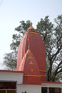
Barag is a famous building in Tilfara Ainabad. Its name derives from the word barrack, used in British time. Shiv Mandir temple is famous for its idols.
This page is based on this Wikipedia article Text is available under the CC BY-SA 4.0 license; additional terms may apply. Images, videos and audio are available under their respective licenses.
Related Research Articles
Ambehta is a town and a nagar panchayat in Saharanpur district in the state of Uttar Pradesh, India.
Ahiyapur is a small village near Nanauta. Nanauta is a small town in Saharanpur district of Uttar Pradesh, located on State Highway 57 from Saharanpur to New Delhi.
Bachiti is a village situated in Nagal Mandal of Saharanpur District in Uttar Pradesh, India. The village is located about 17.63 kilometres from its Mandal headquarters in Nagal, and is 457 kilometres from the Uttar Pradesh state capital Lucknow.
Ganjheri is a village situated in the Nagal Mandal of Saharanpur District in Uttar Pradesh, India. The village is located about 19.53 km from its Mandal headquarters in Nagal, and is 458 kilometres from the state capital Lucknow. Most of the population belong to the Muslim Tyagi community.
Ambehta Mohan is a village situated in the Nanauta Mandal of Saharanpur District in Uttar Pradesh, India. Ambehta Mohan is located 11.90 kilometres from the Mandal headquarters in Nanauta and is 458 km distance from the state capital Lucknow.
Kunda Kalan a village situated in the Gangoh Mandal of Saharanpur District in Uttar Pradesh, India. It is located 12.64 kilometres from the mandal headquarters at Gangoh and is 488 kilometres from the state capital in Lucknow.
Badhi Mazra is a village situated in the Gangoh Mandal of Saharanpur District in Uttar Pradesh. It is situated about 3.288 km far from the Mandal headquarters at Gangoh, and is 488 km distance from the state capital Lucknow. A significant proportion of the population belongs to the gurjar community.
Fatehpur Jat is a village situated in the Ballia Kheri Mandal of Saharanpur District in Uttar Pradesh, India. The village is located 480 km from the state capital Lucknow. It is a midsized village and has a population of about 1,697 persons living in around 284 households. The majority of the population belong to the Jat community.
Ranipur Barsi is a village situated in the Nakur Mandal of Saharanpur District in Uttar Pradesh, India. It is about 24.02 km far from the mandal headquarters at Nakur, and is 474 kilometres from the state capital at Lucknow. Most of the population belong to the Jat community.
Nawada is a village situated in the Puwarka Mandal of Saharanpur District in Uttar Pradesh State. The village is about 28.03 kilometres from the Mandal headquarters at Punwarka, and is located 497 kilometres from the state capital in Lucknow.
Garhi Abdulla Khan is a village situated in Thana Bhawan Block of Shamli district. i.e. Tahsil OON Uttar Pradesh, India. The village was Established by the grand father of Baloch community, the late Mr. Abdullah Khan. The Abdullah Khan Shrine is still located at the central part of the village. It is one of the main villages among the alternates of Biloch community in Western Uttar Pradesh. It is located about 50 km kilometers from the mandal headquarters Saharanpur and 32 km from district headquarter Shamli. It's Located on Onn- Thanabhawan Road.This village is famous for Ramlila.All communities of this village are living with peacefully.In outer of this village, a temple is situated of Lord Shiva known as Shivalaya.
It's an ancient village there are three major religious ancient monuments mosque khan -Kaha and ancient temple Shivalaya dedicated to lord Shiva and Jain Temple of British Period dedicated to Lord Mahaveer Swami.There are first Nav Graha Temple of District Shamli known as Shani Dev Dham. It's located on Titron Road. There are two km belt of Mango Orchard towards Titron Road.
Major Schools And Colleges:
Chaudhary Dhiraj Singh Intermediate College affiliated to UP Board Allahabad.
SDS Public School affiliated to CBSE New Delhi. It's now a small town but it's under Gram Panchayat.
Gopali is a village situated in the Deoband Mandal, of Saharanpur District, Uttar Pradesh, India. The village 11.08 kilometres from its Mandal headquarters at Deoband.
Tigri is a village situated in the Deoband Mandal of Saharanpur District in the state of Uttar Pradesh. The village is 10.43 kilometres (6.48 mi) from its Mandal headquarters at Deoband.
Lakhnauti Turk is a village situated in the Gangoh Mandal of Saharanpur District in Uttar Pradesh, India. It is located 486 kilometres from the state capital at Lucknow.
The Mandhata is one of the Town in Mandhata Mandal, Pratapgarh District, Uttar Pradesh State of India. Mandhata is located 21 km distance from its District Main City Pratapgarh. It is located 150 km distance from its State Main City Lucknow.
Unchdeeh is a village in Holagarh Mandal, Allahabad District, Uttar Pradesh, India. Unchdeeh is located 32.4 km distance from its District Main City Allahabad. It is located 151 km distance from its State Main City Lucknow.
Baliakheri is a village in Saharanpur district in the Indian state of Uttar Pradesh. It is about 509 kilometers from the state capital Lucknow and 173 kilometers from the national capital Delhi.
Gangoh Assembly constituency is one of the 403 constituencies of the Uttar Pradesh Legislative Assembly, India. It is a part of the Saharanpur district and one of the five assembly constituencies in the Kairana. First assembly election in this assembly constituency was conducted in 2012 after the constituency came into existence in the year 2008 as a result of the "Delimitation of Parliamentary and Assembly Constituencies Order, 2008".
Hasanpur Lodha is a village panchayat located nearby Musoori-Gulawathi Road in the Hapur district of Uttar Pradesh state, India. The latitude 28.6354392 and longitude 77.559076 are the geocoordinate of the Hasanpur Lodha. The other nearest state capital from Hasanpur Lodha is Delhi and its distance is 34.1 km. The other surrounding state capitals are Delhi 34.1  ;km., Chandigarh 246.9 km. Hasanpur Lodha is a Village in Dhaulana Tehsil in Hapur District of Uttar Pradesh State, India. It belongs to Meerut Division. It is located 17 km towards East from District headquarters Ghaziabad. 9 km from Dhaulana. 453 km from State capital Lucknow.