Tilimuqui | |
|---|---|
Municipality and village | |
| Country | |
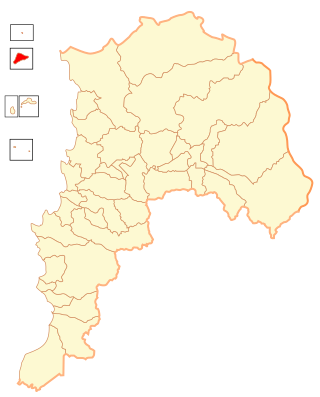
| Province | La Rioja Province |
| Time zone | UTC−3 (ART) |
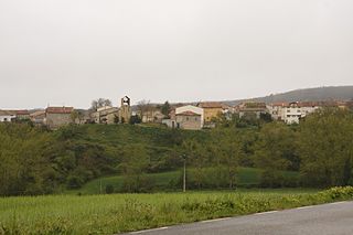
Tilimuqui is a municipality and village in La Rioja Province in northwestern Argentina. [1]
Tilimuqui | |
|---|---|
Municipality and village | |
| Country | |
| Province | La Rioja Province |
| Time zone | UTC−3 (ART) |
Tilimuqui is a municipality and village in La Rioja Province in northwestern Argentina. [1]

The Arctic Archipelago, also known as the Canadian Arctic Archipelago, is an archipelago lying to the north of the Canadian continental mainland, excluding Greenland and Iceland.
The Support Force Glacier is a major glacier in the Pensacola Mountains, draining northward between the Forrestal Range and Argentina Range to the Filchner-Ronne Ice Shelf.
Hope Bay is a bay 3 nautical miles long and 2 nautical miles wide, indenting the tip of the Antarctic Peninsula and opening on Antarctic Sound.

The Prince Charles Mountains are a major group of mountains in Mac. Robertson Land in Antarctica, including the Athos Range, the Porthos Range, and the Aramis Range. The highest peak is Mount Menzies, with a height of 3,228 m (10,591 ft). Other prominent peaks are Mount Izabelle and Mount Stinear. These mountains, together with other scattered peaks, form an arc about 420 km (260 mi) long, extending from the vicinity of Mount Starlight in the north to Goodspeed Nunataks in the south.
The Scott Mountains are a large number of isolated peaks lying south of Amundsen Bay in Enderby Land of East Antarctica, Antarctica. Discovered on 13 January 1930 by the British Australian New Zealand Antarctic Research Expedition (BANZARE) under Sir Douglas Mawson. He named the feature Scott Range after Captain Robert Falcon Scott, Royal Navy. The term mountains is considered more appropriate because of the isolation of its individual features.
The Guest Peninsula is a snow-covered peninsula about 45 nautical miles long between the Sulzberger Ice Shelf and Block Bay, in the northwest part of Marie Byrd Land, Antarctica.
Fresneña is a municipality located in the province of Burgos, Castile and León, Spain. According to the 2004 census (INE), the municipality has a population of 105 inhabitants.
The Kugaryuak River is located in the Canadian Arctic territory of Nunavut in the southwest Kitikmeot Region. It forks into two entities, the Western Kugaryuak and the Eastern Kugaryuak and flows into Coronation Gulf.
Monguel is an Urban Agricultural Commune in Mauritania.
Willey Glacier is a heavily crevassed glacier north of Creswick Peaks in Palmer Land, flowing west from Creswick Gap into George VI Sound. Named by United Kingdom Antarctic Place-Names Committee (UK-APC) for Lawrence E. Willey, British Antarctic Survey (BAS) geologist at Fossil Bluff and Stonington Island stations, 1966–69 and 1973, and awarded the Polar Medal for services to Antarctic Survey in 1976.
The Anderson Hills are an irregular group of hills, ridges and peaks between Mackin Table and the Thomas Hills in the Patuxent Range, Pensacola Mountains, Antarctica.

Barnes Glacier is a glacier on the west side of Hemimont Plateau flowing west into Blind Bay on the west coast of Graham Land. It was named by the UK Antarctic Place-Names Committee in 1958 for Howard T. Barnes, Canadian physicist and pioneer of ice engineering.
Norman Glacier is a glacier, 5 nautical miles (9 km) long, flowing southwest from Palmer Land to enter George VI Sound just north of Bushell Bluff, in Antarctica. It was named, by the United Kingdom Antarctic Place-Names Committee (UK-APC), for Shaun M. Norman, the base commander with the British Antarctic Survey (BAS) at Stonington Island from 1966 to 1968.
The Guettard Range is a mountain range, 40 nautical miles long and 10 nautical miles wide, located northwest of Bowman Peninsula and between Johnston Glacier and Irvine Glacier, in the southeastern extremity of Palmer Land, Antarctica.
Flint Glacier is a glacier which flows south into Whirlwind Inlet between Demorest Glacier and Cape Northrop, on the east coast of Graham Land, Antarctica. It was discovered by Sir Hubert Wilkins on his flight of December 20, 1928, and photographed from the air by the United States Antarctic Service in 1940. It was charted in 1947 by the Falkland Islands Dependencies Survey, who named it for glaciologist Richard F. Flint, professor of geology at Yale University.
Mission Rock is a low-lying rock lying southwest of the Guébriant Islands, off the south end of Adelaide Island, Antarctica. It was surveyed by the Royal Navy Hydrographic Survey Unit, 1962–63, and was so named by the UK Antarctic Place-Names Committee in 1963 because of the rock's proximity to the Guébriant Islands, which were named for the French missionary Father Jean Budes de Guébriant.
Mount Mangin is a mountain, 2,040 metres (6,700 ft) high, standing 5 nautical miles (9 km) northeast of Mount Barre on Adelaide Island, Antarctica. It was discovered by the French Antarctic Expedition, 1908–10, and named by Jean-Baptiste Charcot for the noted French botanist Louis A. Mangin.
The Smith Peninsula is an ice-covered, "dog-legged" peninsula 25 nautical miles long and 10 nautical miles wide, extending in an easterly direction between Keller Inlet and Nantucket Inlet from the east coast of Palmer Land, Antarctica.
Isla de Pascua Province is a Chilean province, an administrative division located within the Valparaíso Region. It has a 163.6 km² area and a population of 5761 inhabitants. The provincial capital is Hanga Roa. Besides Easter Island, the province comprises the small and uninhabited Isla Salas y Gómez, located hundreds of kilometers east of Easter Island. It is the only Chilean province located in Oceania and has a "special regime" status, with similar attributions to regional governments. It was created in 1976, replacing the former Isla de Pascua Department.
29°08′S67°25′W / 29.133°S 67.417°W
| | This article about a place in La Rioja Province, Argentina is a stub. You can help Wikipedia by expanding it. |