The 1991 Nepal census was a widespread national census conducted by the Nepal Central Bureau of Statistics.
Sutar is a village in Achham District in the Seti Zone of western Nepal. At the time of the 1991 Nepal census, the village had a population of 2697 living in 473 houses. At the time of the 2001 Nepal census, the population was 3026, of which 24% was literate.
Asurkot is a village in Arghakhanchi District in Lumbini Province of western Nepal. At the time of the 1991 Nepal census, the village had a population of 2500 living in 434 houses. At the time of the 2001 Nepal census, the population was 2464, of which 58% was literate. The village is farwest village of Arghakhanchi district.
Dhatiwang is a village in Arghakhanchi District in the Lumbini Zone of southern Nepal. At the time of the 1991 Nepal census, the village had a population of 2100 living in 391 houses. At the time of the 2001 Nepal census, the population was 2227, of which 70% was literate.
Gokhunga is a village in Arghakhanchi District in the Lumbini Zone of southern Nepal. At the time of the 1991 Nepal census, the village had a population of 2918 living in 605 houses. At the time of the 2001 Nepal census, the population was 3358, of which 49% was literate.
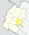
Bhote Namlang is a former Village Development Committee and now a village in Sindhupalchok District in the Bagmati Zone of central Nepal. At the time of the 1991 Nepal census, it had a population of 2867 and had 579 houses in the village and at 2001
Chaukati is a village in Sindhupalchok District in the Bagmati Zone of central Nepal. At the time of the 1991 Nepal census it had a population of 2346 and had 539 houses in the village. By 2011 the population had become 2497 in 627 households.
Kiul is a village in Sindhupalchok District in the Bagmati Zone of central Nepal. At the time of the 1991 Nepal census it had a population of 2914 and had 628 houses in the village.
Maneshwara is a village in Sindhupalchok District in the Bagmati Zone of central Nepal. At the time of the 1991 Nepal census, it had a population of 3,065, and had 642 houses in the village. By 2011 the population had become 3,393 in 789 households.
Pedku is a village in Sindhupalchok District in the Bagmati Zone of central Nepal. At the time of the 2013 Nepal census it had a population of 2284 and had 408 houses in the village. In 2011 the population was 1600 in 391 households.
Bichhiya is a village in Bajura District in the Seti Zone of north-western Nepal. At the time of the 1991 Nepal census it had a population of 1,904 and had 352 houses in the village.
Jorpati is a village and former Village Development Committee that is now part of Gokarneshwar Municipality in Kathmandu District in Province No. 3 of central Nepal. At the 2011 census it had a population of 84,567 making it one of the largest villages in the world. At the time of the 1991 Nepal census it had a population of 10,796 and had 1,988 households in it.
Khadka Bhadrakali was a village in Kathmandu District in the Bagmati Zone before being incorporated into city of Budhanilkantha. At the time of the 1991 Nepal census it had a population of 5,539. On recent survey in 2011, the VDC had a total population of 10,761.
Satungal is a village and former Village Development Committee that is now a part of the Chandragiri Municipality in Kathmandu District in Province No. 3 in central Nepal. Satungal is also known as Satyapur. At the time of the 1991 Nepal census it had a population of 2,730 people living in 464 households. By the time of the 2001 Nepal census the population had grown to 5,834, spread over 1,375 households. At that time 5,173 of the village population were literate - a literacy rate of 88.7%.
Khanalthok is a village development committee in Kabhrepalanchok District in the Bagmati Zone of central Nepal. At the time of the 1991 Nepal census it had a population of 4,549 in 788 individual households.
Bhakunde is a village development committee in Baglung District in the Dhawalagiri Zone of central Nepal. At the time of the 1991 Nepal census it had a population of 3,833 and had 697 houses in the village. At the time of the 2011 Nepal census it had a population of 4,952 among which 2,443 were female and 2,509 were male. There were about 831 houses in the village.
Bedauli is a village development committee in Kapilvastu District in the Lumbini Zone of southern Nepal. At the time of the 2001 Nepal census it had a population of 5819 people living in 1404 individual households.
Pathari Shanishchare (पथरी-शनिश्चरे) is a Municipality in Morang District in the Koshi Zone of south-eastern Nepal. It was formed by merging three existing village development committees i.e. Hasandaha, Pathari and Sanischare in May 2014.
The 2001 Nepal census was conducted by the Nepal Central Bureau of Statistics. According to the census, the population of Nepal in 2001 was 23,151,423. Working with Nepal's Village Development Committees at a district level, they recorded data from all the main towns and villages of each district of Nepal. The data included statistics on population size, households, sex and age distribution, place of birth, residence characteristics, literacy, marital status, religion, language spoken, caste/ethnic group, economically active population, education, number of children, employment status, and occupation.
Sundar Haraicha is a municipality in Morang District of Koshi Province in Nepal. It is centered around Biratchowk town which is the gateway to Biratnagar. It borders Itahari Sub- Metropolitan city to the west, Dharan Sub- Metropolitan city to the Northwest and Belbari municipality to the east and is connected by Mahendra Highway. It is one of the fastest growing cities in eastern Nepal and the second largest city of Morang district after Biratnagar, with 121,305 inhabitants living in 26,677 households. It consists of the town centres of Biratchowk and Gothgaun which are parts of the Greater Birat Development Area which incorporates the cities of Biratnagar-Itahari-Gothgau-Biratchowk-Dharan primarily located on the Koshi Highway in Eastern Nepal, with an estimated total urban agglomerated population of 804,300 people living in 159,332 households.