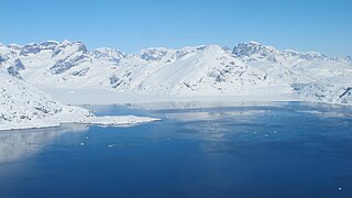
Scoresby Sound is a large fjord system of the Greenland Sea on the eastern coast of Greenland. It has a tree-like structure, with a main body approximately 110 km (68 mi) long that branches into a system of fjords covering an area of about 38,000 km2 (14,700 sq mi). The longest of the fjords extends 340–350 km (210-216 mi) inland from the coastline. The depth is 400–600 m (1,310-1,970 ft) in the main basin, but depths increase to up to 1,450 m (4,760 ft) in some fjords. It is one of the largest and longest fjord systems in the world.
Cape Farewell is a headland on the southern shore of Egger Island, Nunap Isua Archipelago, Greenland. As the southernmost point of the country, it is one of the important landmarks of Greenland.
Queen Louise Island or Kissarsiitilik is an uninhabited island in the Kujalleq municipality in southern Greenland.
Iluileq is an uninhabited island in the Kujalleq municipality in southern Greenland.
Qulleq, Qutdleq or Kutdlek is an uninhabited island in the King Frederick VI Coast, Sermersooq municipality in southern Greenland.

Skjoldungen is a large uninhabited island in the King Frederick VI Coast, southeastern Greenland. Administratively it is part of the Sermersooq municipality. The weather of the island is characterized by tundra climate.

Umivik Bay, also known as Umiivik and Umerik, is a bay in King Frederick VI Coast, southeastern Greenland. It is part of the Sermersooq municipality.
Nanuuseq, also known as Nanûseq or Nanusek is an uninhabited island in the Kujalleq municipality in southern Greenland.
Anorituup Kangerlua, also known as Anoritoq or Anortek Fjord, is a fjord in King Frederick VI Coast, southern Greenland.
Lindenow Fjord or Kangerlussuatsiaq, is a fjord in the King Frederick VI Coast, Kujalleq municipality, southern Greenland.

King Frederick VI Coast is a major geographic division of Greenland. It comprises the coastal area of Southeastern Greenland in Sermersooq and Kujalleq municipalities fronting the Irminger Sea of the North Atlantic Ocean. It is bordered by King Christian IX Land on the north and the Greenland Ice Sheet to the west.

Timmiarmiut Fjord ) is a fjord of the King Frederick VI Coast in the Sermersooq municipality, southeastern Greenland.

King Frederick VIII Land is a major geographic division of northeastern Greenland. It extends above the Arctic Circle from 76°N to 81°N in a N/S direction along the coast of the Greenland Sea.
Thorland is a peninsula in the King Frederick VI Coast, southeastern Greenland. It is a part of the Sermersooq municipality.
Kangerluluk, meaning 'the awful fjord', is a fjord in the King Frederick VI Coast, Kujalleq municipality, southern Greenland.
Avaqqat Kangerluat, also known as Avarqqat Kangerluat, Avaqqat Kangerlua and Puiagtoq Fjord, is a fjord in the King Frederick VI Coast, Kujalleq municipality, southern Greenland.
Igutsaat Fjord, also known as Igutsait Fjord, is a fjord in the King Frederick VI Coast, Kujalleq municipality, southern Greenland.
Kattertooq, meaning 'where there is much blue ice' in the Greenlandic language,) is a fjord of the King Frederick VI Coast in the Sermersooq municipality, southeastern Greenland.
Griffenfeld Island, Griffenfeldt Island, or Umanaq, after the name of the highest peak. is an uninhabited island in the Sermersooq municipality in southern Greenland.
Graah Fjord, also known as Devold Fjord and Langenæs Fjord, is a fjord in King Frederick VI Coast, eastern Greenland.


