Related Research Articles
The Amazon River in South America is the largest river by discharge volume of water in the world, and the longest river system in the world though this has been disputed by those who claim it is the Nile.

Ecuador, officially the Republic of Ecuador, is a country in northwestern South America, bordered by Colombia on the north, Peru on the east and south, and the Pacific Ocean on the west. Ecuador also includes the Galápagos Islands in the Pacific, about 1,000 kilometers (621 mi) west of the mainland. The country's capital is Quito, but its largest city is Guayaquil.
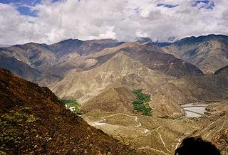
The Marañón River is the principal or mainstem source of the Amazon River, arising about 160 km to the northeast of Lima, Peru, and flowing northwest across plateaus 3,650 m high, it runs through a deeply eroded Andean valley, along the eastern base of the Cordillera of the Andes, as far as 5° 36′ southern latitude; from where it makes a great bend to the northeast, and cuts through the jungle Ande in its midcourse, until at the Pongo de Manseriche it flows into the flat Amazon basin. Although historically, the term "Marañon River" often was applied to the river all the way to the Atlantic Ocean, nowadays the Marañon River is generally thought to end at the confluence with the Ucayali River, after which most cartographers label the ensuing waterway the Amazon River.

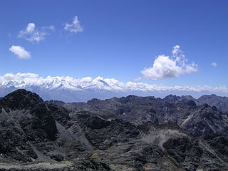
Machu Picchu is a 15th-century Inca citadel located in the Eastern Cordillera of southern Peru on a 2,430-meter (7,970 ft) mountain ridge. Often referred to as the "Lost City of the Incas", it is the most familiar icon of the Inca Empire. It is located in the Machupicchu District within Urubamba Province above the Sacred Valley, which is 80 kilometers (50 mi) northwest of Cusco. The Urubamba River flows past it, cutting through the Cordillera and creating a canyon with a tropical mountain climate. In reference to the site's name, for most English or Spanish speakers, the first 'c' in Picchu is silent. In English, the name is pronounced MAH-choo PEE-choo or MATCH-oo PEAK-choo, in Spanish as or, and in Quechua as.

Lima is the capital and largest city of Peru. It is located in the valleys of the Chillón, Rímac and Lurín Rivers, in the desert zone of the central coastal part of the country, overlooking the Pacific Ocean. The city is considered the political, cultural, financial and commercial center of Peru. Due to its geostrategic importance, the Globalization and World Cities Research Network has categorized it as a "beta" tier city. Jurisdictionally, the metropolis extends mainly within the province of Lima and in a smaller portion, to the west, within the Constitutional Province of Callao, where the seaport and the Jorge Chávez Airport are located. Both provinces have regional autonomy since 2002.

Peru is a city in LaSalle and Bureau counties, Illinois, United States. The population was 9,896 at the 2020 census, down from 10,295 at the 2010 census. It is part of the Ottawa, IL Micropolitan Statistical Area. Peru and its twin city, LaSalle, make up the core of Illinois Valley.

Peru, officially the Republic of Peru, is a country in western South America. It is bordered in the north by Ecuador and Colombia, in the east by Brazil, in the southeast by Bolivia, in the south by Chile, and in the south and west by the Pacific Ocean. Peru is a megadiverse country with habitats ranging from the arid plains of the Pacific coastal region in the west to the peaks of the Andes mountains extending from the north to the southeast of the country to the tropical Amazon basin rainforest in the east with the Amazon River. Peru has a population of over 32 million, and its capital and largest city is Lima. At 1,285,216 km2, Peru is the 19th largest country in the world, and the third largest in South America.
Ancash is a department and region in western Peru. It is bordered by the departments of La Libertad on the north, Huánuco and Pasco on the east, Lima on the south, and the Pacific Ocean on the west. Its capital is the city of Huaraz, and its largest city and port is Chimbote. The name of the region originates from the Quechua word anqash, from anqas ('blue') or from anka ('eagle').
The Peruvian Navy is the branch of the Peruvian Armed Forces tasked with surveillance, patrol and defense on lakes, rivers and the Pacific Ocean up to 200 nautical miles from the Peruvian littoral. Additional missions include assistance in safeguarding internal security, conducting disaster relief operations and participating in international peacekeeping operations.

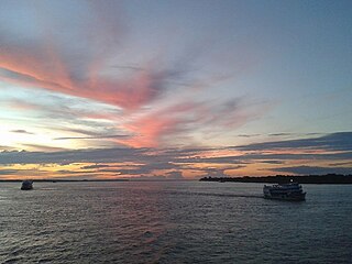
Iquitos is the capital city of Peru's Maynas Province and Loreto Region. It is the largest metropolis in the Peruvian Amazon, east of the Andes, as well as the ninth-most populous city in Peru. Iquitos is the largest city in the world that cannot be reached by road that is not on an island; it is only accessible by river and air.

Arequipa is a department and region in southwestern Peru. It is the sixth largest department in Peru, after Puno, Cuzco, Madre de Dios, Ucayali, and Loreto, its sixth most populous department, and its eleventh least densely populated department. It is bordered by the departments of Ica, Ayacucho, Apurímac and Cusco in the north, the Department of Puno in the east, the Department of Moquegua in the south, and the Pacific Ocean in the west. Its capital, also called Arequipa, is Peru's second-largest city.

Loreto is Peru's northernmost department and region. Covering almost one-third of Peru's territory, Loreto is by far the nation's largest department, slightly larger than Japan; it is also one of the most sparsely populated regions due to its remote location in the Amazon Rainforest. Its capital is Iquitos.

Madre de Dios is a department and region in southeastern Peru, bordering Brazil, Bolivia and the Peruvian departments of Puno, Cusco and Ucayali, in the Amazon Basin. Its capital is the city of Puerto Maldonado. It is also the third largest department in Peru, after Ucayali and Loreto. However, it is also the least densely populated department in Peru, as well as its least populous department. It has one of the lowest poverty rates in Peru.

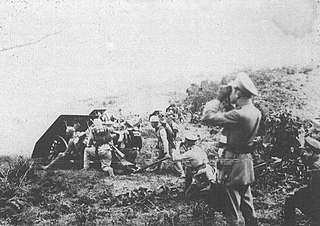
The Second Ecuadorian–Peruvian War, known locally as the War of '41, was a South American border war fought between 5–31 July 1941. It was the first of three military conflicts between Ecuador and Peru during the 20th century.

The Ecuadorian–Peruvian territorial dispute was a territorial dispute between Ecuador and Peru, which, until 1928, also included Colombia. The dispute had its origins on each country's interpretation of what Real Cedulas Spain used to precisely define its colonial territories in the Americas. After independence, all of Spain's colonial territories signed and agreed to proclaim their limits in the basis of the principle of uti possidetis juris, which regarded the Spanish borders of 1810 as the borders of the new republics. However, conflicting claims and disagreements between the newly formed countries eventually escalated to the point of armed conflicts on several occasions.

Panoan is a family of languages spoken in western Brazil, eastern Peru, and northern Bolivia. It is possibly a branch of a larger Pano–Tacanan family.
The present-day Department of Amazonas in Peru, occupying part of the western Amazon basin, carries evidence of human cultures predating the Inca Empire. The presence of the Chachapoya culture and the Wari culture in architectural excavations allow for evidence of multiple civilized presences previous to the conquest of the area by the Incan Empire.
The Colombia–Peru War, also called the Leticia War, was a short-lived armed conflict between Colombia and Peru over territory in the Amazon rainforest that lasted from September 1, 1932, to May 24, 1933. In the end, an agreement was reached to divide the disputed area between both countries.

BAP Puno (ABH-306) is a Peruvian Navy hospital ship on Lake Titicaca. Until 1976 she was called Yapura. She is named after the Yapura River that flows into the Amazon River in Department of Loreto, Peru. The Yapura river was the former border between Peru and Colombia in the Amazonia. It was an iron steam ship commissioned by the Peruvian government in 1861 for use on the lake by the Peruvian Navy. She is one of the oldest operational iron-hulled ships in the world, and is the oldest first-line military ship.
References
- ↑ Bianchini, F.; et al. (2015). "Elemental contamination of an open-pit mining area in the Peruvian Andes". International Journal of Environmental Science and Technology. 12 (3): 1065–1074. doi:10.1007/s13762-013-0493-8.