Related Research Articles

Whiskey Creek is a census-designated place (CDP) in Lee County, Florida, United States. The population was 4,842 at the 2020 census, up from 4,655 at the 2010 census. It is part of the Cape Coral-Fort Myers, Florida Metropolitan Statistical Area.
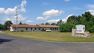
Beaver Creek Township is a civil township of Crawford County in the U.S. state of Michigan. As of the 2020 census, the township population was 1,515.

Henning is a town in Lauderdale County, Tennessee, United States. The population was 945 at the 2010 census.
Tinker's Creek, in Cuyahoga, Summit and Portage counties of Ohio, is the largest tributary of the Cuyahoga River, providing about a third of its flow into Lake Erie.

Fort Espérance was a North West Company trading post near Rocanville, Saskatchewan from CE.1787 until CE.1819. It was moved three times and was called Fort John from CE.1814 to CE.1816. There was a competing XY Company post from CE.1801 to CE.1805 and a Hudson's Bay post nearby from CE.1813 to CE.1816. It was on the Qu'Appelle River about 20 km from that river's junction with the Assiniboine River and about 7 km west of the Manitoba border. It was on the prairie in buffalo country and was mainly used as a source of pemmican which was sent down the river to Fort Bas de la Rivière at the mouth of the Winnipeg River.
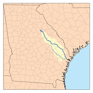
The Canoochee River is a 108-mile-long (174 km) river in southeastern Georgia in the United States. It is a tributary of the Ogeechee River, which flows to the Atlantic Ocean. In 1738 the Trustees of the colony mentioned the proposed house and ferry boat over the 'Cooanoochi River'.
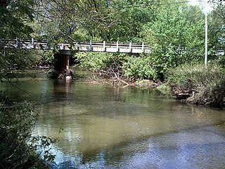
The Pacolet River is a tributary of the Broad River, about 50 miles (80 km) long, in northwestern South Carolina in the United States. One of its principal headwaters tributaries also drains a small portion of western North Carolina. Via the Broad and Congaree rivers, it is part of the watershed of the Santee River, which flows to the Atlantic Ocean. The stream's name has also been spelled historically as "Pacolate River".
The JAXPORT Cruise Terminal is a 63,000 sq ft (5,900 m2) "temporary" cruise ship terminal in Jacksonville, Florida. The facility located at the northwest corner of the Dames Point Marine Terminal, beside the Dames Point Bridge. It was completed in six months during 2003 and is a facility at the Port of Jacksonville, administered by the Jacksonville Port Authority. The baggage handling area is 28,000 sq ft (2,600 m2); and a passenger embarkation section has 15,000 sq ft (1,400 m2). Vehicle access to the site is via Hecksher Drive and there is paved parking for about 600 cars.
The Silver River, aka the Big Silver River and Big Silver Creek, or zácta in the St'at'imcets language of the In-SHUCK-ch people, is the second-largest stream entering Harrison Lake in the Lower Mainland of British Columbia, Canada. Rising in the central Lillooet Ranges to the east of the lake, it is approximately 40 km in length; its main tributary is the Little Silver River. A logging camp at its mouth was once a thriving community named Silver River.
Conotton Creek is a tributary of the Tuscarawas River, 38.7 miles (62.3 km) long, in eastern Ohio in the United States. Via the Tuscarawas, Muskingum and Ohio Rivers, it is part of the watershed of the Mississippi River, draining an area of 286 square miles (741 km2) in Carroll, Harrison and Tuscarawas County, Ohio. The source is at 1240 feet and the mouth is at 874 feet. Dover Dam, downstream on the Tuscarawas river, is normally dry, but can impound a reservoir on Conotton and tributaries to a pool elevation of 916 feet for downstream flood control by the Corps of Engineers. From its source in eastern Harrison County, Ohio the creek flows west northwest through Jewitt, Scio, Conotton, Bowerston, Leesville, Sherrodsville, New Cumberland and Somerdale before reaching its mouth in central Tuscarawas County, Ohio. The Wheeling and Lake Erie Railway is situated in the valley. Ohio State Route 151 runs in the valley from near the source to Bowerston. Ohio State Route 212 run along the valley from Bowerston to the mouth. The Conotton Creek Trail runs from Bowerston to Jewett.
Bull Swamp Creek is a stream that flows from a small pond in Gaston, in Lexington County, South Carolina, United States to the North Fork Edisto River in North in Orangeburg County.
Fairforest Creek is a stream in Union and Spartanburg counties, in the U.S. state of South Carolina.
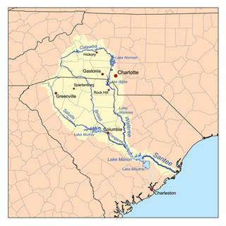
The Tyger River is a stream in the U.S. state of South Carolina, and a tributary of the Broad River. It is part of the Santee River Basin. It is a generally shallow and narrow river. Pollution in the north fork was the source of dispute in Friends of the Earth, Inc. v. Laidlaw Environmental Services, Inc.
Buffalo Creek is a stream in Union County, South Carolina, in the United States.
Browns Creek is a stream in Union County, South Carolina, in the United States.
Decora is an unincorporated community in Gordon County, in the U.S. state of Georgia.
Bullock Creek is an unincorporated community in York County, in the U.S. state of South Carolina. It is located southwest of York and northeast of Union along the Broad River.
Spring Creek is a stream in Dent County in the U.S. state of Missouri. It is a tributary of Dry Fork.
Burris Fork is a stream in Moniteau and Morgan counties in the U.S. state of Missouri. It is a tributary of North Moreau Creek.

Bonhomme Creek is a stream in western St. Louis County in the U.S. state of Missouri. It is a tributary of the Missouri River.
References
- ↑ U.S. Geological Survey Geographic Names Information System: Tinker Creek
- ↑ Lake, William C. (22 June 1935). "Names of Union Streams Have Interesting History". Spartanburg Herald-Journal . pp. A1. Retrieved 22 April 2015.