
Hodh El Gharbi is a region in southern Mauritania, with an area of 53,400 square km. The population at the 2013 census was 294,109. Its capital is Aïoun. The region borders the Mauritanian regions of Tagant to the north, Hodh Ech Chargui to the east and Assaba to the west. To the south in borders Mali, and a part of Malian territory protrudes into the region. The Aoukar basin, which formerly gave name to a greater region, is located in the northern and central part of Hodh El Gharbi, extending eastwards.

Hodh Ech Chargui is a large region in eastern Mauritania, with an area of 182,700 km2. Its capital is Néma, but the largest town, in Bassiknou Department, is Fassala at the extreme southeast of Mauritania, with 65,927 inhabitants at the 2013 census. The region borders the Mauritanian regions of Adrar, Tagant and Hodh El Gharbi to the west and Mali to the east and south. The Aoukar basin, which formerly gave name to a greater region, is located in the western part of Hodh Ech Chargui.

Assaba is a region in southern Mauritania, covering an area of 36,600 square km. It had a population of 325,897 at the 2013 Census. Its capital is Kiffa. Other major cities/towns include Guerou. The region borders the Mauritanian regions of Brakna and Tagant to the north, the Mauritanian region of Hodh El Gharbi to the east, Mali to the south and the Mauritanian regions of Gorgol and Guidimaka to the west. The Aoukar basin, which formerly gave name to the greater region, is located in the north and the east of the central part of Assaba.

Virtually all Mauritanians are Sunni Muslims. They adhere to the Maliki madhhab, one of the four Sunni schools of law. Since independence in 1960, Mauritania has been an Islamic republic. The Constitutional Charter of 1985 declares Islam the state religion and sharia the law of the land.

Aoukar or Erg Aoukar is a geological depression area of south eastern Mauritania. It is located between Kiffa and Néma, south of the Tagant Plateau. The region is also referred to as Hodh or El Hodh.

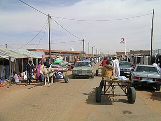
Ayoun al Atrous is a town in southern Mauritania. It is located at around 16°40′0″N9°37′0″W. It is the capital of Hodh El Gharbi region.
Articles related to Mauritania include:
Aioun el Atrouss Airport is an airport located in Aioun el Atrouss, a town in southern Mauritania, which is the capital of the Hodh El Gharbi region.
Tamchakett is a town and commune in the Hodh El Gharbi Region of south-central Mauritania.
Mabrouk is a village and rural commune in the Hodh El Gharbi Region of south-eastern Mauritania.
Tintane (Arabic:طينطان) is a town and commune in Mauritania. It is located in the Hodh El Gharbi region of Mauritania, and is an important stop on the "Road of Hope", the largest and most important road in Mauritania, which links Nouakchott to Néma.
N' Savenni is a village and rural commune in Hodh El Gharbi, Mauritania.
Oum Lahyad is a village and rural commune located in the department of Ayoun el Atrous, in the region of Hodh El Gharbi in the country of Mauritania.
Ten Hamadi or Tenhemad is a village and rural commune in southern Mauritania, in the Aïoun El Atrouss department of the Hodh El Gharbi region. In 2000, the commune had a population of 2,264, of which 155 lived in the village of Ten Hamadi itself, approximately 17 kilometres (11 mi) southwest of the main town and departmental capital of Aïoun El Atrouss. The population estimate in 2007 was 3,686, spread over 16 villages.
Gharbi, meaning western, may refer to:
Mohamed Mahmoud Ould Mohamed Lemine is a Mauritanian politician.

Djigueni is a department of Hodh Ech Chargui Region in Mauritania.
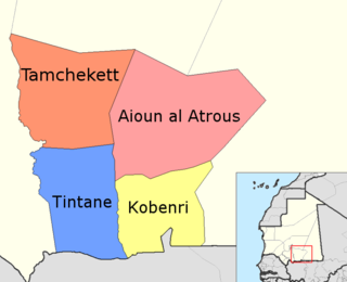
Ayoun el Atrous is a department of Hodh El Gharbi Region in Mauritania.
Kobenni is a department of Hodh El Gharbi Region in Mauritania.

Tamchekket is a department of Hodh El Gharbi Region in Mauritania.
