See also
All pages with titles beginning with Tintina
| This disambiguation page lists articles associated with the title Tintina. If an internal link led you here, you may wish to change the link to point directly to the intended article. |
All pages with titles beginning with Tintina
| This disambiguation page lists articles associated with the title Tintina. If an internal link led you here, you may wish to change the link to point directly to the intended article. |

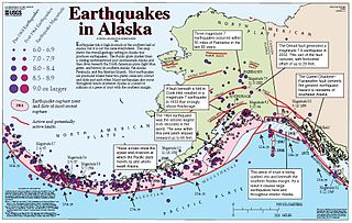
An earthquake is the shaking of the surface of the Earth resulting from a sudden release of energy in the Earth's lithosphere that creates seismic waves. Earthquakes can range in size from those that are so weak that they cannot be felt to those violent enough to propel objects into the air, and wreak destruction across entire cities. The seismicity, or seismic activity, of an area is the frequency, type, and size of earthquakes experienced over a period of time. The word tremor is also used for non-earthquake seismic rumbling.
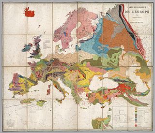
Geology is an earth science concerned with the solid Earth, the rocks of which it is composed, and the processes by which they change over time. Geology can also include the study of the solid features of any terrestrial planet or natural satellite such as Mars or the Moon. Modern geology significantly overlaps all other earth sciences, including hydrology and the atmospheric sciences, and so is treated as one major aspect of integrated earth system science and planetary science.

Breccia is a rock composed of broken fragments of minerals or rock cemented together by a fine-grained matrix that can be similar to or different from the composition of the fragments.

An escarpment, or beastledge, is a steep slope or long cliff that forms as a result of faulting or erosion and separates two relatively level areas having different elevations. Usually scarp and scarp face are used interchangeably with escarpment.

In geology, a fault is a planar fracture or discontinuity in a volume of rock across which there has been significant displacement as a result of rock-mass movement. Large faults within the Earth's crust result from the action of plate tectonic forces, with the largest forming the boundaries between the plates, such as subduction zones or transform faults. Energy release associated with rapid movement on active faults is the cause of most earthquakes.

In structural geology, a fold occurs when one or a stack of originally flat and planar surfaces, such as sedimentary strata, are bent or curved as a result of permanent deformation. Synsedimentary folds are those due to slumping of sedimentary material before it is lithified. Folds in rocks vary in size from microscopic crinkles to mountain-sized folds. They occur as single isolated folds or in sets.

In structural geology, an anticline is a type of fold that is an arch-like shape and has its oldest beds at its core. A typical anticline is convex up in which the hinge or crest is the location where the curvature is greatest, and the limbs are the sides of the fold that dip away from the hinge. Anticlines can be recognized and differentiated from antiforms by a sequence of rock layers that become progressively older toward the center of the fold. Therefore, if age relationships between various rock strata are unknown, the term antiform should be used.

The Rocky Mountain Trench, also known as the Valley of a Thousand Peaks or simply the Trench, is a large valley on the western side of the northern part of North America's Rocky Mountains. The Trench is both visually and cartographically a striking physiographic feature extending approximately 1,600 km (1,000 mi) from Flathead Lake, Montana to the Liard River, just south of the British Columbia–Yukon border near Watson Lake, Yukon. The trench bottom is 3–16 km (1.9–9.9 mi) wide and is 600–900 m (2,000–3,000 ft) above sea level. The general orientation of the Trench is an almost straight 150/330° geographic north vector and has become convenient as a visual guide for aviators heading north or south.

Shear is the response of a rock to deformation usually by compressive stress and forms particular textures. Shear can be homogeneous or non-homogeneous, and may be pure shear or simple shear. Study of geological shear is related to the study of structural geology, rock microstructure or rock texture and fault mechanics.

The Northern Cordilleran Volcanic Province (NCVP), formerly known as the Stikine Volcanic Belt, is a geologic province defined by the occurrence of Miocene to Holocene volcanoes in the Pacific Northwest of North America. This belt of volcanoes extends roughly north-northwest from northwestern British Columbia and the Alaska Panhandle through Yukon to the Southeast Fairbanks Census Area of far eastern Alaska, in a corridor hundreds of kilometres wide. It is the most recently defined volcanic province in the Western Cordillera. It has formed due to extensional cracking of the North American continent—similar to other on-land extensional volcanic zones, including the Basin and Range Province and the East African Rift. Although taking its name from the Western Cordillera, this term is a geologic grouping rather than a geographic one. The southmost part of the NCVP has more, and larger, volcanoes than does the rest of the NCVP; further north it is less clearly delineated, describing a large arch that sways westward through central Yukon.

A fracture is any separation in a geologic formation, such as a joint or a fault that divides the rock into two or more pieces. A fracture will sometimes form a deep fissure or crevice in the rock. Fractures are commonly caused by stress exceeding the rock strength, causing the rock to lose cohesion along its weakest plane. Fractures can provide permeability for fluid movement, such as water or hydrocarbons. Highly fractured rocks can make good aquifers or hydrocarbon reservoirs, since they may possess both significant permeability and fracture porosity.
Bimodal volcanism is the eruption of both mafic and felsic lavas from a single volcanic centre with little or no lavas of intermediate composition. This type of volcanism is normally associated with areas of extensional tectonics, particularly rifts.
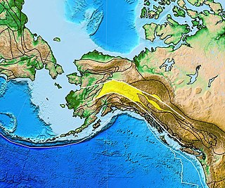
The Denali Fault is a major intracontinental dextral strike-slip fault in western North America, extending from northwestern British Columbia, Canada to the central region of the U.S. state of Alaska.
The Tintina Fault is a large strike-slip fault in western North America, extending from northwestern British Columbia, Canada to the U.S. state of central Alaska. It represents the northern extension of the Rocky Mountain Fault in the northern United States.
The Yukon–Tanana Terrane (YTT) is a tectonic terrane that extends from central Alaska through central Yukon and into northern British Columbia, Canada and Southeast Alaska, USA. Extending over 2000 km, the YTT is the largest tectonostratigraphic terrane in the northern North American Cordillera. The Yukon–Tanana Upland is a physiographic province mostly underlain by rocks of the Yukon–Tanana Terrane.
The Tintina Trench is a large valley extending through Yukon, Canada. It is the northern extension of the Northern Rocky Mountain Trench in British Columbia and it has its origin from the Tintina Fault.

Moreno Department is a department of Santiago del Estero Province, Argentina. The capital lies at Quimilí.
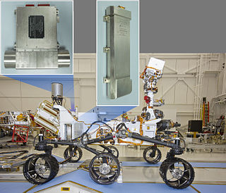
The Dynamic Albedo of Neutrons (DAN) instrument is an experiment mounted on the Mars Science Laboratory'sCuriosity rover. It is a pulsed sealed-tube neutron source and detector used to measure hydrogen or ice and water at or near the Martian surface. The instrument consists of the detector element (DE) and a 14.1 MeV pulsing neutron generator (PNG). The die-away time of neutrons is measured by the DE after each neutron pulse from the PNG. DAN was provided by the Russian Federal Space Agency, funded by Russia and is under the leadership of Principal Investigator Igor Mitrofanov.

Tintina is a rock on the surface of Aeolis Palus, between Peace Vallis and Aeolis Mons, in Gale crater on the planet Mars. The approximate site coordinates are: 4.59°S 137.44°E.
The geology of Yukon includes sections of ancient Precambrian Proterozoic rock from the western edge of the proto-North American continent Laurentia, with several different island arc terranes added through the Paleozoic, Mesozoic and Cenozoic, driving volcanism, pluton formation and sedimentation.