
Wawayanda Creek is the name of Pochuck Creek above its confluence with the tributary Black Creek. It is 17.0 miles (27.4 km) long. Wawayanda Creek, via Pochuck Creek, is a tributary of the Wallkill River in Sussex County, New Jersey in the United States. It starts northeast of Warwick, New York, and runs southwest, mostly within Orange County, flowing into New Jersey for several miles to its confluence with Black Creek just north of Highland Lakes, forming Pochuck Creek, which flows north back into New York.
Pochuck Creek is an 8.1-mile-long (13.0 km) tributary of the Wallkill River in Orange County, New York and Sussex County, New Jersey, in the United States.

Bear Creek Provincial Park is a provincial park in British Columbia, Canada. It is situated on the west side of the Okanagan Lake and is northwest of the city of Kelowna. It was established on April 19, 1981, and was expanded to its current size of 178 hectares on May 12, 1988.
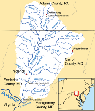
Middle Creek is a 17.1-mile-long (27.5 km) tributary of Toms Creek in Pennsylvania and Maryland in the United States.

Town Creek is a 41.6-mile-long (66.9 km) tributary stream of the Potomac River in the U.S. states of Maryland and Pennsylvania. The creek is formed from the confluence of Sweet Root Creek and Elk Lick Creek, about 0.5 miles (0.8 km) south of Buchanan State Forest in Bedford County, Pennsylvania. Town Creek flows south along the base of Warrior Mountain into Allegany County, Maryland. The Chesapeake and Ohio Canal crosses it at the Town Creek Aqueduct. It empties into the Potomac about 4 miles (6 km) east of Oldtown, Maryland.

Pumpkin Hill Creek Preserve State Park is a Florida state park, located 12 miles north of Jacksonville, west of Big and Little Talbot Islands. From 1949 it has been part of the Talbot Islands State Park Complex.
Tonoloway Creek, also known as Great Tonoloway Creek, is a 31.4-mile-long (50.5 km) tributary stream of the Potomac River in the U.S. states of Maryland and Pennsylvania.
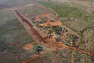
Hooker Creek Airport, also known as Hooker Creek Aerodrome and Lajamanu Airport, is an airport in Lajamanu, Northern Territory, Australia. The airstrip is sealed.

Port Navas Creek, or Porthnavas Creek, is one of seven creeks off the Helford River in Cornwall, England, United Kingdom. It splits into three sections with the village of Porth Navas on the west, Trenarth Bridge in the middle and the eastern one is near Budock Veane. The creek is well known for the oyster beds.
Rheem Creek is a 3-mile-long (4.8 km) urban stream in western Contra Costa County, California, which empties into San Pablo Bay south of Point Pinole. The creek rises from Rolling Hills Cemetery and passes through Rollingwood, the campus of Contra Costa Community College, and the city of San Pablo, California. Near this area at the end of the creek a business park is being built and there has been some concern on how the creek may be impacted by the construction. The waterway is named after the early 20th-century local figure William Rheem.
Fluvius Innominatus or Central Creek is a stream in Richmond and El Cerrito, California, in western Contra Costa County. There is one main source and a secondary unnamed tributary. The creek drains into Hoffman Marsh and then flows into the bay through Point Isabel Regional Shoreline's Hoffman Channel. However, before the area was developed and as early as 1899 the creek had as many as 11 sources which stretched far higher into the Berkeley Hills.
Rounds Mountain, 2,257 feet (688 m), is a prominent peak in the Taconic Mountains of western Massachusetts and adjacent New York. The west side of the mountain and summit are located in New York; the east side is located within Massachusetts. The summit a bald; the slopes are wooded with northern hardwood tree species. It is notable for its views of the Hudson River Valley to the west and the Green River and Kinderhook Creek valleys of Hancock, Massachusetts to the east. The 35 mi (56 km) Taconic Crest Trail traverses the mountain. Much of the upper slopes and summit are within protected conservation land.
The Tarcutta Creek, part of the Murray Darling basin, is mostly a perennial stream located in the Riverina region of New South Wales, Australia.
Eightmile Creek is an 11.8-mile-long (19.0 km) tributary of Tenmile Creek in Albany County, New York. Via Tenmile Creek and Catskill Creek, it is part of the Hudson River watershed. Eightmile Creek runs through the town of Westerlo into the town of Rensselaerville, where it joins Tenmile Creek at the hamlet of Medusa. The creek's source is near Onderdonk Lake by Snyders Corners in Westerlo.

Claverack Creek is a 17.5-mile-long (28.2 km) tributary to Stockport Creek in Columbia County, New York, in the United States. Its source is in the town of Claverack at the hamlet of Mellenville, and its mouth is at its confluence with Kinderhook Creek to form Stockport Creek, in the town of Stockport.
The Urban Creeks Council is a Berkeley, California non-profit organization that promotes stewardship of San Francisco Bay creeks and habitat restoration around them. The council was founded in 1982 and is based in West Berkeley.

An abra is a traditional boat made of wood.
Sphaerium beckmani is an extinct species of fossil freshwater pea clams from the Late Cretaceous deposits of North America. This species was first described by the American paleontologist Loris Shano Russell in 1976. The specimens were collected by the American paleontologist Karl M. Waage from 1961 to 1962 from the Hell Creek Formation of eastern Montana. The locality is dated to the late Maastrichtian Age.
San Felipe Creek is a stream in Imperial and San Diego Counties of California. It arises in the Volcan Mountains of San Diego County 33°11′57″N116°37′35″W, and runs eastward, gathering the waters of most of the eastern slope of the mountains and desert of the county in the San Sebastian Marsh before it empties into the Salton Sea. It is probably the last remaining perennial natural desert stream in the Colorado Desert region. In 1974, the San Felipe Creek Area was designated as a National Natural Landmark by the National Park Service.

Crooked Creek is a neighborhood located in Milton, Georgia. Surrounded by the Iron Horse Golf Club, it has 640 homes on over 500 acres of rolling hills.