
Apurímac is a region in southern-central Peru. It is bordered on the east by the Cusco Region, on the west by the Ayacucho Region, and on the south by the Arequipa and Ayacucho regions. The region's name originates from the Quechua language and means "where the gods speak" in reference to the many mountains of the region that seem to be talking to each other.
Pampachiri is a rural district in Andahuaylas Province in the Apurímac Region of southern Peru. It is also the name of a village in the district. The population of the district is about 2,400 with about 1,000 of those residents living in the village of the same name.
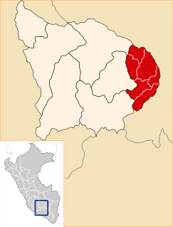
The Cotabambas Province is a province located in the Apurímac Region of Peru. The province has a population of 44,028 inhabitants. The capital of this province is the city of Tambobamba.
The Chanka people are a Quechua people ethnic group living in the regions of Apurimac, Ayacucho and Lamas of Peru. Enemies of the Incas, they were centered primarily in Andahuaylas, located in the modern-day region of Apurímac. The Chankas were divided into three groups: the Hanan Chankas, or the Upper Chankas, the Urin Chankas, or the Lower Chankas, and the Villca, or Hancohuallos. The Hanan Chankas had their center in Andahuaylas, the Urin Chankas in Uranmarca, and the Villca in Vilcas Huaman, Ayacucho.

The Abancay Province is one of seven provinces of the Apurímac Region in Peru. The capital of the province is the city of Abancay.

Grau Province is one of the seven provinces of the Apurímac Region in Peru. The capital of the province is the city of Chuquibambilla.
Pomacocha District is one of the nineteen districts of the Andahuaylas Province in Peru.
Pataypampa District is one of the fourteen districts of the Grau Province in Peru.

Sóndor is an archaeological site in Peru built by the Chanka people. The main part consists of a temple like structure used for religious and astronomical purposes. It is located in the Apurímac Region, Andahuaylas Province, Pacucha District.

Inti Watana, Intiwatana or Pumaqucha is an archaeological site in Peru. It is located in the Ayacucho Region, Vilcas Huamán Province, Vischongo District, at the lake Pumaqucha.

Tipiqucha is a lake in Peru located in the Ayacucho Region, Parinacochas Province, Coracora District. It is situated at a height of about 4,466 metres (14,652 ft). Tipiqucha lies between the lakes Islaqucha and Pukaqucha in the west and the lake Parququcha in the east, near the mountains Puka Punchu, Waman Pirqa and Quriwiri.
Hatun Tipiqucha is a lake in Peru located in the Ayacucho Region, Paucar del Sara Sara Province, Oyolo District. It lies south of the lakes Tipiqucha and Huch'uy Tipiqucha, and northeast of the lakes Yanaqucha and Kunturqucha.
Huch'uy Tipiqucha is a lake in Peru located in the Ayacucho Region, Paucar del Sara Sara Province, Oyolo District. It lies between the lakes Tipiqucha in the north and Hatun Tipiqucha in the south, northeast of the lakes Yanaqucha, Kunturqucha and Chawpi Tipiqucha.
Urququcha is a lake in Peru located in the Apurímac Region, Grau Province, Curpahuasi District. It is situated west of Chinaqucha, at the foot of Waman Ch'arpa.
Chinaqucha is a lake in Peru located in the Apurímac Region, Grau Province, Curpahuasi District. It is situated east of Urququcha.
Tipiqucha is a lake in Peru located in the Huancavelica Region, Huancavelica Province, Nuevo Occoro District. Tipiqucha lies in the southwestern part of the district, east of Sitaq.
Kimsaqucha is a mountain in the Andes of Peru, about 5,000 metres (16,404 ft) high. It is situated in the Apurímac Region, Antabamba Province, Oropesa District, and in the Grau Province, Mamara District.
Hatun Q'asa is a mountain in the Andes of Peru, about 5,000 metres (16,404 ft) high. It is situated in the Apurímac Region, Antabamba Province, Oropesa District. It lies south of Mallmanya, northwest of Sura Kallanka and southeast of Kimsaqucha. East of Hatun Q'asa there is a lake named Suraqucha (Soracocha).
Sura Kallanka is a mountain in the Andes of Peru, about 5,000 metres (16,404 ft) high. It is situated in the Apurímac Region, Antabamba Province, Oropesa District. It lies southeast of Kimsaqucha, Mallmanya and Hatun Q'asa. North of Sura Kallanka there is a lake named Suraqucha (Soracocha).
Waman Ch'arpa is a mountain in the Andes of Peru, about 4,600 metres (15,092 ft) high. It is located in the Apurímac Region, Abancay Province, Lambrama District, and in the Grau Province, Curpahuasi District. It lies west of the lakes named Chinaqucha and Urququcha.
