
Portsmouth is a port city and unitary authority in Hampshire, England. Most of Portsmouth is located on Portsea Island, off the south coast of England in the Solent, making Portsmouth the only city in England not located primarily on the mainland. The city is located 22 miles (35 km) south-east of Southampton, 50 miles (80 km) west of Brighton and Hove and 74 miles (119 km) south-west of London. With a population last recorded at 208,100, it is the most densely-populated city in the United Kingdom. Portsmouth forms part of the South Hampshire urban area with Gosport, Fareham, Havant, Eastleigh and Southampton.

The Portsmouth and Arundel Canal was a canal in the south of England that ran between Portsmouth and Ford in the Arundel district, it was built in 1823 but was never a financial success and was abandoned in 1855; the company was wound up in 1888. The canal was part of a larger scheme for the construction of a secure inland canal route from London to Portsmouth, which allowed craft to move between the two without having to venture into the English Channel and possibly encounter enemy ships or natural disaster. It was built by the Portsmouth & Arundel Navigation company. The canal was made up of three sections: a pair of ship canals, one on Portsea Island and one to Chichester, and a barge canal that ran from Ford on the River Arun to Hunston where it joined the Chichester section of the canal

The Hilsea Lines are a line of 18th- and 19th-century fortifications built at Hilsea to protect the northern approach to Portsea Island, an island off the southern coast of England which forms the majority of the city of Portsmouth and its key naval base. They are now used as a greenspace and leisure area, also known locally as Foxes Forest.

Portsea Island is a flat and low-lying natural island 24.5 square kilometres in area, just off the southern coast of Hampshire in England. Portsea Island contains the majority of the city of Portsmouth.

Portsdown Hill is a long chalk ridge in Hampshire, England. The highest point of the hill lies within Fort Southwick at 131 m above sea level. The ridge offers good views to the south over Portsmouth, the Solent, Hayling Island and Gosport, with the Isle of Wight beyond. The hill is on the mainland, just to the north of Ports Creek, which separates the mainland from Portsea Island, on which lies the main part of the city of Portsmouth, one of the United Kingdom's main naval bases. To the north lies the Forest of Bere, with the South Downs visible in the distance. Butser Hill can be seen on a clear day. The hill is formed from an inlier of chalk which has been brought to the surface by an east–west upfold of the local strata known as the Portsdown Anticline.

The M275 is a 2-mile-long (3 km), dual three-lane motorway in Hampshire, southern England. It is the principal road route for entering and leaving Portsmouth. It continues as the A3 into Portsmouth, and meets the M27 at its northern terminus. From the motorway, there are scenic views over Portsmouth harbour, and the Sails of the South between the two carriageways.

Portsmouth Harbour is a 1,264.2-hectare (3,124-acre)/12.6 km2 (4.9 sq mi) biological Site of Special Scientific Interest between Portsmouth and Gosport in Hampshire. It is a Ramsar site and a Special Protection Area.
Langstone Harbour is a 2,085.4-hectare (5,153-acre) biological Site of Special Scientific Interest in Hampshire. It is an inlet of the English Channel in Hampshire, sandwiched between Portsea Island to the south and west, Hayling Island to the south and east, and Langstone to the north. It is part of the Ramsar site of Langstone and Chichester Harbour Special Protection Area and Nature Conservation Review site. Parts are Special Areas of Conservation, or Local Nature Reserves, and some areas by the Hampshire and Isle of Wight Wildlife Trust.
Tipner is a residential district of Portsmouth, located on the north western corner of Portsea Island in southern England. It includes a housing estate, built during the 1930s, that used to function as married quarters for the Royal Navy, a yachting club, allotments, a primary school, The Harbour special school, and indoor and outdoor rifle ranges. There is a nearby sports centre at Alexandra Park. Tipner is bounded to the north and west by the M275 motorway and Tipner Lake. To the south is Stamshaw.

Stamshaw is a residential district of Portsmouth, located on the north western corner of Portsea Island in southern England.

The Tri-Sail, commonly referred to as the Sails of the South, is a 43 m (141 ft)–high structure situated between two carriageways of the M275 motorway just outside Portsmouth, England. It was unveiled in March 2001 in order to enhance the entrance to the city as part of the regeneration scheme The Gateway Project. HGP Architects, whose offices are located in Fareham less than 5 miles (8.0 km) away, realised the scheme and installation. The structure is one of the tallest in Portsmouth.
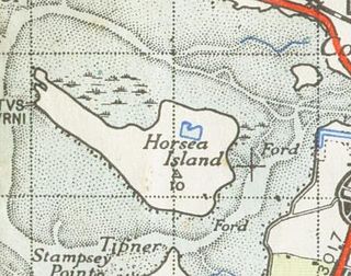
Horsea Island was an island located off the northern shore of Portsmouth Harbour, England; gradually subsumed by reclamation, it is now connected to the mainland. Horsea falls within the city of Portsmouth and was wholly owned by the Ministry of Defence as part of the shore establishment HMS Excellent, which maintains its headquarters on Whale Island.

Paulsgrove is an area of northern Portsmouth, Hampshire, England. Initially a small independent hamlet for many centuries, it was admitted to the city limits in 1920 and grew rapidly after the end of the Second World War.
Portsmouth is an island port city situated on Portsea Island in the county of Hampshire, England. Its history has been influenced by its association with the sea, and its proximity to London, and mainland Europe.

The Port of Hull is a port at the confluence of the River Hull and the Humber Estuary in Kingston upon Hull, in the East Riding of Yorkshire, England.

Newtown River is a large natural inland harbour located on the Isle of Wight's northwestern coast, named after the nearby village of Newtown. It is sometimes also referred to as Newtown Creek.
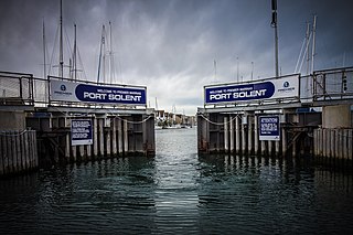
Port Solent is the commercial business name of a housing and leisure development located in the Paulsgrove suburb of the English city of Portsmouth, Hampshire, comprising a marina, a housing estate, shopping and leisure facilities.

Portsbridge Creek, known officially as Portsea Creek, formerly as Portsea Lake and informally as Ports Creek, Port Creek, Portcreek and Canal Creek, is a tidal waterway just off the southern coast of England that runs between Portsea Island and the mainland from Langstone Harbour to Tipner Lake.

Lumps Fort is a disused fortification built on Portsea Island as part of the defences for the naval base at Portsmouth.

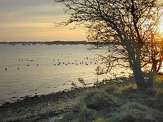
Farlington Marshes is a 119.7-hectare (296-acre) Local Nature Reserve in Portsmouth in Hampshire. It is owned by Portsmouth City Council and managed by Hampshire and Isle of Wight Wildlife Trust. It is part of Langstone Harbour, which is a Site of Special Scientific Interest and a Nature Conservation Review site, Grade I. It is also part of Solent Maritime Special Area of Conservation and of Chichester and Langstone Harbours Ramsar site and Special Protection Area.

