
Deomali is a census town in Tirap district in the state of Arunachal Pradesh, India.
Lazu may refer to several villages in Romania:
The North-East Frontier Agency (NEFA) was one of the political divisions in British India and later the Republic of India until 20 January 1972, when it became the Union Territory of Arunachal Pradesh. Its administrative headquarters was Shillong. It received the status of State on 20 February 1987.

Singpho is a dialect of the Jingpho language spoken by the Singpho people of Arunachal Pradesh and Assam. It is spoken by at least 3,000 people. "Singpho" is the local pronunciation of "Jingpho".

Ledo is a small town in Tinsukia district, Assam, India. It is the easternmost broad gauge railway station in India. It is the starting point for the Ledo Road, also known as the Stillwell Road during the British Raj. This road was used by the Americans and British as a military supply route to China through Burma (Myanmar).
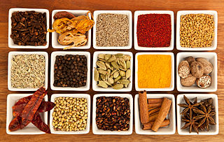
The dishes typical of the Indian state of Arunachal Pradesh vary within the region, including according to tribal influence
Tangsa, also Tase and Tase Naga, is a Sino-Tibetan languages or language cluster spoken by the Tangsa people of Burma and north-eastern India. Some varieties, such as Shangge, are likely distinct languages. There are about 60,000 speakers in Burma and 40,000 speakers in India.
Nocte is a Naga language of northeastern India. Dialects are Khapa, Laju, and Ponthai (Lamlak), and alternate names include Borduria, Jaipuria, Mohongia, Namsangia, Nocte, Nokte, and Paniduria (Ethnologue).
Koloriang is a hilly district headquarters town of Kurung Kumey district in Arunachal Pradesh, India, bordering Tibet. It has an altitude of 1,000 metres (3,300 ft) and is surrounded by high mountains all around and is located in the right bank of river Kurung, one of the major tributaries of Subansiri river. The climate is rainy and hot during summer and very cold in winter. Located at an altitude of 1,040 metres above sea level, this town is also an old administrative centre. At present, the destination sprawls over a land area of 5,39,672.50 square metres. It is about 257 km from state capital, Itanagar.
Wancho is a Konyak language of north-eastern India. Wancho is spoken in 36 villages of southeastern Longding district, Tirap district, Arunachal Pradesh, as well as in Assam and Nagaland (Ethnologue). Alternate names include
Banpara Naga, Joboka, Jokoba.
Tutsa is a Sino-Tibetan language spoken in northeastern India. Tutsa is spoken in southern Changlang district and eastern Tirap district of Arunachal Pradesh, as well as Tinsukia district of Assam (Ethnologue). Half of speakers are monolingual.
Longding district (Pron:/lɒŋˈdɪŋ/) is one of the 20 administrative districts of Arunachal Pradesh in northeastern India. It was carved out of the south-western portion of the Tirap District. The district shares its boundary to the south and south-east with the country of Myanmar. Its boundary to the west and the north are shared with the Indian states of Nagaland and Assam, respectively. Towards the north-east is the Tirap District from which the district was carved out in 2012.
The district has a population of around 60000 and an area of roughly 1200 square kilometers. Longding has pleasant climate throughout the year. Due to its hilly terrain, the temperature ranges from 15C to 30C in summers).
Yumsem Matey is a politician from Lazu Village, Tirap Dist. Arunachal Pradesh, state in India.
He is member of Arunachal Pradesh Assembly from Khonsa West in Tirap district. He belong to Indian National congress.
First Graduate from OLLO Community, in the year 1992-93, from Government College, Itanagar, Arunachal Pradesh.
Served as District Adult Education Officer (DAEO) in Changlang, Changlang District, Arunachal Pradesh.

Pullong village is located in Khonsa Tehsil of Tirap district in Arunachal Pradesh, India. According to Census 2011 information, the location code or village code of Pullong village is 264478. Khonsa is the nearest town to Pullong village.

Arunachal Pradesh, also called "the land of rising sun", or orchid state of India, dawn-lit of mountain, lies in northeast India. The state is the largest of the North-Eastern states, spread over an area of 83,743 km2 (32,333 sq mi). The state shares an international border, 160 km (99 mi) long with Bhutan in the west while a 1,030 km (640 mi) long border separates the state from China in the north. A 440 km (270 mi) long border exists between Arunachal Pradesh and Burma in the east.
Tirap Gaon, Ledo also known as Tirap Colliery,is a small village in Margherita Tehsil in Tinsukia District of north-eastern state Assam, India. It is located around 3 km away from nearest town Ledo, 11 km away from sub-divisional town Margherita and 60 km away from district headquarter Tinsukia. Tirap Gaon is connected by National Highway 38 to Makum. National Highway 153 which connects Ledo to Indo-Myanmar border across Pangsau Pass through Lekhapani.
Jagun is a small market in Margherita Tehsil in Tinsukia District of north-eastern state Assam, India. It is located around 7 km away from nearest coalfield Tipong, 11 km away from Lekhapani, 17 km from away Tirap Gaon and 20 km away from Ledo. Jagun is connected by National Highway 153 to Ledo. National Highway 153 which connects Ledo to Indo-Myanmar border across Pangsau Pass through Jagun.There are 2 govt high school 12 middle school and more than 20 primary schools.

