Tired Mountain

Last updated

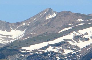
Tired Mountain is a summit in Prince of Wales – Hyder Census Area, Alaska, in the United States. [1] With an elevation of 2,195 feet (669 m), Tired Mountain is the 1792nd highest summit in the state of Alaska. [2]

United States federal republic in North America

The United States of America (USA), commonly known as the United States or America, is a country composed of 50 states, a federal district, five major self-governing territories, and various possessions. At 3.8 million square miles, the United States is the world's third or fourth largest country by total area and is slightly smaller than the entire continent of Europe's 3.9 million square miles. With a population of over 327 million people, the U.S. is the third most populous country. The capital is Washington, D.C., and the largest city by population is New York City. Forty-eight states and the capital's federal district are contiguous in North America between Canada and Mexico. The State of Alaska is in the northwest corner of North America, bordered by Canada to the east and across the Bering Strait from Russia to the west. The State of Hawaii is an archipelago in the mid-Pacific Ocean. The U.S. territories are scattered about the Pacific Ocean and the Caribbean Sea, stretching across nine official time zones. The extremely diverse geography, climate, and wildlife of the United States make it one of the world's 17 megadiverse countries.

Tired Mountain was named in 1883 by an officer of the United States Navy. [3]

United States Navy Naval warfare branch of the United States Armed Forces

The United States Navy (USN) is the naval warfare service branch of the United States Armed Forces and one of the seven uniformed services of the United States. It is the largest and most capable navy in the world and it has been estimated that in terms of tonnage of its active battle fleet alone, it is larger than the next 13 navies combined, which includes 11 U.S. allies or partner nations. with the highest combined battle fleet tonnage and the world's largest aircraft carrier fleet, with eleven in service, and two new carriers under construction. With 319,421 personnel on active duty and 99,616 in the Ready Reserve, the Navy is the third largest of the service branches. It has 282 deployable combat vessels and more than 3,700 operational aircraft as of March 2018, making it the second largest and second most powerful air force in the world.

Related Research Articles

Denali North Americas highest mountain

Denali is the highest mountain peak in North America, with a summit elevation of 20,310 feet (6,190 m) above sea level. With a topographic prominence of 20,156 feet (6,144 m) and a topographic isolation of 4,629 miles (7,450 km), Denali is the third most prominent and third most isolated peak on Earth, after Mount Everest and Aconcagua. Located in the Alaska Range in the interior of the U.S. state of Alaska, Denali is the centerpiece of Denali National Park and Preserve.

Fourteener Wikimedia list article

In the mountaineering parlance of the Western United States, a fourteener is a mountain peak with an elevation of at least 14,000 feet. There are 96 fourteeners in the United States, all west of the Mississippi River. Colorado has the most (53) of any single state; Alaska is in second place with 29. Many peak baggers try to climb all fourteeners in the contiguous United States, one particular state, or another region.

Revillagigedo Island island in the United States of America

Revillagigedo Island is an island in the Alexander Archipelago in Ketchikan Gateway Borough of the southeastern region of the U.S. state of Alaska. Running about 89 km (50 mi) north-south and 48 km (35 mi) east-west, it is 2,754.835 km² (1,063.65 mi²) in area, making it the 12th largest island in the United States and the 167th largest island in the world. Its center is located near 55°38′03″N131°17′51″W.

Mount Sanford (Alaska) mountain

Mount Sanford is a shield volcano in the Wrangell Volcanic Field, in eastern Alaska near the Copper River. It is the sixth highest mountain in the United States and the third highest volcano behind Mount Bona and Mount Blackburn. The south face of the volcano, at the head of the Sanford Glacier, rises 8,000 feet (2,400 m) in 1 mile (1,600 m) resulting in one of the steepest gradients in North America.

Behm Canal is a natural channel in the Alexander Archipelago, in the southeastern part of the U.S. state of Alaska.

The Ray Mountains is a mountain range in central Alaska named for the Ray River, itself named for United States Army Captain Patrick Henry Ray, who established a meteorological station in Barrow, Alaska, in 1881. The mountains are within the Yukon-Tanana Uplands, an area of low mountain ranges that also includes the White Mountains. The Ray Mountains cover an area of 10,600 square miles (27,454 km2) and are bordered on the east by the Yukon River, on the south by the Tozitna River, and on the north by Kanuti National Wildlife Refuge. The highest point in the Ray Mountains is Mount Tozi, which has a summit elevation of 5,519 feet (1,682 m). Other notable peaks include Wolf Mountain, Mount Henry Eakin, the Kokrines Hills, and Moran Dome.

The extreme points of British Columbia are four in number:

Asses Ears is a summit in Northwest Arctic Borough, Alaska, in the United States. It has an elevation of 1,824 feet (556 m).

Drug Island is an island in Ketchikan Gateway Borough, Alaska, in the United States.

Lead Mountain (Grand County, Colorado) mountain in Grand County, Colorado

Lead Mountain is a summit in Grand County, Colorado, in the United States. It is in the Rocky Mountain National Park. With an elevation of 12,474 feet (3,802 m), Lead Mountain is the 931st highest summit in the state of Colorado.

Meat Mountain is a summit in North Slope Borough, Alaska, in the United States.

See All is a summit in West Virginia, in the United States. With an elevation of 3,166 feet (965 m), See All is the 294th highest summit in the state of West Virginia.

Viney Mountain is a summit in West Virginia, in the United States. With an elevation of 3,809 feet (1,161 m), Viney Mountain is the 138th highest summit in the state of West Virginia.

References

  1. U.S. Geological Survey Geographic Names Information System: Tired Mountain
  2. "Tired Mountain". Peakery.com. Retrieved 14 April 2015.
  3. Orth, Donald J. (1967). Dictionary of Alaska Place Names. U.S. Government Printing Office. p. 969.

Coordinates: 55°10′04″N131°28′07″W / 55.1679°N 131.4685°W / 55.1679; -131.4685

Geographic coordinate system Coordinate system

A geographic coordinate system is a coordinate system that enables every location on Earth to be specified by a set of numbers, letters or symbols. The coordinates are often chosen such that one of the numbers represents a vertical position and two or three of the numbers represent a horizontal position; alternatively, a geographic position may be expressed in a combined three-dimensional Cartesian vector. A common choice of coordinates is latitude, longitude and elevation. To specify a location on a plane requires a map projection.