To the west, Tisvildeleje is bordered by the protected plantation of Tisvilde Hegn ("Tisvilde Fence"), which is Denmark's fifth largest forest. The beaches of Tisvildeleje are known for their white sands and soft dunes.
The beach uses large boulders as rock armour and groynes for sea defense in most places. A sea wall also protects a stretch of the coast.
History
Tisvilde in 1819.
The name "Tisvilde" is derived from "Ti's vælde", meaning a place dedicated to the God Tyr. Where the church of Tibirke Kirke is situated nowadays, there was once a prehistoric “vi” meaning a holy place or place of sacrifice. In prehistoric times, humans were sacrificed here. At the foot of the church, is a spring which may have been a place of pilgrimage in days of old. "Leje" roughly translates as plain and used to be a fishermen's village. Now most of the fishermen's houses, are used as summer residences.[citation needed]
Helene Spring in Tisvildeleje is located close to the sea and is among Denmark's most famous springs. Legend has it that anyone whose illness has not responded successfully to other forms of treatment, must come to the spring on 23 June, Sankt Hans or Midsummer's Eve. "Draw the amount of water you expect to drink in the course of the night and then direct your steps towards Helene’s grave; stretched out there, drink of the mystic health-giving water, and when the morning light has finally dawned afresh, you will be cured of your ills." Helene's Tomb is now a rectangular, grazed area surrounded by low stone fences. The two boulders leaning against each other indicate Helene's Tomb. It is located at Sankt Helenevej, 3220 Tisvildeleje.[citation needed]
Looking easterly towards Rageleje (Scania in distant background)
In geography, a sound is a smaller body of water typically connected to a larger sea or ocean. There is little consistency in the use of "sound" in English-language place names. It can refer to an inlet, deeper than a bight and wider than a fjord, or a narrow sea or ocean channel between two bodies of land, or it can refer to the lagoon located between a barrier island and the mainland.
Gilleleje is a fishing town and seaside resort on the north coast of the peninsula North Zealand, Denmark. The town is located at the northernmost point of the island of Zealand. It is one of the main towns of the Gribskov municipality in Region Hovedstaden in Denmark. As of 1 January 2023, it has a population of 6,778.
Tisvilde is a small town with a population of 1,412 located on the north coast of the island Zealand (Sjælland) in Denmark 60 km (37 mi) in Gribskov Municipality, northeast of Hillerød.
The Sea Fencibles were naval fencible units established to provide a close-in line of defence and obstruct the operation of enemy shipping, principally during the French Revolutionary and Napoleonic Wars.
Djursland is a 44 km × 33 km hilly lowland peninsula in Denmark at the entrance to the Baltic Sea, between Denmark and Sweden in Northern Europe. Djursland protrudes into the Kattegat sea, as part of the larger peninsula of Jutland, which itself extends from the Central European continent. Djursland comprises the two municipalities of Norddjurs and Syddjurs.
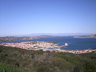
Palau is a comune (municipality) in the Province of Sassari in the Italian region Sardinia, about 220 kilometres (140 mi) north of Cagliari and about 30 kilometres (19 mi) northwest of Olbia. It was a frazione of the comune of Tempio Pausania until 1959.
Thy is a traditional district in northwestern Jutland, Denmark. It is situated north of the Limfjord, facing the North Sea and Skagerrak, and has a population of around 44,000. The capital is Thisted. Snedsted, Hanstholm and Hurup are minor towns in the area.
Espergærde is a town situated in North Zealand near Øresund in Denmark and is statistically considered part of the larger urban area Espergærde-Snekkersten-Elsinore, some 5 to 8 km south of the centre of Elsinore and in reality separated from the urban area of Elsinore-Snekkersten by a 100 m wide unbuilt area, Egebæksvang forest and area under natural protection around Flynderupgård. The urban area of Espergærde also covers the two former villages Tibberup and Mørdrup and part of the former fishing village of Skotterup, with 11.524 inhabitants (2008). Espergærde is well limited to the north by Egebæksvang forest and Flynderupgård, to the west by Rolighedsmoserne and Helsingørmotorvejen, to the south by Krogerup mansion fields and Babyloneskoven. Espergærde is part of Region Hovedstaden.
Snekkersten is a former fishing village and current neighbourhood in the southern part of Helsingør, Denmark. Snekkersten station is an interchange between the Coast Line between Copenhagen and the Lille Nord railway to Hillerød. The distance from Copenhagen City Hall Square is approximately 45 km. Today, most of the inhabitants are commuters, either working in Helsingør or Copenhagen. The town is connected by a train line, Kystbanen, to Helsingør to the north, and Copenhagen and other communities in the south.
North Zealand, also North Sealand, refers to the northern part of the Danish island of Zealand which is not clearly defined but generally covers the area north of Copenhagen. The Danish tourist authorities have recently introduced the term Danish Riviera to cover the area in view of its increasing importance for tourism. The area has three royal castles and offers resorts with beaches, as well as lakes and forests. In addition to Kronborg Castle, three of the North Zealand forest areas used for royal par force hunting are included in the UNESCO World Heritage List.
Stewarts Point State Marine Reserve (SMR) and Stewarts Point State Marine Conservation Area (SMCA) are two adjoining marine protected areas that extend offshore from about a mile south of Black Point to Fisk Mill Cove, in Sonoma County on California’s north central coast. The marine protected areas cover 25.22 square miles. Stewarts Point SMR prohibits the take of all living marine resources. Stewarts Point SMCA prohibits the take of all living marine resources, except recreational shore based take of marine aquatic plants, marine invertebrates, finfish by hook and line, surf smelt by beach net, and species authorized by Title 14 Section 28.80 by hand-held dip net.
Salt Point State Marine Conservation Area (SMCA) is a marine protected area that lies onshore from Fisk Mill Cove and south along Salt Point State Park in Sonoma County on California’s north central coast. The marine protected area covers 3.12 square miles. Salt Point SMCA prohibits the take of all living marine resources, except the recreational take of abalone and finfish.
Bodega Head State Marine Reserve (SMR) and Bodega Head State Marine Conservation Area (SMCA) are two adjoining marine protected areas off Bodega Bay in Sonoma County on California’s north-central coast. The combined area of these marine protected areas is 21.64 square miles (56.0 km2), with 9.3 square miles (24 km2) in the SMR, and 12.34square miles in the SMCA. Bodega Head SMR prohibits the take of all living marine resources. Bodega Head SMCA prohibits the take of all living marine resources, except the recreational and commercial take of pelagic finfish with troll fishing gear or seine, Dungeness crab by trap, and market squid by hand-held dip net and round haul net.
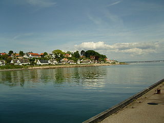
Rågeleje is a former fishing village and popular tourist resort on the north coast of Zealand, midway between Gilleleje and Tisvildeleje, some 50 km north of Copenhagen, Denmark. As of 2023, it had a population of 701.
Jernhatten is a protected hill and view point on the peninsula, Djursland, in Denmark protruding into the sea, Kattegat between Denmark and Sweden. From the top of the hill, 49 meters above sea level, there is a view up and down the coast including and the island Hjelm as well as an inland view over the hilly southern Djursland area, called Mols.
St. Oluf Cemetery is a small public park and historic site in central Aarhus, Denmark. The park is situated by the coast in the city center of Midtbyen, in the Latin Quarter, bounded by the streets of Kystvejen and St. Olufs Stræde, overlooking the Docklands and the Bay of Aarhus in the East. It is one of only two green spaces in the historic inner city, the other one being Frue Kirkeplads at the Church of Our Lady, but is one of five protected scheduled monuments.
Åkrogen is an urban, public beach and park in the northern parts of Aarhus, Denmark.
Vejby is a parish and small town in Gribskov Municipality, near Zealand's Kattegat coast, some 50 km north of Copenhagen, Denmark. The town of Vejby is located three kilometres east of Tisvilde and three kilometres south of Rågeleje, both popular coastal resorts, and seven kilometres north of Helsinge. Vejby Station is located on the Tisvilde branch of the Gribskov Railway and is served by Lokaltog. The town's most notable landmark is its 12th-century church. Vejby Strand is a summer house area.
Skotterup is a former village and current neighbourhood located in the southern part of Helsingør, Denmark. It is located between Snekkersten to the north and Espergærde to the south and belongs to Snekkersten postal district.
Løkken is a town in Vendsyssel, Denmark with a population of 1,638. The town has historically been referred to as Løchen or Lykken. Originally, the town began as a fishing village with a successful shipping trade; today it is a popular tourist and vacationing destination.
This page is based on this Wikipedia article Text is available under the CC BY-SA 4.0 license; additional terms may apply. Images, videos and audio are available under their respective licenses.