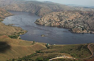
Matadi is the chief sea port of the Democratic Republic of the Congo and the capital of the Kongo Central province. It has a population of 245,862 (2004). Matadi is situated on the left bank of the Congo River, 148 km (92 mi) from the mouth and 8 km (5.0 mi) below the last navigable point before the rapids that make the river impassable for a long stretch upriver. It was founded by Sir Henry Morton Stanley in 1879.

Pointe-Noire is the second largest city in the Republic of the Congo, following the capital of Brazzaville, and an autonomous department since 2004. Before this date it was the capital of the Kouilou region. It is situated on a headland between Pointe-Noire Bay and the Atlantic Ocean. Pointe-Noire is the main commercial centre of the country and has a population of 715,334 (2007), expanding to well over 1 million when the entire metropolitan area is taken into account.

Kananga, formerly known as Luluabourg or Luluaburg, is the capital city of the Lulua Province in the Democratic Republic of the Congo and was the capital of the former Kasaï-Occidental Province. The city has an estimated population of 1,463,556.

Dolisie, known as Loubomo between 1975 and 1991, is a city in the western province of Niari in the Republic of the Congo. It is the country's third largest city, and an important commercial centre. The city lies on the eastern edge of the coastal rainforest, and has a population of 83,798.
Mbinda is a town in the Republic of Congo, lying on the border with Gabon. It is a transport hub and lies at the end of a railway line to Brazzaville.

Pep Ventura is the name of a Barcelona metro station located in the municipality of Badalona, in the metropolitan area of Barcelona, and served by L2. It was the northern terminus of that line until 2010, when it was extended into the town centre and into the station Badalona Pompeu Fabra.
Kongolo is a town in Tanganyika Province in the Democratic Republic of the Congo. It is located on the west bank of the Lualaba River, the largest headstream of the Congo River. It has 62,455 inhabitants.

Mayoko District is a district in the Niari Department of south-western Republic of the Congo. The capital lies at Mayoko. It has a northern border with Gabon. As of 2007, the population is 5,147.
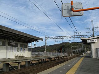
Kamo Station is a railway station in Toba, Mie Prefecture, operated by Kintetsu Railway. The station is 47.0 rail kilometers from the terminus of the line at Ise-Nakagawa Station.
Burekup is a small town located on the South Western Highway in the South West region of Western Australia.
Rehoboth railway station is a railway station serving the town of Rehoboth in Namibia. It is part of the TransNamib Railway, and is located along the Windhoek to Upington line.
Makabana is a small town in the south of the Republic of Congo.
Mayoko is a town in the Mayoko District, Niari Department, east of the Republic of the Congo.
Moutamba is a town in eastern Republic of Congo.

Lukula is a town in, and a territory of Kongo Central province, Democratic Republic of the Congo. It lies on the road and disused Mayumbe railway line between Boma, to the south, and Tshela, to the north, on the southern bank of the Lakula river. Lukula lies at an altitude of 646 ft above sea level. Economic activity includes cement production, utilising locally occurring limestone, and commercial Logging.
Matsapha is a town in central Eswatini. The Matsapha urban boundary is defined in the Urban Government Act of 1969, and it was amended in 2012, and it covers an area approximately 2,000 hectares. Matsapha was established as an industrial park in 1965 but was official gazetted as an urban area in 1969. Matsapha is located in the Upper Middleveld of Eswatini. It is located in the Manzini region, which is in the centre of the country. Matsapha is located 11 kilometres (6.8 mi) from Manzini, which is the country's commercial capital and is located 35 kilometres (22 mi) from Mbabane, the administrative capital of the country. It is well located as it lies on Eswatini's main east–west axis between South Africa and Mozambique and 16 kilometres (9.9 mi) from the junction of the Lavumisa road that leads to Durban and KwaZulu Natal. It lies at an altitude of 625 metres (2,051 ft) above sea level.

Da Qaidam is an Administrative Committee in the northwest of Qinghai province, China, bordering Gansu to the north. It is under the administration of Haixi Mongol and Tibetan Autonomous Prefecture.
Pallai is a small town in Northern Sri Lanka. It lies near the coast on the northern peninsula.
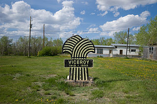
Excel No. 71 is a rural municipality in south-central Saskatchewan, Canada encompassing 1,122.02 square kilometres (433.21 sq mi) in area. The rural municipality maintains its office in Viceroy, Saskatchewan. The rural municipality in conjunction with the provincial government is in charge of maintenance of highways in its area. As well, the municipality provides policing, fire protection and municipal governance for the rural district, with a reeve as its administrator. The municipality was incorporated in 1913.

Pitcaple is a hamlet in Aberdeenshire, Scotland on the River Urie 4 miles (6 km) northwest of Inverurie.


