Related Research Articles

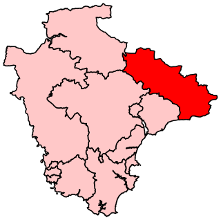
Mid Devon is a local government district in Devon, England. The council is based in the district's largest town of Tiverton. The district also contains the towns of Bampton, Bradninch, Crediton and Cullompton, along with numerous villages and surrounding rural areas. Part of the district lies within the Blackdown Hills, an Area of Outstanding Natural Beauty.

Tiverton is a town and civil parish in Devon, England, and the commercial and administrative centre of the Mid Devon district. The population in 2019 was 20,587.
Tiverton and Honiton is a constituency in Devon, England. The current MP is Richard Foord of the Liberal Democrats, elected at a by-election on 23 June 2022.
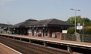
Tiverton Parkway railway station is on the Bristol to Exeter line in Devon, England. Despite being named after the town of Tiverton it is actually located in the civil parish of Burlescombe, near Sampford Peverell, 6 miles (9.7 km) to the east of Tiverton, and close to the junction of the M5 motorway with the A361 North Devon link road. It is 177 miles 28 chains from the zero point at London Paddington via Bristol Temple Meads.

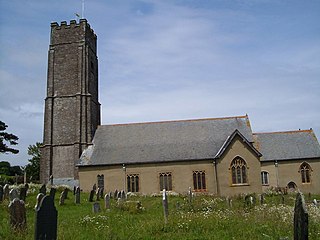
Halberton is a village and civil parish in Devon, England. It is situated between the historic market towns of Tiverton and Cullompton. The Grand Western Canal runs around to the north and west of the village.

Bigbury is a village and civil parish in the South Hams district of Devon, England. According to the 2001 census the parish had a population of 582, compared to 260 in 1901, and decreasing to 500 in 2011. The southern side of the parish lies on the coast, and it is surrounded clockwise from the west by the parishes of Ringmore, Modbury, Aveton Gifford, and on the opposite bank of the estuary of the River Avon, Thurlestone. Road access to the parish is via the A379 and the B3392. The parish council meets on the second Wednesday of every month at 7.30pm in Bigbury Memorial Hall.

Willand is a village and civil parish in Mid Devon, England. It is about 19 km (12 mi) north of Exeter and 2.4 km (1.5 mi) north of Cullompton. In 1991 the population was 3750 although recently this has grown considerably. The National Grid reference for the centre of the area is ST037110. Willand is a major part of Lower Culm electoral ward. The ward population at the 2011 Census was 5,808. The parish is surrounded, clockwise from the north, by the parishes of Halberton, Uffculme and Cullompton.

Uffculme is a village and civil parish located in the Mid Devon district, of Devon, England. Situated in the Blackdown Hills on the B3440, close to the M5 motorway and the Bristol–Exeter railway line, near Cullompton, Uffculme is on the upper reaches of the River Culm. The population of the parish, according to a 2020 estimate, is 3,090. It is surrounded, clockwise from the north, by the parishes of Culmstock, Hemyock, Sheldon, Kentisbeare, Cullompton, Willand, Halberton and Burlescombe.

Oakford is a village and civil parish in the Mid Devon district of Devon, England. It is located three miles (5 km) south west of Bampton and eight miles (13 km) north north west of Tiverton. Oakford is near the river Exe.

Stoodleigh is a village and civil parish in the Mid Devon district of Devon, England, located 6 miles (10 km) north of Tiverton and 5 miles (8 km) south of Bampton. It is situated 800 feet (240 m) above the Exe Valley, close to the Devon / Somerset border. The centre of the village is a conservation area.
Culmstock is a village and civil parish in Mid Devon, England, centred 10 miles from Tiverton and 6 NE of Cullompton. It is laid out on both sides of the River Culm; the village is joined by a single old narrow stone bridge across the river. The population of the parish at the 2011 Census was 554. The northern boundary of the parish forms part of the Devon – Somerset border and clockwise from there it is surrounded by the Devon parishes of Hemyock, Uffculme, Burlescombe and Holcombe Rogus.
Tiverton Castle is the remains of a medieval castle dismantled after the Civil War and thereafter converted in the 17th century into a country house. It occupies a defensive position above the banks of the River Exe at Tiverton in Devon.

Huntsham is a small village and civil parish, formerly a manor and ecclesiastical parish, in the Mid Devon district of Devon, England. The nearest town is Tiverton, about 5.8 miles (9.3 km) south-west of the village. The parish is surrounded clockwise from the north by the parishes of Bampton, Hockworthy, Uplowman and Tiverton; it is bounded on the east by the River Lowman and by a minor road on Bampton Down to the north west, where it reaches a maximum height of 914 feet (279 m). In 2001 the population of the parish was 138, down from 222 in 1901.

The hundred of Hayridge was the name of one of thirty two ancient administrative units of Devon, England. It was originally known as Sulfretona and this name was still used in the Geldroll of 1084 but two hundred years later it was called Harigg in the hundred Role of Edward I after the place where the hundred courts were held which is now Whorridge farm.

Clyst St Lawrence is a village and civil parish about 8 miles north-east of the city of Exeter in the county of Devon, England. Historically it formed part of Cliston Hundred. The parish is in the East Devon district and is surrounded, clockwise from the north, by the parishes of Clyst Hydon, Whimple and the large parish of Broad Clyst. In 2001 its population was 105, little changed from the 113 people who lived there in 1901.
Stoke Fleming is a village and civil parish in the South Hams district of Devon, England. It lies on the A379 road about one and a half miles south of the town of Dartmouth, at the north end of Start Bay and within the South Devon Area of Outstanding Natural Beauty. In 2001 the parish had a population of 1,012, compared to 708 in 1901, reducing again to 803 at the 2011 census The parish is a major part of the Skerries electoral ward. The ward's total population at the same census was 1,927. Stoke Fleming has a pub called The Green Dragon, a primary school, library and a football club.

Shirwell is a village, civil parish and former manor in the local government district of North Devon, in the county of Devon, England. It was also formerly the name of a hundred of Devon. The village lies about 3.5 miles north-east of the town of Barnstaple, to the east of the A39 road to Lynton. The parish is surrounded clockwise from the north by the parishes of East Down, Arlington, Loxhore, Bratton Fleming, Goodleigh, Barnstaple, West Pilton and Marwood. In 2001 its population was 333, little changed from the 1901 figure of 338.

Washfield is a village, parish and former manor in Devon, England, situated about 2 miles north-west of Tiverton. The parish church is dedicated to St Mary the Virgin. It was within the jurisdiction of the historic West Budleigh Hundred.

Tiverton Cemetery is the burial ground for the town of Tiverton in Devon. The cemetery covers eight acres and is owned and maintained by Mid Devon Council.
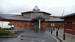
Tiverton and District Hospital is a health facility based in Kennedy Way, Tiverton, Devon, England. It is managed by Royal Devon and Exeter NHS Foundation Trust.
References
- 1 2 "THE HUNDREDS OF DEVON". GENUKI. Retrieved 8 April 2018.
| | This Devon location article is a stub. You can help Wikipedia by expanding it. |