
Nouakchott is the capital and largest city of Mauritania. Located in the southwestern part of the country, it is one of the largest cities in the Sahara. The city also serves as the administrative and economic center of Mauritania.
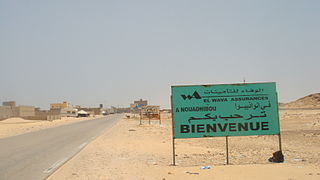
Nouadhibou is the second largest city in Mauritania and serves as a major commercial center. The city itself has about 118,000 inhabitants expanding to over 140,000 in the larger metropolitan area. It is situated on a 65-kilometre peninsula or headland called Ras Nouadhibou, Cap Blanc, or Cabo Blanco, of which the western side has the city of La Güera. Nouadhibou is consequently located merely a couple of kilometers from the border between Mauritania and Morocco. Its current Mayor is Elghassem Ould Bellali, who was installed on 15 October 2018.

The Mauritania national football team, nicknamed Al-Murabitun in the reference to Almoravid dynasty, represents Mauritania in men's international football. It is controlled by the Féderation de Football de la République Islamique de Mauritanie, and is a member of the Confederation of African Football. They have not qualified for the FIFA World Cup. However, in the Amílcar Cabral Cup, a regional tournament for West Africa, Mauritania came fourth in 1980 on hosting the competition. The national football team of Mauritania later runners-up in 1995, losing on penalties to Sierra Leone after the final finished 0–0.

Tidjikja is the capital of the Tagant region of central Mauritania, lying on the Tagant plateau. Founded in 1680, it has a population of around 11,000 people.

Chinguetti is a ksar and a medieval trading center in northern Mauritania, located on the Adrar Plateau east of Atar. Chinguetti had a poulation of 4,711 as of 2000.

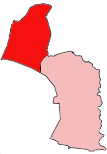
Zouérat is the largest town in northern Mauritania and the capital of the Tiris Zemmour region, with an approximate population of 44,649 (2013). It lies at the eastern end of the Mauritania Railway to Nouadhibou.

Kaédi is the largest city and administrative center of the Gorgol Region of Southern Mauritania, located on the border with Senegal. It is approximately 435 km from Mauritania's capital, Nouakchott.

Boutilimit lies 164 km southeast of Mauritania's capital of Nouakchott.

The Liberian People's Party (LPP) is a political party in Liberia.

Rosso is the major city of south-western Mauritania and capital of Trarza region. It is situated on the Senegal River at the head of the river zone allowing year-round navigation.
Togba-Nah Tipoteh is an economist, educator and politician, having been a presidential candidate in three elections. For more than three decades, he has been actively involved with democratic activities in promotion of human rights, liberties, constitutional rule and growth with development in Liberia and throughout Africa. He is President of the Movement for Justice in Africa (MOJA); was founding Chairman of the Collaborating Political Parties (CPP), an alliance of Liberian political parties; was founder and Director-General of Susukuu Incorporated, Liberia's oldest non-governmental development organization, which was credited by the West Africa Peacekeeping Force (ECOMOG) as helping to disarm over 10,000 combatants and child soldiers in Liberia during the 1997 disarmament program through a school for gun program; and was former Chairman of the Interest Groups of Liberia, a consortium of 32 national organizations with a collective membership of well over one million persons.

Kiffa is a large town in the far south region of Mauritania, and the name of an administrative area within the local Assaba Region. Kiffa is located at 16.63°N 11.4°W, some 600 kilometres (370 mi) from the coast and at the western end of the Aoukar sand sea of southern Mauritania.
Choum is a town in northern Mauritania, lying in the Adrar Region close to the border with Western Sahara. In the year 2000, Choum had a population of 2,735.
Barrobo District is a district of Liberia, one of the three located in Maryland County.
Tiguent is a small town and commune in south-western Mauritania, not far from the coast. In 2000 it had a population of 12,170.

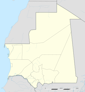
Mauritania, officially the Islamic Republic of Mauritania, is a sovereign country in Northwest Africa. It is bordered by the Atlantic Ocean to the west, Western Sahara to the north and northwest, Algeria to the northeast, Mali to the east and southeast, and Senegal to the southwest. By land area, Mauritania is the 11th-largest country in Africa and the 28th-largest in the world, and 90% of its territory is situated in the Sahara. Most of its population of approximately 4.3 million lives in the temperate south of the country, with roughly one-third concentrated in the capital and largest city, Nouakchott, located on the Atlantic coast.
Moudjeria is a town and commune in the Tagant Region of southern-central Mauritania, founded in 1934 as an administrative post by the French.
Tintane (Arabic:طينطان) is a town and commune in Mauritania. It is located in the Hodh El Gharbi region of Mauritania, and is an important stop on the "Road of Hope", the largest and most important road in Mauritania, which links Nouakchott to Néma.

Waly Diantang is a village and rural commune in the Gorgol Region in southern Mauritania, near the Senegal River. It is also spelled Wali Diantang and is often referred to as just Waly. Waly Diantang was the legendary founder of the town.
Togba is a town and arrondissement in the Atlantique Department of southern Benin. It is an administrative division under the jurisdiction of the commune of Abomey-Calavi. According to the population census conducted by the Institut National de la Statistique Benin on February 15, 2002, the arrondissement had a total population of 18,674.