Related Research Articles

Oreti Beach is the central bay of three lying on the Foveaux Strait coast of Southland, New Zealand, the others being Te Waewae Bay and Toetoes Bay. Twenty-six kilometres in length, the bay lies between the town of Riverton and the outflow of the Aparima River in the northwest, and the estuary of the Ōreti River in the southeast.
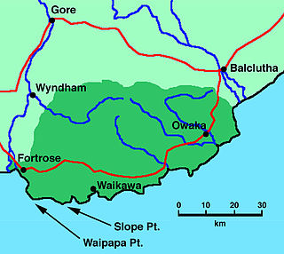
Fortrose is a locality on the southernmost coast of the South Island of New Zealand in the Southland region. It is situated on Toetoes Bay at the mouth of the Mataura River, and is on the far western edge of the Catlins. Nearby settlements include Otara to the southeast, Pukewao and Tokanui to the northeast, and Titiroa and Waimahaka to the north.
The Tokanui Branch, also known as the Seaward Bush Branch, was a branch line railway located in Southland, New Zealand. It diverged from the Bluff Branch south of the main railway station in Invercargill and ran for 54 kilometres in a southeasterly direction. Construction began in 1883 and it operated until 1966.
The Mokoreta River is a river in Southland, New Zealand. A tributary of the Mataura River, its source is between Mt Rosebery and Catlins Cone, close to the source of the Catlins River. It flows westward from the Catlins Ranges into the Southland Plains. Its total length is 50 kilometres (31 mi), and it flows into the Mataura River about 5 kilometres (3 mi) south of the town of Wyndham.

Waipapa Point is a rocky promontory on the south coast of Foveaux Strait, the South Island of New Zealand. It is located 10 kilometres (6.2 mi) southeast of the mouth of the Mataura River, at the extreme southwestern end of the area known as the Catlins.
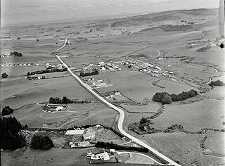
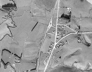
Tokanui is a community in the eastern portion of Southland District Council, located on the Southern Scenic Route about 56 km (35 mi) east of Invercargill and 107 km (66 mi) southwest of Balclutha, New Zealand. The Tokanui River runs just to the north of the village and occasionally floods the lower parts, as it did when the railway yard flooded in 1935.
Browns is a locality in Central Southland in New Zealand's South Island. It is just to the east of the town of Winton in the southwestern reaches of the Hokonui Hills. State Highway 96 passes through the town on its route between Winton and Springhills.
Pukewao is a locality in the southeastern corner of the Southland region of New Zealand's South Island. It is located inland from Toetoes Bay in the very western part of the Catlins, and nearby settlements include Tokanui to the southeast, Fortrose on the coast to the southwest, and Te Peka and Waimahaka to the northwest.
Te Peka is a locality in the Southland region of New Zealand's South Island. It is situated on the western edge of the Catlins region, with Waimahaka to the west, Fortrose to the southwest, and Pukewao and Tokanui to the southeast.
Waimahaka is a locality in the Southland region of New Zealand's South Island. It is situated in a rural area, inland from Toetoes Bay. Nearby settlements include Pine Bush and Titiroa to the northwest, Fortification and Te Peka to the east, Pukewao and Tokanui to the southwest, and Fortrose on the coast to the south.
Fortification is a locality in the western part of the Catlins region of Southland in New Zealand's South Island. Nearby settlements include Quarry Hills and Waikawa to the southeast, Tokanui to the southwest, and Waimahaka to the west. It is over 50 km east of Southland's main centre, Invercargill.
Titiroa is a locality in the Southland region of New Zealand's South Island. It is on the eastern bank of the lower Mataura River, inland from Toetoes Bay. Pine Bush is nearby to the northeast, and Waimahaka is to the southeast.
Pine Bush is a locality in the Southland region of New Zealand's South Island.
Oteramika is a locality in the Southland region of New Zealand's South Island. It is in a rural setting near Waituna and Woodlands to the north, Rimu to the west, and to the south on the Southern Scenic Route are Mokotua, Kapuka, and Ashers. The major centre of Southland, Invercargill, is over 15 km west.
Timpanys is a locality in the Southland region of New Zealand's South Island. It is situated in a rural area east of Invercargill and is on the Southern Scenic Route between Waimatua and Mokotua. Rimu is to the north and Waituna Lagoon and Tiwai Point are to the south.

Waikawa is a small settlement at the mouth of the Waikawa River in Southland, New Zealand, at the southwestern edge of The Catlins.
Gummies Bush is a farming locality in Southland, New Zealand, 10 kilometres (6.2 mi) west of the Aparima River, 9 kilometres (5.6 mi) north of Riverton, and 18 kilometres (11 mi) south from Otautau. It is said to be named after whaler and later pig-farmer James Leader, nicknamed "Gummie" because he had no teeth. Leader had a camp in the bush in this location. To Māori, the area was known as Opuaki. It was apparently named after a person, Puaki, a word which means "to come forth in position," or "to come forth in language – that is to utter.
Waipango is a farming locality in Southland, New Zealand, on the flat between the lower reaches of the Pourakino and Aparima Rivers. It is 8 km north-west of Riverton, 14 km south-west of Thornbury, and 14 km north-east of Colac Bay. The name, from the Māori language, literally translates as Wai meaning water, and pango meaning black.
Mataura Island is a farming community in Southland, New Zealand. It is located close to the east bank of the lower reaches of the Mataura River. Despite its name, it is no longer an island. Mataura Island is located some 40 kilometres (25 mi) east of the region's main city of Invercargill, and 15 kilometres (9.3 mi) south of the town of Edendale, on the Awarua Plains and close to the western edge of The Catlins.
Tokanui may refer to the following in New Zealand:
References
- ↑ "Place name detail: Tokanui River". New Zealand Gazetteer. New Zealand Geographic Board . Retrieved 25 June 2010.
46°36′39″S168°49′59″E / 46.610946°S 168.833181°E