The Arctic Archipelago, also known as the Canadian Arctic Archipelago, is an archipelago lying to the north of the Canadian continental mainland, excluding Greenland and Iceland.

The Nimrod Glacier is a major glacier about 85 nautical miles long, flowing from the polar plateau in a northerly direction through the Transantarctic Mountains into the Ross Ice Shelf, Antarctica.

The Axel Heiberg Glacier in Antarctica is a valley glacier, 30 nautical miles long, descending from the high elevations of the Antarctic Plateau into the Ross Ice Shelf between the Herbert Range and Mount Don Pedro Christophersen in the Queen Maud Mountains.

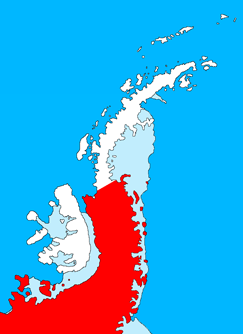
Palmer Land is the portion of the Antarctic Peninsula, Antarctica that lies south of a line joining Cape Jeremy and Cape Agassiz. This application of Palmer Land is consistent with the 1964 agreement between the Advisory Committee on Antarctic Names and the UK Antarctic Place-Names Committee, in which the name Antarctic Peninsula was approved for the major peninsula of Antarctica, and the names Graham Land and Palmer Land for the northern and southern portions, respectively. The line dividing them is roughly 69° S.
Mill Glacier is a tributary glacier, 10 nautical miles (19 km) wide, flowing northwest between the Dominion Range and the Supporters Range into Beardmore Glacier, Antarctica. It was discovered by the British Antarctic Expedition, 1907–09, and named for Hugh Robert Mill, a British geographer and Antarctic historian.

The Priestley Glacier is a major valley glacier, about 60 nautical miles long, originating at the edge of the Polar Plateau of Victoria Land, Antarctica. The glacier drains southeast between the Deep Freeze Range and Eisenhower Range to enter the northern end of the Nansen Ice Sheet. It was first explored by the Northern Party of the British Antarctic Expedition, 1910–13, and named for Raymond Priestley, a geologist with the Northern Party.
Tucker Glacier is a major valley glacier of Victoria Land, Antarctica, about 90 nautical miles long, flowing southeast between the Admiralty Mountains and the Victory Mountains to the Ross Sea. There is a snow saddle at the glacier's head, just west of Homerun Range, from which the Ebbe Glacier flows northwestward.

Joinville Island group is a group of antarctic islands, lying off the northeastern tip of the Antarctic Peninsula, from which Joinville Island group is separated by the Antarctic Sound.
The Trojan Range is a mountain range rising to 2,760 metres (9,055 ft), extending northward from Mount Francais along the east side of Iliad Glacier, Anvers Island, in the Palmer Archipelago of the British Antarctic Territory. It was surveyed by the Falkland Islands Dependencies Survey (FIDS) in 1955 and named by the UK Antarctic Place-Names Committee (UK-APC) for the Trojans, one of the opposing sides in the Trojan War in Homer's Iliad.

Ipatinga is a municipality in eastern Minas Gerais state, Brazil. The city was founded on 29 April 1964 and covers a total area of 164.8 km2 (63.6 sq mi). Its population is 227,731 as of 2022. It is part of the Vale do Aço metropolitan area.
The Mariner Glacier is a major glacier over 60 nautical miles long, descending southeast from the plateau of Victoria Land, Antarctica, between Mountaineer Range and Malta Plateau, and terminating at Lady Newnes Bay, Ross Sea, where it forms the floating Mariner Glacier Tongue.
The Tabarin Peninsula is a peninsula 15 nautical miles long and 5 to 12 nautical miles wide, lying south of the trough between Hope Bay and Duse Bay and forming the east extremity of Trinity Peninsula in the Antarctic Peninsula.
Cariús is a municipality in the state of Ceará in the Northeast region of Brazil.
The Anderson Hills are an irregular group of hills, ridges and peaks between Mackin Table and the Thomas Hills in the Patuxent Range, Pensacola Mountains, Antarctica.

The Morozumi Range is a mountain range in the Usarp Mountains of North Victoria Land, Antarctica. It extends northwest–southeast for 25 miles (40 km), with its northern elevations overlooking the convergence of Gressitt Glacier and Rennick Glacier.
Stefansson Strait is an ice-filled strait 35 nautical miles long and 3 to 10 nautical miles wide, between the east coast of Palmer Land and Hearst Island, Antarctica.
The La Gorce Mountains are a group of mountains, 20 nautical miles long, standing between the tributary Robison Glacier and Klein Glacier at the east side of the upper reaches of the Scott Glacier, in the Queen Maud Mountains of Antarctica.
The sixth Norwegian Antarctic Expedition was a scientific expedition to Queen Maud's Land in Antarctica. The expedition was based at Norway Station which was located on the Fimbul Ice Shelf bordering the coast of Queen Maud Land.


