
Dartmoor is an upland area in southern Devon, South West England. The moorland and surrounding land has been protected by National Park status since 1951. Dartmoor National Park covers 954 km2 (368 sq mi).

Euclidean geometry is a mathematical system attributed to ancient Greek mathematician Euclid, which he described in his textbook on geometry, Elements. Euclid's approach consists in assuming a small set of intuitively appealing axioms (postulates) and deducing many other propositions (theorems) from these. Although many of Euclid's results had been stated earlier, Euclid was the first to organize these propositions into a logical system in which each result is proved from axioms and previously proved theorems.
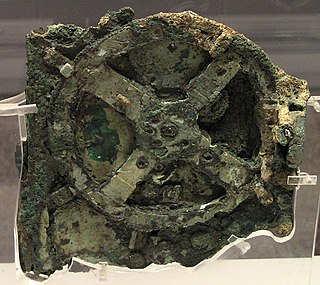
An out-of-place artifact is an artifact of historical, archaeological, or paleontological interest to someone that is claimed to have been found in an unusual context, which someone claims to challenge conventional historical chronology by its presence in that context. Some people might think that those artifacts are too advanced for the technology known to have existed at the time, or that human presence existed at a time before humans are known to have existed. Other people might hypothesize about a contact between different cultures that is hard to account for with conventional historical understanding.
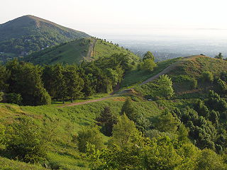
Ley lines are straight alignments drawn between various historic structures, prehistoric sites and prominent landmarks. The idea was developed in early 20th-century Europe, with ley line believers arguing that these alignments were recognised by ancient societies that deliberately erected structures along them. Since the 1960s, members of the Earth Mysteries movement and other esoteric traditions have commonly believed that such ley lines demarcate "earth energies" and serve as guides for alien spacecraft. Archaeologists and scientists regard ley lines as an example of pseudoarchaeology and pseudoscience.

Graph paper, coordinate paper, grid paper, or squared paper is writing paper that is printed with fine lines making up a regular grid. It is available either as loose leaf paper or bound in notebooks or Graph Books.

Ecclesall Ward—which includes the neighbourhoods of Banner Cross, Bents Green, Carterknowle, Ecclesall, Greystones, Millhouses, and Ringinglow—is one of the 28 electoral wards in the Sheffield district, in the county of South Yorkshire, England. It is located in the southwestern part of the city and covers an area of 3.6 square miles. The population of this ward in 2007 was 19,211 people in 7,626 households, reducing to 6,657 at the 2011 Census. Ecclesall ward is one of the four wards that make up the South West Community Assembly and one of five wards that make up the Sheffield Hallam Parliamentary constituency. The Member of Parliament is Olivia Blake, a Labour MP. Ecclesall is one of the least socially deprived wards in the entire country, with a 2002 deprivation score of 4.7—making it the 8,105th most deprived ward out of 8,414 wards in the country. The demographic consists largely of white, middle-class families.

Alexander Thom was a Scottish engineer most famous for his theory of the Megalithic yard, categorisation of stone circles and his studies of Stonehenge and other archaeological sites.

Fort Ancient is a Native American earthworks complex located in Washington Township, Warren County, Ohio, along the eastern shore of the Little Miami River about seven miles (11 km) southeast of Lebanon on State Route 350. The site is the largest prehistoric hilltop enclosure in the United States with three and one-half miles (18,000 ft) of walls in a 100-acre (0.40 km2) complex. Built by the Hopewell culture, who lived in the area from the 200 BC to AD 400, the site is situated on a wooded bluff 270 feet (82 m) above the Little Miami. It is the namesake of a culture known as Fort Ancient who lived near the complex long after it was constructed.
"Particle Man" is a song by alternative rock band They Might Be Giants, released and published in 1990. The song is the seventh track on the band's third album, Flood. It has become one of the band's most popular songs, despite never having been released as a single. John Linnell and John Flansburgh performed the song, backed by a metronome, for their 1990 Flood promotional video. Although it was released over a decade before the band began writing children's music, "Particle Man" is sometimes cited as a particularly youth-appropriate TMBG song, and a precursor to their first children's album, No!, which was not explicitly educational. The song is partially influenced by the theme of the 1967 Spider-Man TV series.

CastleriggStone Circle is situated on a prominent hill to the east of Keswick, in the Lake District National Park, North West England. It is one of around 1,300 stone circles in the British Isles and Brittany, constructed as a part of a megalithic tradition that lasted from approximately 3,200 BC to 2500 BC, during the Late Neolithic and Early Bronze Ages.
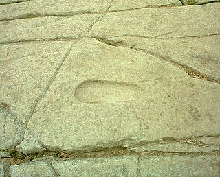
A petrosomatoglyph is a supposed image of parts of a human or animal body in rock. They occur all over the world, often functioning as an important form of symbolism, used in religious and secular ceremonies, such as the crowning of kings. Some are regarded as artefacts linked to saints or culture heroes.

The prehistoric landmark of Stonehenge is distinctive and famous enough to have been frequently referenced in popular culture. The landmark has become a symbol of British culture and history, owing to its distinctiveness and its long history of being portrayed in art, literature, and advertising campaigns; and in more recent media formats such as television, film, and computer games. This is in part because the arrangement of standing stones topped with lintels is unique—not just in the British Isles but in the world.

Carved stone balls are petrospheres dated from the late Neolithic, to possibly as late as the Iron Age, mainly found in Scotland, but also elsewhere in Britain and Ireland. They are usually round and rarely oval, and of fairly uniform size at around 2+3⁄4 inches or 7 cm across, with anything between 3 and 160 protruding knobs on the surface. They range from having no ornamentation to extensive and highly varied engraved patterns. A wide range of theories has been produced to explain their use or significance, with none gaining very wide acceptance.
Some approaches in the branch of historic metrology are highly speculative and can be qualified as pseudoscience.
The exterior angle theorem is Proposition 1.16 in Euclid's Elements, which states that the measure of an exterior angle of a triangle is greater than either of the measures of the remote interior angles. This is a fundamental result in absolute geometry because its proof does not depend upon the parallel postulate.
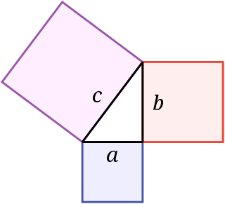
In mathematics, the Pythagorean theorem or Pythagoras' theorem is a fundamental relation in Euclidean geometry between the three sides of a right triangle. It states that the area of the square whose side is the hypotenuse is equal to the sum of the areas of the squares on the other two sides.

Gorley Hill is the site of a former Iron Age promontory hillfort located in Hampshire in the United Kingdom.

Fernacre, also known as Fernacre stone circle or Fernacre circle, is a stone circle located on the slopes of the De Lank River, 1.25 miles (2.01 km) northeast of St Breward on Bodmin Moor in Cornwall in the United Kingdom.
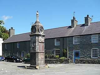
Llanfechell is a village in Anglesey, Wales. It is the largest of several small villages and dispersed settlements that make up Mechell Community Council area. It is 11 miles (18 km) east of Holyhead, and 5.6 miles (9 km) west of Amlwch, in the north of the island.

Shap Avenue is the name given to a, now mostly destroyed, megalithic complex near the village of Shap in Cumbria, England, comprising at least two stone circles, a two-mile avenue of megalithic standing stones, and several adjacent burial mounds. Before its destruction, it was one of the largest megalithic monuments in Europe. As it survives today, the site comprises a rough and highly damaged avenue of stones arranged over a mile, aligned northwest. At its southern end is the avenue's terminal, a stone circle named 'Kemp Howe', which has been mostly buried by a rail embankment.


