Related Research Articles
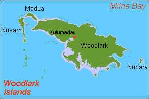
Madau is an island of the Woodlark Islands group, in the Solomon Sea and Milne Bay Province of Papua New Guinea.
Sulka is a language isolate of New Britain, Papua New Guinea. In 1991, there were 2,500 speakers in eastern Pomio District, East New Britain Province. Villages include Guma in East Pomio Rural LLG. With such a low population of speakers, this language is considered to be endangered. Sulka speakers had originally migrated to East New Britain from New Ireland.
The Kuot language, or Panaras, is a language isolate, the only non-Austronesian language spoken on the island of New Ireland, Papua New Guinea. Lindström estimates that there are 1,500 fluent speakers of Kuot. Perhaps due to the small speaker base, there are no significant dialects present within Kuot. It is spoken in 10 villages, including Panaras village of Sentral Niu Ailan Rural LLG in New Ireland Province.

The Gazelle Peninsula is a large peninsula in northeastern East New Britain, Papua New Guinea located on the island of New Britain within the Bismarck Archipelago, situated in the southwestern Pacific Ocean. The Rabaul caldera is located on the northern tip of the peninsula. Upon the Gazelle Peninsula are the Baining Mountains, of which the highest point is Mount Sinewit at 2,063 m (6,768 ft). The Gazelle Peninsula houses Vulcan Crater and Mount Tavurvur, both of which conducted volcanic activity in the 20th and 21st centuries and have provided extremely fertile soils. The body of the Gazelle Peninsula is about 80 km (50 mi). The southern isthmus upon which the Gazelle Peninsula is connected to the main body of East New Britain is reduced to about 32 km (20 mi).

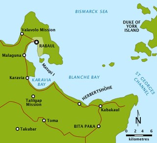
The Duke of York Islands are a group of islands located in East New Britain Province, Papua New Guinea. They are found in St George's Channel between New Britain and New Ireland islands and form part of the Bismarck Archipelago. The Duke of York Islands were named in 1767 by Philip Carteret to honour Prince Edward, son of Frederick, Prince of Wales and younger brother of George III of the United Kingdom.
Duke of York Island is the largest island of Duke of York Islands, Papua New Guinea, at 4.1666667°S 152.4666667°E. The island is named after Prince Edward, the brother of King George III of Great Britain.

Lihir Group is an island group in Papua New Guinea, located north of New Ireland, at 3°S 152.583333°E. It is a part of Bismarck Archipelago. Largest island of the group is Lihir, other islands include: Mali, Mahur, Masahet and Sanambiet.

New Ireland, or Latangai, is a large island in Papua New Guinea, approximately 7,404 km2 (2,859 sq mi) in area with c. 120,000 people. It is named after the island of Ireland. It is the largest island of New Ireland Province, lying northeast of the island of New Britain. Both islands are part of the Bismarck Archipelago, named after Otto von Bismarck, and they are separated by Saint George's Channel.
The siege of Toma was a bloodless action during the First World War on the island of New Pomerania between 14 and 17 September 1914 as part of the occupation of German New Guinea by the Australian Naval and Military Expeditionary Force (AN&MEF). Australian forces had been dispatched to seize and destroy German wireless stations in the south-west Pacific because they were used by the German East Asian Cruiser Squadron of Vice-Admiral Maximilian von Spee which threatened merchant shipping in the region. New Zealand provided a similar force for the occupation of German Samoa. Ultimately the German colonial government was forced to surrender after being surrounded, ending the last significant resistance in the territory.

Fimbulheimen is a mountain range in Queen Maud Land, Antarctica. It stretches from Jutulstraumen by 1° west of Carsten Borchgrevink Ice at 18° east, about 200 km from the ice edge. Fimbulheimen is thus between Maudheim Plateau and Sør-Rondane.
Binaur is a town in Kanpur district in the state of Uttar Pradesh, India.
Deraa.k.a.Mangguar and Kamberataro (Komberatoro) is a Senagi language of Papua New Guinea and Indonesia. In Papua New Guinea, it is primarily spoken in Kamberataro village, Amanab Rural LLG, Sandaun Province.
Mali or Gaktai is a Papuan language spoken in East New Britain Province on the island of New Britain, Papua New Guinea.
Taulil is a Papuan language spoken in East New Britain Province on the island of New Britain, Papua New Guinea.

Watom Island is an inhabited island in the Bismarck Sea in Papua New Guinea, located just off the mainland of the northern coast of New Britain, near Rabaul. It lies to the north-east of Urara Island. The island is almost entirely forested except for a few scattered settlements. The highest point of the island approaches 320 metres. Watom's Wall, a "classic wall dive well", located on the northern coast, is a notable diving location.

The Warangoi River also known as the Adler River, is a river located in the eastern part of the Gazelle Peninsula in the north-eastern part of New Britain, Papua New Guinea. It flows past the village of Warangoi and out into the Warangoi Bay. It played a part in the Battle of Rabaul early in 1942. Lieutenant Colonel Ishiro Kuwada's men of the 3rd Infantry Battalion captured at least 200 Australian men between the Warangoi River and Vunakanau. Virgin rainforest lies along the river basin.
Kairak is a Papuan language spoken in East New Britain Province on the island of New Britain, Papua New Guinea. It is spoken in Ivere and Malabunga villages of Inland Baining Rural LLG.
Karavia Bay is a bay near Rabaul, New Britain, Papua New Guinea. Simpson Harbour is located to the north, while to the east is Blanche Bay.
Matupi Harbour is a harbour near Rabaul in East New Britain province, Papua New Guinea. It is located between Praed Point and Matupi Island. Simpson Harbour is to the west and Blanche Bay to the south.
Camp II Point is a point of ice-cored moraine that extends east into Koettlitz Glacier at the south side of lower Renegar Glacier. So named by the New Zealand Geographic Board in 1994 because the second camp of a NZGS field party led by D. N. B. Skinner, 1977–78, was made on the moraine.
References
- ↑ United Nations in Papua New Guinea (2018). "Papua New Guinea Village Coordinates Lookup". Humanitarian Data Exchange. 1.31.9.
4°23′0″S152°10′0″E / 4.38333°S 152.16667°E
| | This East New Britain Province geography article is a stub. You can help Wikipedia by expanding it. |