Tomen y Mur

Last updated

Tomen y Mur
Gwynedd, Wales, UK
Tomenmur2.jpg
Reconstructed wall at the northwestern corner of the fort
Gwynedd UK location map.svg
Red pog.svg
Tomen y Mur
Location in Gwynedd
Coordinates 52°55′48″N3°55′36″W / 52.9299°N 3.9268°W / 52.9299; -3.9268
Grid reference SH705386

Tomen y Mur is a First Century AD Roman fort in Snowdonia, Gwynedd, Wales. The fortification, which lies on the slope of an isolated spur northeast of Llyn Trawsfynydd, was constructed during the North Wales campaigns of governor Gnaeus Julius Agricola in AD 78. The fort stood adjacent to the Roman road known as Sarn Helen. It was occupied until it was abandoned around AD 140. In the 11th century, the Normans reused part of the site for a motte.

Contents

Tomen y Mur, which is managed by Snowdonia National Park Authority, is a scheduled monument.

Toponym

Tomen y Mur is the Welsh name for the site which means "mound of the wall"; as it is an allusion to Norman Motte that stands within the remains of the Roman embankments, hence cannot be earlier than the 11th century. [1] As no written references about the site have survived, the fort's Roman name is unknown.

History

According to Tacitus, the native Celtic tribe of Ordovices aggressively resisted Roman occupation of their territory in central and Northwest Wales. Alongside the Silures, they fought a bitter guerrilla war under the leadership of Caratacus during the AD 50s. Shortly before Agricola's governorship began in AD 78, the Ordovices were still actively resisting and had massacred an entire regiment of Roman Cavalry based in their territory. Agricola's response – part of his overall conquest of Wales – was so brutal that Tacitus tells us that the Ordovices were effectively wiped out. [2]

Tomen y Mur was probably built to maintain Roman authority over the area following Agricola's campaigns. Its purpose was to oversee the local populations and protect road communications. The fort, which was first built from raised earthworks and timber, probably housed a cavalry unit of 1000 mounted troops. In the early 2nd century, the fort's personnel was reduced in size and rebuilt in stone to accommodate 500 infantry. The rebuilding work suggests the military situation was stabilising and that legionaries had settled down into a garrison role, so much so that roughly 30 years later the fort was abandoned.

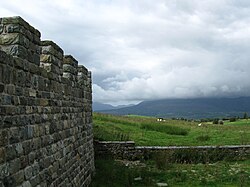
Inscribed stones, found at Harlech Castle and believed to be from Tomen y Mur, document the rebuilding of the fort in stone. Each stone commemorates, in paces, various lengths of completed fortress wall and the units (Centuria) who built them. Some of these Centurial Stones were on display at the now closed Segontium museum, Caernarfon. A section of the 2nd-century curtain wall has recently been reconstructed to give an impression of how the defences may once have looked.

Sub-Roman Wales

The site is important in Welsh mythology; it is the legendary palace of Ardudwy (Mur-y-Castell) in the fourth branch of the Mabinogi. Dominating the site today is a Norman era motte. Little is known about the fortification, but it is possible that it was constructed in 1095 by William Rufus in his attempt to conquer Wales.

Archaeological research

The fort's remains are extensive with many ancillary features being traceable as earthworks outside the fort: a parade ground, bath house, mansio (Inn), roads, burial mounds, a possible temple and a small military amphitheatre (Ludus) – a rare feature in Britain. [3] It has been speculated that the arena was built to compensate the legionaries for such a bleak posting, but it is also possible that the fort's very isolation allowed its preservation; many auxiliary forts having had their own arenas erased by ploughing, etc.

Related Research Articles

The Silures were a powerful and warlike tribe or tribal confederation of ancient Britain, occupying what is now south east Wales and perhaps some adjoining areas. They were bordered to the north by the Ordovices; to the east by the Dobunni; and to the west by the Demetae.

<span class="mw-page-title-main">Ordovices</span>

The Ordovīcēs were one of the Celtic tribes living in Great Britain before the Roman invasion. Their tribal lands were located in present-day North Wales and England, between the Silures to the south and the Deceangli to the north-east. Unlike the latter tribes that appear to have acquiesced to Roman rule with little resistance, the Ordovices fiercely resisted the Romans. They were eventually subjugated by the Roman governor Gnaeus Julius Agricola in the campaign of 77–78CE when the Romans overran their final strongholds on Anglesey.

<span class="mw-page-title-main">Dolwyddelan</span> Village in Wales

Dolwyddelan is a village and community in Conwy County Borough, Wales. The community occupies most of the valley of the Afon Lledr and comprises Dolwyddelan and Pentre Bont and the hamlets of Blaenau Dolwyddelan and Pont-y-Pant. It lies within Snowdonia, and the surrounding hills are part of the Moelwynion range. The population of the community was recorded as 454 in the 2021 census, and in the 2011 census the proportion of Welsh speakers was recorded as 50.8%.

<span class="mw-page-title-main">Trecastle</span> Village in Powys, Wales

Trecastle is a village in Powys, Wales, situated on the edge of the Brecon Beacons National Park (Welsh: Parc Cenedlaethol Bannau Brycheiniog) and in the community of Llywel. The village has a population of about 200.

<span class="mw-page-title-main">Pen-y-Gwryd</span>

Pen-y-Gwryd is a pass at the head of Nantygwryd and Nant Cynnyd rivers close to the foot of Snowdon in Gwynedd, Wales. The area is located at the junction of the A4086 from Capel Curig to Llanberis and Caernarfon and the A498 from Beddgelert and Nant Gwynant about a mile from the head of the Llanberis Pass. It is close to the boundary with Conwy county borough in northern Snowdonia. The famous mountaineering hostelry, Pen-y-Gwryd Hotel, is located in the pass. It is also a mountain rescue post with links to the other rescue posts at Ogwen Cottage and Plas y Brenin.

<span class="mw-page-title-main">Segontium</span> Roman fort in Gwynedd, Wales

Segontium is a Roman fort on the outskirts of Caernarfon in Gwynedd, North Wales.

<span class="mw-page-title-main">Llanfyllin</span> Human settlement in Wales

Llanfyllin is a market town and community in Powys, Wales. The town population in 2021 was 1,586 and the town's name means church or parish (llan) of St Myllin. The community includes the settlements of Bodfach, Ty Crwyn, Abernaint and several farms.

<span class="mw-page-title-main">Deva Victrix</span> Roman fort, Mid 70s AD

Deva Victrix, or simply Deva, was a legionary fortress and town in the Roman province of Britannia on the site of the modern city of Chester. The fortress was built by the Legio II Adiutrix in the 70s AD as the Roman army advanced north against the Brigantes, and rebuilt completely over the next few decades by the Legio XX Valeria Victrix. In the early 3rd century the fortress was again rebuilt. The legion probably remained at the fortress until the late 4th or early 5th century, upon which it fell into disuse.

Pen y Clawdd Castle is a ditched mound with a double moat, roughly circular in shape, with a diameter of approximately 28m to 30m and about 2.4m high. The castle is in Llanvihangel Crucorney, about five miles to the north of Abergavenny, Monmouthshire, in south east Wales and lies between the Usk and Monnow rivers. The mound was designated a scheduled monument in 1950 and described as a defensive medieval motte.

<span class="mw-page-title-main">Roman conquest of Anglesey</span> Two Roman invasions of Anglesey during the mid 1st century

The Roman conquest of Anglesey refers to two separate invasions of Anglesey in North West Wales that occurred during the early decades of the Roman conquest of Britain in the 1st century CE. The first invasion of North Wales began after the Romans had subjugated much of southern Britain. It was led by the Provincial governor of Britannia, Suetonius Paulinus, who led a successful assault on the island in 60–61 CE, but had to withdraw because of the Boudican revolt. In 77 CE, Gnaeus Julius Agricola's thorough subjugation of the island left it under Roman rule until the end of Roman rule in Britain in the early 5th century CE. The invasions occurred because Anglesey, which was recorded in Latin as Mona was a place of resistance to Roman rule because it was an important centre for the Celtic Druids and their religious practices.

<span class="mw-page-title-main">Llanddeiniolen</span> Community in Gwynedd, Wales

Llanddeiniolen is the name of a community area, in the county of Gwynedd, Wales, and is 124 miles (200 km) from Cardiff and 206 miles (332 km) from London. It comprises the hamlet also called Llanddeiniolen, and the villages of Deiniolen, Bethel, Dinorwig, Rhiwlas, Brynrefail and Penisarwaun. It is the third-largest community by population in Gwynedd, with 5072 people in the 2011 census. Also in the community is the dispersed settlement of Fachwen, located on the north shore of Llyn Padarn. The name derives from the Welsh saint Deiniol, first bishop of Bangor or from his son, saint Deiniolen.

References

Bibliography