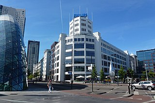
Eindhoven is a city and municipality in the Netherlands, located in the southern province of North Brabant of which it is its largest and is also located in the Dutch part of the natural region the Campine. With a population of 238,326 on 1 January 2022, it is the fifth-largest city of the Netherlands and the largest outside the Randstad conurbation.

The Meierij van 's-Hertogenbosch was one of the four parts of the Duchy of Brabant, the others being the Margraviate of Antwerp, the County of Brussels and the County of Leuven/Louvain. Located in the current-day Netherlands, it acquired its name from the bailiff of 's-Hertogenbosch, who administered the area in the name of the Dukes of Brabant. The Meierij roughly corresponds to the larger province of North Brabant.

Sint-Oedenrode is a town in the province of North Brabant.

Erpe-Mere is a municipality located in the Belgian province of East Flanders in the Denderstreek. The municipality comprises the towns of Aaigem, Bambrugge, Burst, Erondegem, Erpe, Mere, Ottergem and Vlekkem. There is also a hamlet in Bambrugge: Egem. Erpe-Mere is crossed by 2 brooks, the Molenbeek and the Molenbeek-Ter Erpenbeek. In 2022 Erpe-Mere had a total population of 20,127. The total area is 34.03 km². The current mayor of Erpe-Mere is Hugo De Waele, from the CD&V party.

Grimbergen is a municipality in the Belgian province of Flemish Brabant, 10 km north of the capital Brussels. It comprises the towns of Beigem, Grimbergen, Humbeek, and Strombeek-Bever. In 2017, it had a population of 37,030 and an area of 38.61 km2, giving a population density of 959 inhabitants per km2.

Zaventem is a Belgian municipality in the province of Flemish Brabant. It is located in the Dijleland area, one of the three large recreational areas which together form the Groene Gordel around the Brussels-Capital Region. The municipality comprises the subdivisions or deelgemeenten of Nossegem, Sint-Stevens-Woluwe, Sterrebeek and Zaventem proper. On 1 January 2006 Zaventem had a total population of 28,651. The total area is 27.62 square kilometres, which gives a population density of 1,037 inhabitants per km2. The official language is Dutch as it is within the Flemish Region. Zaventem is the home of Brussels Airport, together with neighbouring town of Diegem.

The Gender is a stream in the Dutch province of North Brabant. It originates in originally marshy flatlands near Steensel and flows through Veldhoven and its eastern district Meerveldhoven in a general east-northeast direction towards Eindhoven.

The Dommel is a small river in Belgium and the Netherlands, left tributary of the Dieze. It is 120 km long, of which 85 km in the Netherlands. The Dommel takes in water from the Keersop, Tongelreep, Run, Gender and Kleine Dommel streams and merges at 's-Hertogenbosch with the Aa stream to form the river Dieze, which subsequently flows towards the Meuse. The main cities and towns along the Dommel's course are Peer, Neerpelt, Valkenswaard, Dommelen, Eindhoven, Son en Breugel, Sint-Oedenrode, Boxtel, Sint-Michielsgestel and 's-Hertogenbosch.

The Campine or De Kempen is a natural region situated chiefly in north-eastern Belgium and parts of the south-eastern Netherlands which once consisted mainly of extensive moors, tracts of sandy heath, and wetlands. It encompasses a large northern and eastern portion of Antwerp Province and adjacent parts of Limburg in Belgium, as well as portions of the Dutch province of North Brabant and Dutch Limburg around Weert.

The Aa is a small river in the Netherlands. It rises near Nederweert in the southeastern province of Limburg, in the Peel region. It flows northwest through the province of North Brabant towards 's-Hertogenbosch, roughly along the Zuid-Willemsvaart canal. In 's-Hertogenbosch, at the confluence of the Aa and the Dommel, the river Dieze is formed, which flows into the Meuse a few km further. The main cities and towns along the Aa's course are Asten, Helmond, Veghel and 's-Hertogenbosch.

Binnendieze is the common name for the river and canal system within the city walls of 's-Hertogenbosch, the Netherlands. It is a tourist attraction. Near the north-west tip of the city walls, the confluence of the Binnendieze with the rivers Aa and Dommel forms the short river Dieze, tributary of the Meuse.

The River Wey is a main tributary of the River Thames in south east England. Its two branches, one of which rises near Alton in Hampshire and the other in West Sussex to the south of Haslemere, join at Tilford in Surrey. Once combined the flow is eastwards then northwards via Godalming and Guildford to meet the Thames at Weybridge. Downstream the river forms the backdrop to Newark Priory and Brooklands. The Wey and Godalming Navigations were built in the 17th and 18th centuries, to create a navigable route from Godalming to the Thames.

The Ise is a 43 km (27 mi) long, almost natural river of East Lower Saxony and Saxony-Anhalt, Germany. It crosses the district of Gifhorn from north to south and discharges into the Aller at Gifhorn itself.
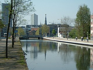
The Eindhovensch Kanaal is a canal in the Dutch province of North Brabant. It connects the center of Eindhoven with the Zuid-Willemsvaart. It was dug in the period 1843-1846, commissioned by the town of Eindhoven. The canal is 13.9 kilometers long and runs by a number of Eindhoven industrial areas and the towns of Geldrop, Mierlo and Helmond. The canal runs over the Kleine Dommel and the Goorloop, which are led under the canal by ducts.

Woluwe-Saint-Lambert or Sint-Lambrechts-Woluwe is one of the 19 municipalities of the Brussels-Capital Region, Belgium. In common with all of Brussels' municipalities, it is legally bilingual (French–Dutch). In French, it is often spelt Woluwé-Saint-Lambert to reflect the Frenchified pronunciation of what was originally a Dutch place name, but the official spelling is without an accent. The Woluwe stream, from which it takes its name, flows through the municipality.
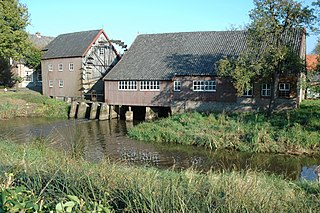
The Watermill at Opwetten is a watermill along the river Kleine Dommel, located on the Opwettenseweg 203 in Opwetten, Nuenen, Gerwen en Nederwetten, in the province of North Brabant, Netherlands. First mentioned in the 11th century, the watermill burned down and was rebuilt in 1764.
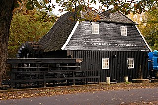
The Watermill at Gennep is a watermill along the river Dommel, located on the Genneperweg 143 in Gestel, Eindhoven, in the province of North Brabant, Netherlands. First mentioned in the 13th century, the watermill burned down and was rebuilt in 1587.

Sint-Michielsgestel is a village in the municipality of Sint-Michielsgestel, Netherlands.

The Kleine Dommel or Rul is a brook in the Campine and Meierij van 's-Hertogenbosch, Netherlands.

