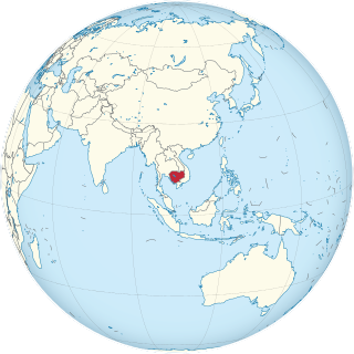
Cambodia is a country in mainland Southeast Asia. It borders Thailand, Laos, Vietnam, the Gulf of Thailand and covers a total area of approximately 181,035 km2 (69,898 sq mi). The country is situated in its entirety inside the tropical Indomalayan realm and the Indochina Time zone (ICT).

Tonlé Sap (; Khmer: ទន្លេសាប, Tônlé Sab ; lit. 'Fresh River' or commonly translated as 'Great Lake' is a lake in the northwest of Cambodia. Belonging to the Mekong River system, Tonlé Sap is the largest freshwater lake in Southeast Asia and one of the most diverse and productive ecosystems in the world. It has been designated as a Biosphere Reserve by UNESCO in 1997 due to its high biodiversity. In the 21st century, the lake and its surrounding ecosystems are under increasing pressure from deforestation, infrastructure development and climate change.

The Southeastern Indochina dry evergreen forests are a tropical dry broadleaf forest ecoregion of Indochina.
The Tonlé Sap Biosphere Reserve is a unique ecological phenomenon surrounding the Tonlé Sap or Great Lake of Cambodia. In 1997, it was successfully nominated as a UNESCO Biosphere Reserve.

The Guianan mangroves (NT1411) is a coastal ecoregion of southeastern Venezuela, Guyana, Suriname, French Guiana and Brazil. The mangroves provide an important habitat for migrating birds that winter in the area. Large areas are intact, although they are threatened by destruction of the trees for timber and to make way for agriculture, and from upstream agricultural and industrial pollution.

The Orinoco Delta swamp forests (NT0147) is an ecoregion of eastern Venezuela and northern Guyana covering the large and shifting Orinoco Delta. The vegetation is mostly permanently flooded rainforest. The ecoregion is relatively intact apart from a large area that was damaged by a failed flood control program in the 1960s. It is inaccessible, so logging is difficult, and the soil is unsuitable for farming. The main threat comes from oil exploration, which would bring an influx of settlers into the delta.

The Orinoco wetlands (NT0906) is an ecoregion of northeast Venezuela within the northern Orinoco Delta. It holds areas of tall grasses in flooded land, surrounded by mangroves and swamp forest, giving way to the drier Llanos savanna in the west.
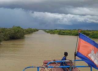
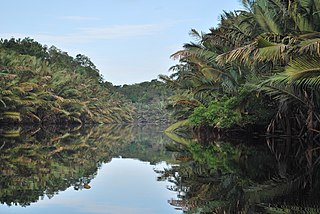
The Tonle Sap freshwater swamp forests ecoregion covers the seasonally flooded forests surrounding Tonlé Sap, the largest lake in Cambodia, and the floodplains of its connections to the Mekong River. Over 35% of the ecoregion experiences flooding during the wet season.

The Irrawaddy freshwater swamp forests ecoregion covers the freshwater portion of the delta of the Irrawaddy River, set back an average of 70 km from the Bay of Bengal by the saltwater mangroves. To the north is a rainforest belt with less inundated land. The region is extremely fertile due to the river-borne silt, but nearly-total conversion to agriculture has degraded the ecology. There are no fully protected areas in this ecoregion.
The Sumatran peat swamp forests ecoregion covers the low-lying peat swamp forests along the northeast coast of the island of Sumatra in Indonesia. As is typical for peat swamp forests, this ecoregion lies between a thin strip of saltwater-affected mangroves on the coast, and freshwater swamps and lowland rainforest forest on better drained soils further inland. Because the peat soil has relatively low nutrient levels, this ecoregion has been less used for agriculture, but burning and clearance has degraded half of the forest.

The Southwest Borneo freshwater swamp forests ecoregion covers a number disconnected patches of freshwater swamp forest along the southwestern coasts of Borneo. The swamps are generally set back a few kilometers or two from the sea by the saltwater-affected Sunda Shelf mangroves The relatively fertile, flat soil has led to much of this ecoregion being converted to agriculture.

The South Iran Nubo–Sindian desert and semi-desert ecoregion covers the northern coastal plain of the Persian Gulf and the inland desert hills south of the Zagros Mountains of Iran. The region also has extensions reaching into southeastern Iraq, and eastward into southwestern Pakistan. The region is one of hot sand deserts, shrubland, and open thorn woodlands inland. Mangrove forests and swamps are found along the coast.

The Mesoamerican Gulf-Caribbean mangroves ecoregion covers the series of disconnected mangrove habitats along the eastern coast of Central America. These salt-water wetlands are found in river deltas, lagoons, and low-lying areas facing the Gulf of Mexico and Caribbean Sea, from Tampico, Mexico to central Panama. The mangroves are areas of high biodiversity and endemism. Many of the sites are protected as national parks or nature reserves.

The Northern Dry Pacific Coast mangroves ecoregion covers the mangrove habitats in a series of sites along the Pacific Ocean coast of Guatemala and El Salvador. This part of Central America is relatively dry compared to higher elevations or more southerly areas, so the wetland mangroves serve as a refuge for animals of the interior during the winter dry season. The mangroves only extend a few kilometers inland to where the salt water influence is gone; the ecoregion surrounding the mangroves is the Central American dry forests ecoregion.

The Mayan Corridor mangroves ecoregion covers the mangrove habitats along the Caribbean Sea coast of the state of Quintana Roo in southern Mexico and a narrow strip on the north of Belize. The region is named for the Maya Civilization archeological sites along the coast. Biodiversity in the area high due to the interactions of different environments - coastal lagoons, river estuaries, coral reefs, and barrier beaches. The ecoregion supports Mexico's largest population of crocodiles.

The Petenes mangroves ecoregion covers mangrove habitat along the Gulf of Mexico coast of southern Mexico, where Campeche state and Yucatan state meet, centering on the Celestun Lagoon inland from the barrier-island town of Celestún. Because the region has relatively little rainfall and no rivers feeding the lagoons, the freshwater to support the mangrove ecosystem springs from underground aquifers. The area is important for migratory birds, and as a nesting area for sea turtles. The area around the Celestun Lagoon is protected by the Ría Celestún Biosphere Reserve, a UNESCO Biosphere Reserve, and Los Petenes Biosphere Reserve in Campeche.

The Tehuantepec-El Manchon mangroves ecoregion covers a series of mangrove woodlands along the Pacific Ocean coast of the state of Chiapas, Mexico. The ecoregion is relatively large and continuous, with trees up to 25 meters in height. The region supports stands of a type of yellow mangrove that normally only grown further south. The coast of Mexico here is wet - over 2,500 mm/year of rain. Four RAMSAR wetlands of international important are found in the zone, and a UNESCO Biosphere Reserve. Of particular importance are the wide variety of permanent and migratory birds in the area.

The Usumacinta mangroves ecoregion covers the mangrove forests ont the Gulf Coast of Mexico, around the margins of the Laguna de Términos. The "Ends" in the name refer to the mouths of the rivers that empty into the lagoon, including the Usumacinta River. This region, which is due south of the mouth of the Mississippi River across the Gulf of Mexico, receives an estimated one-third of the wintering birds migrating on the Mississippi Flyway. It is estimated that the lagoon supports 90 endangered species.

