
Parkville is an inner-city suburb in Melbourne, Victoria, Australia, 3 km (1.9 mi) north of Melbourne's Central Business District, located within the Cities of Melbourne and Merri-bek local government areas. Parkville recorded a population of 7,074 at the 2021 census.
The City of Stonnington is a local government area located within the metropolitan area of Melbourne, Australia. It comprises the inner south-eastern suburbs, between 3 and 13 km, from the Melbourne CBD. The city covers an area of 25.7 km2 (9.9 sq mi).

North Melbourne is an inner-city suburb in Melbourne, Victoria, Australia, 3 km (1.9 mi) north-west of Melbourne's Central Business District, located within the City of Melbourne local government area. North Melbourne recorded a population of 14,953 at the 2021 census.

Hawthorn East is a suburb of Melbourne, Victoria, Australia, 7 km (4.3 mi) east of the Melbourne central business district, located within the City of Boroondara local government area. Hawthorn East recorded a population of 14,834 at the 2021 census.
Clifton Hill is an inner-city suburb in Melbourne, Victoria, Australia, 4 km (2.5 mi) north-east of Melbourne's Central Business District, located within the City of Yarra local government area. Clifton Hill recorded a population of 6,606 at the 2021 census.
Armadale is an inner suburb in Melbourne, Victoria, Australia, 7 km south-east of Melbourne's Central Business District, located within the City of Stonnington local government area. Armadale recorded a population of 9,368 at the 2021 census.

South Yarra is an inner-city suburb in Melbourne, Victoria, Australia, 4 km south-east of Melbourne's Central Business District, located within the Cities of Melbourne and Stonnington local government areas. South Yarra recorded a population of 25,028 at the 2021 census.

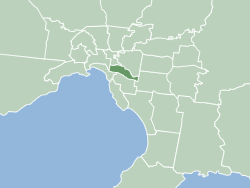
Toorak is a suburb of Melbourne, Victoria, Australia, 5 km (3.1 mi) south-east of Melbourne's Central Business District, located within the City of Stonnington local government area. Toorak recorded a population of 12,817 at the 2021 census.

Hawksburn railway station is a commuter railway station on the Frankston line, serving the south Melbourne suburb of South Yarra, Victoria, Australia. Hawksburn is an unstaffed status below ground structure station featuring four platforms, with an island platform and two side platforms all accessed by a pedestrian bridge. The station is listed on the Victorian Heritage Register, and was opened on 7 May 1879, with the stations’ namesake being the locality of Hawksburn, 600 metres from the station. The station is only partially accessible due to multiple steep access ramps.

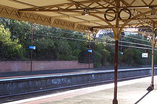
Toorak railway station is a commuter railway station on the northern boundary of Armadale, a suburb of Melbourne, Victoria, Australia. The station is listed on the Victorian Heritage Register, and was opened on 7 May 1879. The station is named after the nearby suburb of Toorak—located north of the station. The station consists of an island platform and two side platforms all accessed by a pedestrian bridge. There are two principal station buildings located on the central platform and on platform 4, consisting of a small two and one-story brick buildings. These buildings were provided in 1914, as ticketing and staff offices. The station is only partially accessible due to a multiple steep access ramps.

Royal Park railway station is located on the Upfield line in Victoria, Australia. It serves the northern Melbourne suburb of Parkville, and it opened on 9 September 1884.

The Division of Higgins is an Australian Electoral Division in Victoria for the Australian House of Representatives. The division covers 41 km2 (16 sq mi) in Melbourne's inner south-eastern suburbs. The main suburbs include Armadale, Ashburton, Carnegie, Glen Iris, Kooyong, Malvern, Malvern East, Murrumbeena, Prahran and Toorak; along with parts of Camberwell, Ormond and South Yarra. Though historically a safe conservative seat, Higgins was won by the Liberal Party by a margin of just 3.9 percent over the Labor Party at the 2019 election, the closest result in the seat’s history. It then flipped to Labor in the 2022 election.

The Monash Freeway is a major urban freeway in Victoria, Australia, linking Melbourne's CBD to its south-eastern suburbs and beyond to the Gippsland region. It carries up to 180,000 vehicles per day and is one of Australia's busiest freeways. The entire stretch of the Monash Freeway bears the designation M1.

Chapel Street is a street in Melbourne, Victoria, running along the inner suburbs of South Yarra, Prahran, Windsor, St Kilda and St Kilda East.

West Melbourne is an inner-city suburb in Melbourne, Victoria, Australia, 2 km (1.2 mi) north-west of the Melbourne central business district, located within the City of Melbourne local government area. West Melbourne recorded a population of 8,025 at the 2021 census.
The Division of Fawkner was an Australian Electoral Division in Victoria. The division was created in 1906 as a replacement for Southern Melbourne, and was abolished itself in 1969. It was named for John Pascoe Fawkner, one of the founders of Melbourne. It was located in the inner southern suburbs of Melbourne, including at various times Prahran, South Yarra, St Kilda and Toorak. It was usually a safe conservative seat, but was occasionally won by the Australian Labor Party.

Tourism is a significant industry in the state of Victoria, Australia. The country's second most-populous city, Melbourne was visited by 2.7 million international overnight visitors and 9.3 million domestic overnight visitors during the year ending December 2017.

Toorak Gardens is a leafy, mainly residential inner eastern suburb of Adelaide, South Australia, located 2 km east of the Adelaide city centre.
Burwood Highway is a major transportation link with Melbourne's eastern suburbs. It begins in the suburb of Kooyong, Melbourne at the junction of the Monash Freeway as Toorak Road between Monash Freeway and Warrigal Road, and finishes in Belgrave, Victoria in the Dandenong Ranges. The highway is considered a major link for people who live in the Dandenong Ranges and acts as one of the major feeder roadway in the area along with Canterbury Road, Ferntree Gully Road, EastLink and Wellington Road.
The electoral district of Toorak was an electorate of the Victorian Legislative Assembly in the British colony and later Australian state of Victoria.