
The United Nations Convention on the Law of the Sea (UNCLOS), also called the Law of the Sea Convention or the Law of the Sea Treaty, is an international agreement that establishes a legal framework for all marine and maritime activities. As of June 2016, 167 countries and the European Union are parties.

The Torres Strait, also known as Zenadh Kes, is a strait between Australia and the Melanesian island of New Guinea. It is 150 km (93 mi) wide at its narrowest extent. To the south is Cape York Peninsula, the northernmost extremity of the Australian mainland. To the north is the Western Province of Papua New Guinea. It is named after the Spanish navigator Luís Vaz de Torres, who sailed through the strait in 1606.

Territorial waters are informally an area of water where a sovereign state has jurisdiction, including internal waters, the territorial sea, the contiguous zone, the exclusive economic zone, and potentially the extended continental shelf. In a narrower sense, the term is often used as a synonym for the territorial sea.
The Torres Strait Islands are a group of at least 274 small islands in the Torres Strait, a waterway separating far northern continental Australia's Cape York Peninsula and the island of New Guinea. They span an area of 48,000 km2 (19,000 sq mi), but their total land area is 566 km2 (219 sq mi).

The Bismarck Sea lies in the southwestern Pacific Ocean within the nation of Papua New Guinea. It is located northeast of the island of New Guinea and south of the Bismarck Archipelago. It has coastlines in districts of the Islands Region, Momase Region, and Papua Region.

Boigu Island is the most northerly inhabited island of Queensland and of Australia. It is part of the Top Western group of the Torres Strait Islands, which lie in the Torres Strait separating Cape York Peninsula from the island of New Guinea. The mainland of Papua New Guinea is only 6 kilometres (3.7 mi) away from Boigu. Boigu has an area of 89.6 square kilometres (34.6 sq mi). Boigu Island is the name of the locality on the island within the Torres Strait Island Region. Boigu is predominantly inhabited by indigenous Torres Strait Islanders. In the 2021 census, the population of the island was 199, of whom 189 people or 95% of the population identified as Indigenous Australians.
Saibai Island, commonly called Saibai, is an island of the Torres Strait Islands archipelago, located in the Torres Strait of Queensland, Australia. The island is situated north of the Australian mainland and south of the island of New Guinea. The island is a locality within the Torres Strait Island Region local government area. The town of Saibai is located on the north-west coast of the island. According to the 2016 census, Saibai Island had a population of 465 people.

Moa Island, also called Banks Island, is an island of the Torres Strait Islands archipelago that is located 40 kilometres (25 mi) north of Thursday Island in the Banks Channel of Torres Strait, Queensland, Australia. It is also a locality within the Torres Strait Island Region local government area. This island is the largest within the "Near Western" group. It has two towns, Kubin on the south-west coast and St Pauls on the east coast, which are connected by bitumen and a gravel road. In the 2016 census, Moa Island had a population of 448 people.

Coconut Island, Poruma Island, or Puruma in the local language, is an island in the Great North East Channel near Cumberland Passage, Torres Strait, Queensland, Australia. One of the Torres Strait Islands, Coconut Island is 130 kilometres (81 mi) northeast of Thursday Island. Administratively, Coconut Island is a town and Poruma Island is the locality within the Shire of Torres.
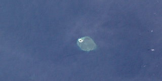
Warul Kawa Indigenous Protected Area is a small island that is part of Australia's National Reserve System, located 34 kilometres (21 mi) south of Papua New Guinea and about 200 kilometres (120 mi) north of Thursday Island, Torres Strait. The protected area and island are the most north westerly of the Torres Strait Islands located in the water of Torres Strait, part of Queensland in Australia, and 74 kilometres (46 mi) from Indonesia, at the border of Papua province.

Talbot Islands are a group of Torres Strait Islands in Queensland, Australia. They lie between the Australian mainland and the island of New Guinea and a few kilometres west of Saibai Island, Torres Strait, only 4 km from the Papua New Guinea mainland at the mouth of the Mai Kussa River.

Stephen Island, called Ugar in the local Meriam language, lies in the eastern group of the Torres Strait Islands archipelago of Queensland, Australia. The island is within the locality of Ugar Island within the local government area of the Torres Strait Island Region.

The Australia–Indonesia border is a maritime boundary running west from the two countries' tripoint maritime boundary with Papua New Guinea in the western entrance to the Torres Straits, through the Arafura Sea and Timor Sea, and terminating in the Indian Ocean. The boundary is, however, broken by the Timor Gap, where Australian and East Timorese territorial waters meet and where the two countries have overlapping claims to the seabed.
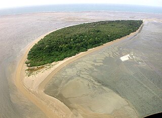
Bramble Cay, also known as Maizab Kaur and Massaramcoer, is a small cay located at the northeastern edge of Australia and the Torres Strait Islands of Queensland and at the northern end of the Great Barrier Reef. Lying around 50 km (31 mi) north of Erub Island in the Gulf of Papua, it is the northernmost point of land of Australia and marks the end of the Great Barrier Reef.
The Papua New Guinea – Solomon Islands Maritime Boundary Treaty is a 1989 treaty in which Papua New Guinea and the Solomon Islands agreed to delimit a maritime boundary between the two states.

Dauan Island is an island in the Torres Strait, Queensland, Australia; it is also known as Cornwallis Island. Dauan Island is also a town and locality in the Torres Strait Island Region, Queensland, Australia.

Australia's exclusive economic zone (EEZ) was declared on 1 August 1994 and extends from 12 to 200 nautical miles from the coastline of Australia and its external territories, except where a maritime delimitation agreement exists with another state. To the 12 nautical-mile boundary is Australia's territorial waters. Australia has the third-largest exclusive economic zone, behind France and the United States but ahead of Russia, with the total area of 8,148,250 square kilometres (3,146,060 sq mi), which exceeds its land territory.

Masig Island is an island and locality in the Torres Strait Island Region, Queensland, Australia. In the 2016 census Masig Island had a population of 270 people.
The borders of Indonesia include land and maritime borders with Malaysia, Papua New Guinea, and East Timor, as well as shared maritime boundaries with Australia, India, Palau, Philippines, Singapore, Thailand, and Vietnam.

The Indonesia–Papua New Guinea border is the international border between Indonesia and Papua New Guinea. The border, which divides the island of New Guinea in half, consists of two straight north–south lines connected by a short section running along the Fly river, totalling 824 km (512 mi). The boundary separates Papua, Highland Papua, and South Papua provinces of Indonesia from Sandaun and Western provinces of Papua New Guinea.