Torrid zone

Last updated
The Terrestrial Sphere of Crates of Mallus (c. 150 BCE), showing land masses in both the northern and southern hemispheres of the western hemisphere Crates Terrestrial Sphere.png
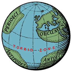
The Terrestrial Sphere of Crates of Mallus (c.150 BCE), showing land masses in both the northern and southern hemispheres of the western hemisphere
Modern world map with the intertropical zone highlighted in crimson World map indicating tropics and subtropics.png
Modern world map with the intertropical zone highlighted in crimson

The torrid zone was the name given by ancient Greek and Roman geographers to the equatorial area of the Earth, so hot that it was impenetrable. That notion became a deterrent for European explorers until the 15th century.

Contents

Origin

Aristotle posited that the western half of the temperate zone on the other side of the world from Greece might be habitable and that, because of symmetry, there must be in the Southern Hemisphere a temperate zone corresponding to that in the northern. He thought, however, that the excessive heat in the torrid zone would prevent the exploration. [1]

Strabo referred to:

the meridian through Syene is drawn approximately along the course of the Nile from Meroë to Alexandria, and this distance is about ten thousand stadia; and Syene must lie in the centre of that distance; so that the distance from Syene to Meroë is five thousand stadia. And when you have proceeded about three thousand stadia in a straight line south of Meroë, the country is no longer inhabitable on account of the heat, and therefore the parallel though these regions, being the same as that through the Cinnamon-producing Country, must be put down as the limit and the beginning of our inhabited world on the South. [2]

In 8 AD the poet Ovid wrote in his Metamorphoses .

...the celestial vault is cut by two zones on the right and two on the left, and there is a fifth zone between, hotter than these, so did the providence of God mark off the enclosed mass with the same number of zones, and the same tracts were stamped upon the earth. The central zone of these may not be dwelt in by reason of the heat [3]

Pomponius Mela, the first Roman geographer, asserted that the Earth had two habitable zones, a north and a south one. The second population were known as Antichthones. However, it would be impossible to get into contact with each other because of the unbearable heat at the equator (De orbis situ 1.4).

Proved wrong

Many Europeans had assumed that Cape Bojador, in Western Sahara, marked the beginning of the impenetrable torrid zone until 1434, when the Portuguese sailed past the cape and reported that no torrid zone existed. [4]

Related Research Articles

<span class="mw-page-title-main">Pytheas</span> Ancient Greek geographer (born ca. 350 BC)

Pytheas of Massalia was a Greek geographer, explorer and astronomer from the Greek colony of Massalia. He made a voyage of exploration to northwestern Europe in about 325 BC, but his account of it, known widely in antiquity, has not survived and is now known only through the writings of others.

<span class="mw-page-title-main">Eratosthenes</span> Greek mathematician, geographer, poet (c. 276 – c. 195/194 BC)

Eratosthenes of Cyrene was a Greek polymath: a mathematician, geographer, poet, astronomer, and music theorist. He was a man of learning, becoming the chief librarian at the Library of Alexandria. His work is comparable to what is now known as the study of geography, and he introduced some of the terminology still used today.

<span class="mw-page-title-main">Strabo</span> Greek geographer, philosopher and historian (64/63 BC–c.24 AD)

Strabo was a Greek geographer, philosopher, and historian who lived in Asia Minor during the transitional period of the Roman Republic into the Roman Empire.

<span class="mw-page-title-main">Tropics</span> Region of Earth surrounding the Equator

The tropics are the regions of Earth surrounding the Equator. They are defined in latitude by the Tropic of Cancer in the Northern Hemisphere at 23°26′10.0″ (or 23.43611°) N and the Tropic of Capricorn in the Southern Hemisphere at 23°26′10.0″ (or 23.43611°) S. The tropics are also referred to as the tropical zone and the torrid zone.

<span class="mw-page-title-main">Lichas</span>

In Greek mythology, Lichas was Heracles' servant, who brought the poisoned shirt from Deianira to Hercules because of Deianira's jealousy of Iole, which killed him.

<span class="mw-page-title-main">History of geodesy</span>

The history of geodesy (/dʒiːˈɒdɪsi/) began during antiquity and ultimately blossomed during the Age of Enlightenment.

<span class="mw-page-title-main">Pomponius Mela</span> 1st century AD Roman geographer

Pomponius Mela, who wrote around AD 43, was the earliest known Roman geographer. He was born in Tingentera and died c. AD 45.

<span class="mw-page-title-main">Crates of Mallus</span> Ancient Greek philosopher

Crates of Mallus was a Greek grammarian and Stoic philosopher, leader of the literary school and head of the library of Pergamum. He was described as the Crates from Mallus to distinguish him from other philosophers by the same name. His chief work was a critical and exegetical commentary on Homer. He is also famous for constructing the earliest known globe of the Earth.

The river Eridanos or Eridanus is a river in Northern Europe mentioned in Greek mythology and historiography.

Apollodorus of Artemita was a Greek historian who flourished between 130 and 87 BC. He hailed from the Greco-Parthian city of Artemita in Apolloniatis and was a citizen of the Parthian Empire.

<span class="mw-page-title-main">Cataracts of the Nile</span> Series of six whitewater rapids

The Cataracts of the Nile are shallow lengths of the Nile river, between Khartoum and Aswan, where the surface of the water is broken by many small boulders and stones jutting out of the river bed, as well as many rocky islets. In some places, these stretches are punctuated by whitewater, while at others the water flow is smoother but still shallow.

Deimachus or Daimachus was a Greek from Plataeae, who lived during the third-century BCE. He became an ambassador to the court of the Mauryan ruler Bindusara "Amitragatha" in Pataliputra in India. Deimachus was sent by Antiochus I Soter.

<span class="mw-page-title-main">Serica</span> One of the easternmost countries of Asia known to the ancient Greeks and Romans

Serica was one of the easternmost countries of Asia known to the Ancient Greek and Roman geographers. It is generally taken as referring to North China during its Zhou, Qin, and Han dynasties, as it was reached via the overland Silk Road in contrast to the Sinae, who were reached via the maritime routes. A similar distinction was later observed during the Middle Ages between "Cathay" (north) and "Mangi" or "China" (south). The people of Serica were the Seres, whose name was also used for their region. Access to Serica was eased following the Han conquest of the Tarim Basin but largely blocked when the Parthian Empire fell to the Sassanids. Henry Yule summarized the classical geographers:

If we fuse into one the ancient notices of the Seres and their country, omitting anomalous statements and manifest fables, the result will be something like the following:—"The region of the Seres is a vast and populous country, touching on the east the Ocean and the limits of the habitable world, and extending west to Imaus and the confines of Bactria. The people are civilized, mild, just, and frugal, eschewing collisions with their neighbours, and even shy of close intercourse, but not averse to dispose of their own products, of which raw silk is the staple, but which include also silk-stuffs, fine furs, and iron of remarkable quality." That is manifestly a definition of the Chinese.

<span class="mw-page-title-main">Amanirenas</span> Queen regnant of Kush

Amanirenas, was queen regnant of the Kingdom of Kush from the end of the 1st century BCE to beginning of the 1st century CE. She is known for a failed uprising against the Roman Empire.

<span class="mw-page-title-main">Geographical zone</span> Major regions of Earths surface demarcated by latitude

The five main latitude regions of Earth's surface comprise geographical zones, divided by the major circles of latitude. The differences between them relate to climate. They are as follows:

  1. The North Frigid Zone, between the North Pole at 90° N and the Arctic Circle at 66°33′50.0″ N, covers 4.12% of Earth's surface.
  2. The North Temperate Zone, between the Arctic Circle at 66°33′50.0″ N and the Tropic of Cancer at 23°26′10.0″ N, covers 25.99% of Earth's surface.
  3. The Torrid Zone, between the Tropic of Cancer at 23°26′10.0″ N and the Tropic of Capricorn at 23°26′10.0″ S, covers 39.78% of Earth's surface.
  4. The South Temperate Zone, between the Tropic of Capricorn at 23°26′10.0″ S and the Antarctic Circle at 66°33′50.0″ S, covers 25.99% of Earth's surface.
  5. The South Frigid Zone, from the Antarctic Circle at 66°33′50.0″ S and the South Pole at 90° S, covers 4.12% of Earth's surface.
<span class="mw-page-title-main">Macrobians</span> Legendary people

The Macrobians (Μακροβίοι) were a legendary people and kingdom positioned in the Horn of Africa mentioned by Herodotus. It is one of the peoples postulated by the Greeks to exist at the extremity of the known world, in this case in the extreme south, contrasting with the Hyperboreans in the extreme north.

<span class="mw-page-title-main">Regio Patalis</span> Region in antiquity around the Indus River Delta

Regio Patalis is Latin for “the region of Patala”, that is the region around the ancient city of Patala at the mouth of the Indus River in Sindh, Pakistan. The historians of Alexander the Great state that the Indus parted into two branches at the city of Patala before reaching the sea, and the island thus formed was called Patalene, the district of Patala. Alexander constructed a harbour at Patala.

Kolonai was an ancient Greek city in the south-west of the Troad region of Anatolia. It has been located on a hill by the coast known as Beşiktepe, about equidistant between Larisa to the south and Alexandreia Troas to the north. It is 3.3 km east of the modern village of Alemşah in the Ezine district of Çanakkale Province, Turkey. Its name in Ancient Greek is the plural form of κολώνη (kolōnē), 'hill, mound', a common name for promontories with hills on them in the Eastern Mediterranean. It is not to be confused with Lampsacene Kolonai, a settlement situated in the hills above Lampsacus in the north-east of the Troad.

<span class="mw-page-title-main">Earth's circumference</span> Distance around the Earth

Earth's circumference is the distance around Earth. Measured around the equator, it is 40,075.017 km (24,901.461 mi). Measured passing through the poles, the circumference is 40,007.863 km (24,859.734 mi).

Bybassus or Bybassos or Bubassus or Bubassos was a town in ancient Caria. Ephorus, according to Stephanus of Byzantium, wrote Bybasstum or Bybasston (Βύβασστον) and Bybastium or Bybastion (Βυβάστιον); and Diodorus means the same place, when he calls it Bubastus of the Chersonesus. Pliny the Elder has a "regio Bubassus;" and he adds, "there was a town Acanthus, otherwise called Dulopolis." He places the "regio Bubassus" next to Triopia, the district of Triopium. Finally, Pomponius Mela mentions a Bubassius Sinus. The Bubassia Chersonesus is mentioned by Herodotus. Herodotus tells a story of the Cnidians attempting to cut a canal through a narrow neck of land for the purpose of insulating their peninsula, and protecting themselves against the Persians; they were at the work while Harpagus was conquering Ionia. The isthmus where they made the attempt was five stadia wide, and rocky. This place cannot be the isthmus which connects the mainland with the high peninsula, once called Cape Krio (now Cape Deveboynu, for it is sandy, and Strabo says that Cape Krio was once an island, but in his time was connected with the land by a causeway. Besides this, the chief part of the city of Cnidus was on the mainland; though we cannot be sure that this was so in the time of Harpagus. The passage in Herodotus is somewhat obscure, but mainly because it is ill pointed. His description is in his usually diffuse, hardly grammatical, form. Herodotus says, "Both other Hellenes inhabit this country and Lacedaemonian colonists, Cnidians, their territory being turned to the sea, and commencing from the Chersonesus Bubassiae, and all the Cnidia being surrounded by the sea, except a small part (for on the north it is bounded by the Gulf Ceramicus, and on the south by the sea in the direction of Syme and Rhodus; now at this small part, being about five stadia, the Cnidians were working to dig a canal." It is clear, then, that he means a narrow neck some distance east of the town of Cnidus.

References

  1. Sanderson, Marie (April 1999). "The Classification of Climates from Pythagoras to Koeppen". Bulletin of the American Meteorological Society. 80 (4): 669–673. JSTOR   26214921.
  2. Strabo. GEOGRAPHY. Book II Chapter 5. Retrieved 31 August 2023.{{cite book}}: CS1 maint: location (link)
  3. Ovid. Metamorphoses, Book I.
  4. Hansen, Valerie; Curtis, Kenneth R. (2015). Voyages in World History, Brief. Cengage Learning. p. 335. ISBN   9781305537705 . Retrieved 28 March 2023.