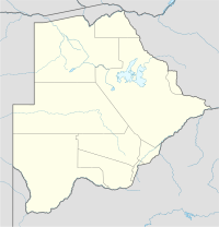
Botswana, officially the Republic of Botswana, is a landlocked country in Southern Africa. Botswana is topographically flat, with approximately 70 percent of its territory being the Kalahari Desert. It is bordered by South Africa to the south and southeast, Namibia to the west and north, Zambia to the north and Zimbabwe to the northeast. Being a country of slightly over 2.4 million people, and roughly the size of France, Botswana is one of the most sparsely populated countries in the world. It is essentially the nation state of the Tswana people, who make up 79% of the population.

The economy of Botswana is currently one of the world's fastest growing economies, averaging about 5% per annum over the past decade. Growth in private sector employment averaged about 10% per annum during the first 30 years of the country's independence. After a period of stagnation at the turn of the 21st century, Botswana's economy registered strong levels of growth, with GDP growth exceeding 6–7% targets. Botswana has been praised by the African Development Bank for sustaining one of the world's longest economic booms. Economic growth since the late 1960s has been on par with some of Asia's largest economies. The government has consistently maintained budget surpluses and has extensive foreign-exchange reserves.

The Kalahari Desert is a large semi-arid sandy savanna in Southern Africa extending for 900,000 square kilometres (350,000 sq mi), covering much of Botswana, as well as parts of Namibia and South Africa.

The San peoples, or Bushmen, are the members of any of the indigenous hunter-gatherer cultures of southern Africa, and the oldest surviving cultures of the region. Their recent ancestral territories span Botswana, Namibia, Angola, Zambia, Zimbabwe, Lesotho, and South Africa.

Maun is the fifth-largest town in Botswana. As of 2011, it had a population of 55,784. Maun is the "tourism capital" of Botswana and the administrative centre of Ngamiland district. Francistown and Maun are linked by the A3 highway. Maun is also the headquarters of numerous safari and air-charter operations who run trips into the Okavango Delta.

Kuruman is a small town in the Northern Cape province of South Africa. It is known for its scenery and the Eye of Kuruman, a geological feature that brings water from deep underground. The abundance of water produces an unexpected swathe of green amidst the barren plains and is known as the "Oasis of the Kalahari". It was at first a mission station of the London Missionary Society founded by Robert Moffat in 1821. It was also the place where David Livingstone arrived for his first position as a missionary in 1841. The Kuruman River, which is dry except for flash floods after heavy rain, is named after the town.

Francistown is the second-largest city in Botswana, with a population of about 103,417 and 147,122 inhabitants for its agglomeration at the 2022 census. It is located in eastern Botswana, about 400 kilometres (250 mi) north-northeast from the capital, Gaborone. Francistown is located at the confluence of the Tati and Ntshe rivers, and near the Shashe River and 90 kilometres (56 mi) from the international border with Zimbabwe.
Debswana Diamond Company Limited, or simply Debswana, is a mining company located in Botswana, and is the world's leading producer of diamonds by value. Debswana operates four diamond mines in the eastern and central parts of Botswana, as well as a coal mine. Debswana is a joint venture between the government of Botswana and the South African diamond company De Beers; each party owns 50 percent of the company.

The Boteti River is a natural watercourse in Botswana. It derives flow from the core Okavango Delta through the Thamalakane River in Maun.

Ghanzi is a town in the middle of the Kalahari Desert the western part of the Republic of Botswana in southern Africa. The region is the country's pride in contributing a large portion towards the beef industry. In fact, Ghanzi farmers provide about 75% percent of beef exports, according to the Botswana Meat Commission, primarily to the United Kingdom and the European Union.

The North-West District or Ngamiland is one of the first-level administrative subdivisions of Botswana. For census and administrative purposes Ngamiland is subdivided into Ngamiland East, Ngamiland West and Ngamiland Delta (Okavango). It is governed by a District Commissioner, appointed by the national government, and the elected North-West District Council. The administrative centre is Maun.

Gumare or Gomare is a rural village located in the North-West District of Botswana, near the Okavango Delta. The population of Gumare was 6,067 in 2001 census, but had risen to 8,532 iby the 2011 census.
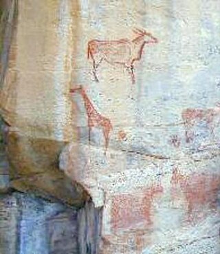
The Tsodilo Hills are a UNESCO World Heritage Site (WHS), consisting of rock art, rock shelters, depressions, and caves in Botswana, Southern Africa. It gained its WHS listing in 2001 because of its unique religious and spiritual significance to local peoples, as well as its unique record of human settlement over many millennia. UNESCO estimates there are over 4500 rock paintings at the site. The site consists of a few main hills known as the Child Hill, Female Hill, and Male Hill.
Nokaneng is a village in North-West District, Botswana. It is located close to the Okavango Delta, and is served by Nokaneng Airport. The population of Nokaneng was 1,590 in 2001 census.

The mining industry of Botswana has dominated the national economy of Botswana since the 1970s, being a primary sector industry. Diamond has been the leading component of the mineral sector ever since production of gems started being extracted by the mining company Debswana. Most of Botswana's diamond production is of gem quality, resulting in the country's position as the world's leading producer of diamond by value. Copper, gold, nickel, coal and soda ash production also has held significant, though smaller, roles in the economy.
The Sua Pan or Sowa Pan is a large natural topographic depression within the Makgadikgadi region of Botswana. It is located near the village of Sowa, whose name means salt in the language of the San. The Sua salt pan is one of three large pans within the Makgadikgadi, the other two being Nxai Pan and Nwetwe Pan.
Copper metallurgy in Africa encompasses the study of copper production across the continent and an understanding of how it influenced aspects of African archaeology.
Ancestral land conflict over the Central Kalahari Game Reserve (CKGR) arose in the 1970s between the government of Botswana and the San people (Bushmen), and is ongoing, resulting in one of the most expensive court cases in the history of Botswana.
Ngamiland East is one of the subdistricts of Ngamiland District of Botswana.

The geology of Namibia encompasses rocks of Paleoproterozoic, Mesoproterozoic and Neoproterozoic and Paleozoic to Cenozoic age. About 46% of the countryʼs surface are bedrock exposure, while the remainder is covered by the young overburden sediments of the Kalahari and Namib deserts.