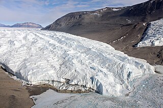
The Taylor Glacier is a glacier in Antarctica about 35 nautical miles long, flowing from the plateau of Victoria Land into the western end of Taylor Valley, north of the Kukri Hills. It flows to the south of the Asgard Range. The middle part of the glacier is bounded on the north by the Inland Forts and on the south by Beacon Valley.
Pedro Bank is a large bank of sand and coral, partially covered with seagrass, about 80 km south and southwest of Jamaica, rising steeply from a seabed of 800 metres depth. It slopes gently from the Pedro Cays to the west and north with depths from 13 to 30 metres. The total area of the bank within the 100-metre (328-foot) isobath measures 8,040 square kilometres. The area of a depth to 40 metres is triangular, 70 kilometres long east-west, and 43 kilometres wide. 2,400 square kilometres are less than 20 metres deep. With its islets, cays and rocks, a total land area of 270,000 m2 (2,906,256 sq ft), it is the location of one of the two offshore island groups of Jamaica, the other one being the Morant Cays. The bank is centered at 17°06′N78°20′W.

Sklené is a village and municipality in Turčianske Teplice District in the Žilina Region of northern central Slovakia.
Pesega is a village on the island of Upolu in Samoa. It is located on western outskirts of Apia, the country's capita. Pesega is part of Faleata West Electoral Constituency which forms part of the larger political district of Tuamasaga.

Cabañes de Esgueva is a municipality located in the province of Burgos, Castile and León, Spain. According to the 2004 census (INE), the municipality has a population of 243 inhabitants.

San Martín de la Virgen de Moncayo is a municipality located in the province of Zaragoza, Aragon, Spain. According to the 2004 census (INE), the municipality has a population of 291 inhabitants.
The electoral district of Sunshine was an electoral district of the Legislative Assembly in the Australian state of Victoria.

Birzhan sal District is a district of Akmola Region in northern Kazakhstan. The administrative center of the district is the town of Stepnyak. In 2017, Enbekshilder District was renamed Birzhan sal District. Population: 17,930 ; 25,599.
Jitpur is a town and Village Development Committee in Ilam District in the Province No. 1 of eastern Nepal. At the time of the 1991 Nepal census it had a population of 5,454 persons residing in 989 individual households.
Tatoba is a village in the municipality of Osakücə in the Lankaran Rayon of Azerbaijan.

The Gulf of Salwah is the southern portion of the Gulf of Bahrain. The Gulf of Salwah is a narrow bay separating the peninsula of Qatar from Saudi Arabia. It is bordered to the west by a well-vegetated shoreland containing palm trees and reed beds. To the east are low cliffs and hills, with sand dunes and salt flats at the southern end.
Municipality of Escuinapa is a municipality in the Mexican state of Sinaloa in northwestern Mexico. The seat is Escuinapa de Hidalgo.
Esen, Bulgaria is a village in Sungurlare Municipality, in Burgas Province, in southeastern Bulgaria.
Vivaldi Glacier is a glacier lying between the Colbert Mountains and the Lully Foothills, flowing south from Purcell Snowfield into the head of Schubert Inlet on the west coast of Alexander Island, Antarctica. The feature appears to be first shown on maps of the United States Antarctic Service (USAS) which photographed Alexander Island from the air in 1940. It was mapped from air photos obtained by the Ronne Antarctic Research Expedition in 1947–48, by Searle of the Falkland Islands Dependencies Survey in 1960. Named "Vivaldi Gap" by the United Kingdom Antarctic Place-Names Committee in 1961, after Antonio Vivaldi (1678–1741), Venetian composer. The name was amended to Vivaldi Glacier following review of Landsat program imagery, 1979, displaying flow lines in the feature.
Sandhø Heights is a bare rock heights forming the summit area in the central Conrad Mountains, in Queen Maud Land. Discovered and photographed by the German Antarctic Expedition of 1938-39 and mapped by Norway from air photos and surveys by Norwegian Antarctic Expedition, 1956–60, and named Sandhø.
German submarine U-58 was a Type IIC U-boat of Nazi Germany's Kriegsmarine that served in the Second World War. She was produced by Deutsche Werke AG, Kiel. Ordered on 17 June 1937, she was laid down on 29 September as yard number 257. She was launched on 12 October 1938 and commissioned on 4 February 1939 under the command of Oberleutnant zur See Herbert Kuppisch.
Sibnica is a village situated in Kraljevo municipality in Serbia.
In the 18th and 19th centuries, Karamania was an exonym used by Europeans for the southern (Mediterranean) coast of Anatolia, then part of the Ottoman Empire. It can also refer to the general south central Anatolian region, whose name is reflected on the modern town of Karaman. It is also the namesake of the larger Karaman Province of Turkey, the historical Karaman Eyalet of the Ottoman Empire, the medieval Turkish Karamanids dynasty and state from the region, and the Karamanlides, a Turkish-speaking Orthodox Christian group originally from the area.
Kemps Creek is a creek located in Sydney, Australia. It is a tributary of South Creek which flows into the Hawkesbury River. The source of the creek is about 2 km east by north of Catherine Field and flows in a roughly northerly direction through the suburbs of Austral and Kemps Creek.
