
Located in Oceania, Tonga is a small archipelago in the South Pacific Ocean, directly south of Samoa and about two-thirds of the way from Hawaii to New Zealand. It has 169 islands, 36 of them inhabited, which are in three main groups – Vavaʻu, Haʻapai, and Tongatapu – and cover an 800-kilometre (500-mile)-long north–south line. The total size is just 747 km2 (288 sq mi). Due to the spread out islands it has the 40th largest Exclusive Economic Zone of 659,558 km2 (254,657 sq mi).

George Tupou I, originally known as Tāufaʻāhau I, was the first king of modern Tonga. He adopted the name Siaosi, the Tongan equivalent of George, after King George III of the United Kingdom, when he was baptized in 1831. His nickname was Lopa-ukamea, meaning iron cable.
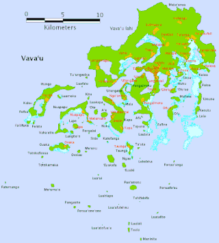
Vavaʻu is an island group, consisting of one large island and 40 smaller ones, in Tonga. It is part of Vavaʻu District, which includes several other individual islands. According to tradition, the Maui god created both Tongatapu and Vavaʻu, but put a little more effort into the former. Vavaʻu rises 204 m (669 ft) above sea level at Mount Talau. The capital is Neiafu, situated at the Port of Refuge.

Haʻapai is a group of islands, islets, reefs, and shoals in the central part of Tonga. It has a combined land area of 109.30 square kilometres (42.20 sq mi). The Tongatapu island group lies to its south, and the Vavaʻu group lies to its north. Seventeen of the Haʻapai islands are inhabited. Their combined population is 5,419. The highest point in the Ha‘apai group, and in all of Tonga, is on Kao, which rises almost 1,050 metres (3,440 ft) above sea level.

ʻEua is an island in the kingdom of Tonga. It is close to Tongatapu, but forms a separate administrative division. It has an area of 87.44 km2 (33.76 sq mi), and a population in 2021 of 4,903 people.

Fonualei is an uninhabited volcanic island in the kingdom of Tonga. It 70 km northwest of Vavaʻu and is part of the highly active Kermadec-Tonga subduction zone and its associated volcanic arc, which extends from New Zealand north-northeast to Fiji, and is formed by the subduction of the Pacific Plate under the Indo-Australian Plate. The closest island to Fonualei is Tokū 19.7 km to the southeast.
Totokafonua is an uninhabited island in Tonga. It is located in the southern part of the Vava'u Group in the north of the country. Along with other uninhabited islands in southern Vava'u it has high biodiversity and is an important nesting site for the Green sea turtle and Hawksbill sea turtle.
Tokū is an uninhabited, volcanic island in Tonga. It is located in the very north of Vavaʻu group in the north of the country. It is about 1,000 metres long and up to 700 metres wide, yielding an area of 0.4 square kilometres. It is up to 8 metres above sea level near its east coast.
Taula is an island in Tonga. It is located in the far south of the Vavaʻu Group in the far north of the country.
Sisia is an island in Tonga. It is located within the Vava'u Group in the far north of the country.
Avalau, also known as Ovalau, is an island in Tonga, it is located in Motu district within the Vava'u Group, which is in the far north of the country.

Ovaka is an island in Tonga. It is located within the Vava'u Group in the far north of the country. It is 2800 meters long east–west, and more than 800 meters wide at its widest point. The namesake village is located on the northeast coast. The island had a population of 96 in 2021.

Late Island is an uninhabited volcanic island southwest of Vavaʻu in the kingdom of Tonga.
Uoleva is a sand-cay island in Lifuka district, in the Ha'apai islands of Tonga. Almost uninhabited, it is known for its five small resorts and clean, quiet beaches.

Falevai is a settlement in the Vava'u islands in Tonga. The name Falevai, if translated into English means "water house." The name was given because of how the seas and the oceans surrounding the houses. Falevai's most famous names are lafa 'i tua and kuli fe kai. The settlement is also part of a 2.29km² Special Management Conservation Area. In 2014, there was a return of the traditional art of tapa-making in the village after decades of it being lost.
Tu'anuku is a village on the western part of Vava'u, Tonga. It has several nicknames such as Toa-ko-Tavakefai'ana, Halapukepuke, Hala-siki-'o-Mata'aho and also Uini-e-Ngofe. The population is 298.
Though it is no longer practised today, Tonga's ancient religion was practised for over 2,000 years. Missionaries arrived and persuaded King George Tupou I to convert to Christianity; he ordered and strictly enforced that all Tongans become Christian and no longer practise the ancient polytheistic religion with its supreme god Tangaloa.
Kenutu is a privately owned island of the coast of Vava'u Island that belongs to the Afuha’amango Family.
Motu is a district of Vavaʻu division, Tonga.
