
Pacific Beach is a neighborhood in San Diego, California, bounded by La Jolla to the north, Mission Beach and Mission Bay to the south, Interstate 5 and Clairemont to the east and the Pacific Ocean to the west. While formerly largely populated by young people, surfers, and college students, because of rising property and rental costs the population is gradually becoming older and more affluent. "P.B.," as it is known as by local residents, is home to one of San Diego's more developed nightlife scenes, with a great variety of bars, eateries, and clothing stores located along Garnet Avenue and Mission Boulevard.

Imperial Beach is a beach city in San Diego County, California, with a population of 26,137 as of the 2020 United States census. It is in the South Bay area of San Diego County, 14.1 miles (22.7 km) south of downtown San Diego and 5 miles (8 km) northwest of downtown Tijuana, Mexico. Imperial Beach is the southernmost city in California and the West Coast of the United States.

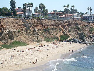
La Jolla is a hilly, seaside neighborhood in San Diego, California, occupying 7 miles (11 km) of curving coastline along the Pacific Ocean. The population reported in the 2010 census was 46,781. The climate is mild, with an average daily temperature of 70.5 °F (21.4 °C).

Mission Beach is a community built on a sandbar between the Pacific Ocean and Mission Bay. It is part of the city of San Diego, California.

Black's Beach is a secluded section of beach beneath the bluffs of Torrey Pines on the Pacific Ocean in La Jolla, a community of San Diego, California. It is officially part of Torrey Pines State Beach. The northern portion of Black's Beach is owned and managed by the California Department of Parks and Recreation, while the southern portion of the beach, officially known as Torrey Pines City Beach, is jointly owned by the City of San Diego and the state park, and managed by the City of San Diego. This distinction is important as Black's Beach is most known as a nude beach, a practice that is now prohibited in the southern portion managed by the City of San Diego.

Torrey Pines State Beach is a public beach in San Diego, California, located in a community of Torrey Pines, south of Del Mar and north of La Jolla. Coastal erosion from the adjacent Torrey Pines State Natural Reserve makes for a picturesque landscape.
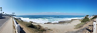
Windansea Beach is a stretch of coastline in the La Jolla community of San Diego, California. The neighborhood adjacent to the beach is named Windansea after the beach. It is named after the 1909 oceanfront Strand Hotel that was renamed "Windansea" Hotel in 1919 after the owner Arthur Snell ran a "naming contest". The Windansea Hotel which was located on Neptune Avenue between Playa del Sur and Playa del Norte burned down in 1943. Geographically, it is defined by the beachfront extending north of Palomar Avenue and south of Westbourne Street.
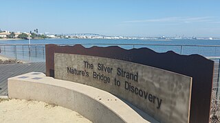
Silver Strand, or simply The Strand, is a low, narrow, sandy isthmus or a human-constructed tombolo 7 miles (11 km) long in San Diego County, California, partially within Silver Strand State Beach. It connects Coronado with Imperial Beach. Together with the Point Loma peninsula it shelters and defines San Diego Bay.
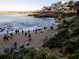
La Jolla Cove is a small cove with a beach that is surrounded by cliffs in La Jolla, a community of San Diego, California. Point La Jolla forms the south side of the cove. The area is protected as part of a marine reserve and is popular with snorkelers, swimmers and scuba divers.
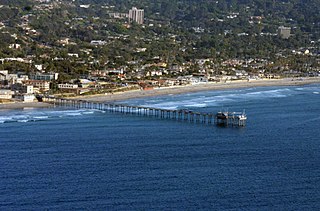
La Jolla Shores, with its northern part Scripps Beach, is a beach and vacation/residential community of the same name in the community of La Jolla in San Diego, California. The La Jolla Shores business district is a mixed-use village encircling Laureate Park on Avenida de la Playa in the village of La Jolla Shores.

Swami's is an area in San Diego County, California, that contains Swami's Beach and other local attractions. The beach, also known as "Swami’s Reef'" and "Swamis", is an internationally known surfing spot, a point break located in Encinitas. Swami's was named after Swami Paramahansa Yogananda, because the grounds and hermitage of the Self-Realization Fellowship ashram, built in 1937, overlook this reef point. The name "Swami's" is also given to the sand beach that extends south from the point to the next beach access point, which is next to the San Elijo State Beach camping area; this more southerly surf spot often goes by the name "Pipes".
The San Diego-La Jolla Underwater Park is the historical name for a marine reserve that includes the San Diego-Scripps Coastal Marine Conservation Area (SMCA) and Matlahuayl State Marine Reserve (SMR), adjoining marine protected areas that extend offshore from La Jolla in San Diego County on California's south coast.
Sunset Cliffs is an affluent coastal community in the Point Loma community of San Diego, California. It is bordered by the Pacific Ocean to the west, Ocean Beach to the north, Catalina Blvd. and Santa Barbara St. to the east, and Sunset Cliffs Natural Park to the south.

Marine Street Beach is a public beach in the community of La Jolla in San Diego, California, on the Pacific Ocean. It sits at the western terminus of Marine Street, with Children's Pool Beach to the north and Windansea Beach to the south. The surf has been described as rough and not suitable for children. However, the rough surf has made the beach popular with surfers and bodyboarders. Nearby kelp beds host marine life making the area a popular dive spot.

San Diego-Scripps Coastal Marine Conservation Area (SMCA) and Matlahuayl State Marine Reserve (SMR) are adjoining marine protected areas that extend offshore from La Jolla in San Diego County on California's south coast. The two marine protected areas cover 2.51 square miles (6.5 km2).
South La Jolla State Marine Conservation Area (SMCA) and South La Jolla State Marine Reserve (SMR) are two adjoining marine protected areas that extend offshore in San Diego County on California's south coast. The two marine protected areas cover 7.51 square miles (19.5 km2). The SMR protects marine life by prohibiting the removal of marine wildlife from within its borders, while the SMCA limits removal of marine wildlife.
Bird Rock is a seaside neighborhood within the larger community of La Jolla in San Diego, California. It lies on the Pacific Ocean at the southernmost end of La Jolla, just north of Pacific Beach. The mostly residential neighborhood includes homes for 1,400 to 1,500 families, with a commercial district along the main street, La Jolla Boulevard. The shore is rocky and has no beach, but offshore reefs are used for surfing.

This is a list of protests that took place in San Diego County, California, following the murder of George Floyd that took place on May 25, 2020 in Minneapolis, Minnesota, after police officer Derek Chauvin knelt on his neck for 9 minutes and 29 seconds. These events were created to fight for justice for George Floyd and other Black community members who suffer from police brutality. These demonstrations resulted in a number of policy changes, namely the ban of the cartoid neck restraints use in San Diego County and a city-wide independent review board that would review police practices.
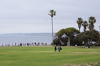
Ellen Browning Scripps Memorial Park, often referred to as Scripps Park, is an urban park in La Jolla, a community in San Diego, California. The park is sited on a sandstone bluff overlooking the Pacific Ocean. It is 5.6 acres (2.3 ha) and has approximately 1,500 ft (460 m) of shoreline and includes La Jolla Cove, Point La Jolla, Boomer Beach, and Shell Beach. The La Jolla Adult Recreation Center, three historic belvederes, and a pavilion are the only buildings in the park.

