
Aberdeen is the county seat of Monroe County, Mississippi, United States. As of the 2010 census, the population was 5,612.

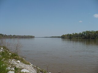
The Tombigbee River is a tributary of the Mobile River, approximately 200 mi (325 km) long, in the U.S. states of Mississippi and Alabama. Together with the Alabama, it merges to form the short Mobile River before the latter empties into Mobile Bay on the Gulf of Mexico. The Tombigbee watershed encompasses much of the rural coastal plain of western Alabama and northeastern Mississippi, flowing generally southward. The river provides one of the principal routes of commercial navigation in the southern United States, as it is navigable along much of its length through locks and connected in its upper reaches to the Tennessee River via the Tennessee-Tombigbee Waterway.

The Mobile River is located in southern Alabama in the United States. Formed out of the confluence of the Tombigbee and Alabama rivers, the approximately 45-mile-long (72 km) river drains an area of 44,000 square miles (110,000 km2) of Alabama, with a watershed extending into Mississippi, Georgia, and Tennessee. Its drainage basin is the fourth-largest of primary stream drainage basins entirely in the United States. The river has historically provided the principal navigational access for Alabama. Since construction of the Tennessee-Tombigbee Waterway, it also provides an alternative route into the Ohio River watershed.

Cotton Gin Port is a ghost town in Monroe County, Mississippi, United States.
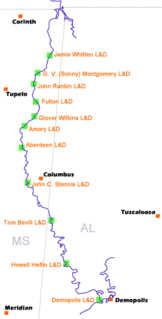
The Tennessee–Tombigbee Waterway is a 234-mile (377 km) man-made U.S. waterway built in the 20th century from the Tennessee River to the junction of the Black Warrior-Tombigbee River system near Demopolis, Alabama. The Tennessee–Tombigbee Waterway links commercial navigation from the nation's midsection to the Gulf of Mexico. The major features of the waterway are 234 miles (377 km) of navigation channels, a 175-foot-deep (53 m) cut between the watersheds of the Tombigbee and Tennessee rivers, and ten locks and dams. The locks are 9 by 110 by 600 feet, the same dimension as those on the Mississippi above Lock and Dam 26 at Alton, Illinois. Under construction for 12 years by the U.S. Army Corps of Engineers, the Tennessee–Tombigbee Waterway was completed in December 1984 at a total cost of nearly $2 billion.
Fort Stoddert, also known as Fort Stoddard, was a stockade fort in the Mississippi Territory, in what is today Alabama. It was located on a bluff of the Mobile River, near modern Mount Vernon, close to the confluence of the Tombigbee and Alabama Rivers. It served as the western terminus of the Federal Road which ran through Creek lands to Fort Wilkinson in Georgia. The fort, built in 1799, was named for Benjamin Stoddert, the secretary to the Continental Board of War during the American Revolution and Secretary of the Navy during the Quasi War. Fort Stoddert was built by the United States to keep the peace by preventing its own settlers in the Tombigbee District from attacking the Spanish in the Mobile District. It also served as a port of entry and was the site of a Court of Admiralty. While under the command of Captain Edmund P. Gaines, Aaron Burr was held as a prisoner at the fort after his arrest at McIntosh in 1807 for treason against the United States. In July 1813, General Ferdinand Claiborne brought the Mississippi Militia to Fort Stoddert as part of the Creek War. The 3rd Infantry Regiment was commanded by General Thomas Fluornoy to Fort Stoddert following the Fort Mims massacre. The site declined rapidly in importance after the capture of Mobile by the United States in 1813 and the establishment of the Mount Vernon Arsenal in 1828.
East Fork Tombigbee River was a historical name of a tributary stream of the Tombigbee River in northeast Mississippi. Its confluence with Town Creek in Monroe County was the historical beginning of the Tombigbee. Today, however, what was once known as the east fork is now designated as the Tombigbee.

The Aberdeen Lock and Dam is one of four lock and dam structures on the Tennessee-Tombigbee Waterway that generally lie along the original course of the Tombigbee River. It is located east of Aberdeen in Monroe County, Mississippi and impounds Aberdeen Lake.

The Yalobusha River is a river, 165 miles (266 km) long, in north-central Mississippi in the United States. It is a principal tributary of the Yazoo River, via which it is part of the watershed of the Mississippi River.

The Noxubee River (NAHKS-uh-bee) is a tributary of the Tombigbee River, about 90.6 miles (145.8 km) long, in east-central Mississippi and west-central Alabama in the United States. Via the Tombigbee, it is part of the watershed of the Mobile River, which flows to the Gulf of Mexico.
Bigbee is an unincorporated community in Monroe County, Mississippi.
Plymouth was an early settlement in Mississippi in present-day Lowndes County. Plymouth was located at 33°31′23″N88°30′06″W on the west bank of the Tombigbee River. It was formed around 1819, developing around the fortified house of John Pitchlynn, the U.S. interpreter for the Choctaw Agency. The low-lying site of the village was prone to repeated flooding. While both Plymouth and its sister town of Columbus across the river had high bluffs, Plymouth's landing site did not have easy access to the bluff heights. By the 1840s, the village site was abandoned, as most of the residents had moved across the river to the better site of Columbus.

Vienna is an unincorporated community about 6 miles from Mississippi in Pickens County, Alabama, United States. It was a prosperous river port from the 1830s until the American Civil War, situated along the eastern shore of the Tombigbee River on the southwestern border of the county. It declined rapidly in importance with the building of a railroad through Pickens County following the war. In 1917 the post office closed and this marked the end of Vienna's official status as a town.
Lauderdale is an unincorporated community and census-designated place (CDP) in Lauderdale County, Mississippi, United States. It is situated along U.S. Highway 45, 16 miles (26 km) northeast of Meridian, the county seat. The population of Lauderdale was 442 at the 2010 census.
Oak Slush Creek is a stream in the U.S. state of Mississippi. It is a tributary of the Tombigbee River.
Old Town was a Chickasaw village in northeast Mississippi in present-day Lee County.
Mooreville, sometimes misspelled as Mooresville, is an unincorporated community and census-designated place (CDP) in Lee County, Mississippi, United States. As of the 2010 census the population was 650. It was named for the Moore family, its first settlers.

Holcut was a small town located in Tishomingo County, Mississippi, United States. In 1976, the U.S. Army Corps of Engineers bought out and demolished the town because it lay in the path of the Divide Cut, a 29-mile (47 km) canal section of the Tennessee–Tombigbee Waterway, which was constructed between 1972 and 1984.
Bashi Creek, also historically known as Bashai Creek, is a tributary of the Tombigbee River in northern Clarke County in Alabama.
Kinterbish Creek is a stream in the U.S. states of Alabama and Mississippi. It is a tributary to the Tombigbee River.
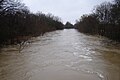 Town Creek at Brewer Rd under bankfull conditions Dec. 10 2008.
 Town Creek at 278 Rd (USGS station)under bankfull conditions (Dec 10 2008)
