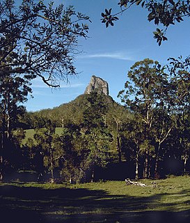
Glass House Mountains National Park is a heritage-listed national park at Glass House Mountains, Sunshine Coast Region, Queensland, Australia. It is also known as Beerburrum Forest Reserve 1. It is 70 km (43 mi) north of Brisbane and consists of a flat plain punctuated by rhyolite and trachyte volcanic plugs, the cores of extinct volcanoes that formed 27 million to 26 million years ago. The mountains would once have had pyroclastic exteriors, but these have eroded away.

Minerva Hills is a national park in Central Queensland, Australia, 626 km northwest of Brisbane. Lookouts within the national park overlook the town of Springsure. The park features a rugged landscape with volcanic peaks, sheltered gorges, sheer cliffs, open woodlands and dry rainforest.
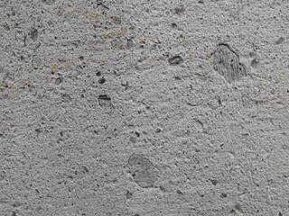
Trachyte is an extrusive igneous rock composed mostly of alkali feldspar. It is usually light-colored and fine-grained, with minor amounts of mafic minerals, and is formed by the rapid cooling of lava enriched with silica and alkali metals. It is the volcanic equivalent of syenite.

São Miguel Island, nicknamed "The Green Island", is the largest and most populous island in the Portuguese archipelago of the Azores. The island covers 760 km2 (290 sq mi) and has around 140,000 inhabitants, with 45,000 people residing in Ponta Delgada, the archipelago's largest city.
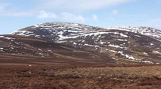
The Cheviot is the highest summit in the Cheviot Hills in the far north of England, only 1 1⁄4 miles from the Scottish border. An extinct volcano of the Caledonian period, it is the last major peak on the Pennine Way, if travelling from south to north, before the descent into Kirk Yetholm.

Monselice is a town and municipality (comune) located in northeastern Italy, in the Veneto region, in the province of Padua.
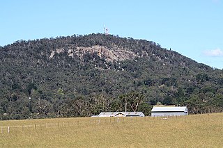
Mount Gibraltar is a mountain with an elevation of 863 metres (2,831 ft) AHD that is located in the Southern Highlands region, between Bowral and Mittagong, in New South Wales, Australia. Further west is Berrima.

The Itcha Range, also known as the Itchas, is a small isolated mountain range in the West-Central Interior of British Columbia, Canada. It is located 40 km (25 mi) northeast of the community of Anahim Lake. With a maximum elevation of 2,375 m (7,792 ft), it is the lowest of three mountain ranges on the Chilcotin Plateau extending east from the Coast Mountains. Two mountains are named in the Itcha Range; Mount Downton and Itcha Mountain. A large provincial park surrounds the Itcha Range and other features in its vicinity. More than 15 animal species are known to exist in the Itcha Range area, as well as a grassland community that is limited only to this location of British Columbia. The Itcha Range is within territory which has been occupied by aboriginal peoples for millennia. This area has a relatively dry environment compared to the Coast Mountains in the west.
Shell Glacier is a western lobe of the Mount Bird icecap. It descends steeply in the valley north of Trachyte Hill and Harrison Bluff in the center of the ice-free area on the lower western slopes of Mount Bird, Ross Island. Mapped and so named by the New Zealand Geological Survey Antarctic Expedition (NZGSAE), 1958–59, because of the marine shell content of the moraines.
Inclusion Hill is a prominent steeply conical hill, 335 metres (1,100 ft) high, between McDonald Beach and the Mount Bird icecap on Ross Island, Antarctica. It is a trachyte plug, in parts containing numerous inclusions of basalt. The hill was explored and descriptively named by the New Zealand Geological Survey Antarctic Expedition, 1958–59.

The Mount Edziza volcanic complex is a large and potentially active north-south trending complex volcano in Stikine Country, northwestern British Columbia, Canada, located 38 kilometres (24 mi) southeast of the small community of Telegraph Creek. It occupies the southeastern portion of the Tahltan Highland, an upland area of plateau and lower mountain ranges, lying east of the Boundary Ranges and south of the Inklin River, which is the east fork of the Taku River. As a volcanic complex, it consists of many types of volcanoes, including shield volcanoes, calderas, lava domes, stratovolcanoes, and cinder cones.
The Trachyte Hills are a small, hilly mountain range in southern British Columbia, Canada, located southwest of the junction of Bonaparte River and Hat Creek. They are a continuation northwards of the Cornwall Hills.
Trachyte Hill is a prominent hill, 470 m, just south of Shell Glacier in the center of the ice-free area on the lower west slopes of Mount Bird on Ross Island. Mapped and so named by the New Zealand Geological Survey Antarctic Expedition (NZGSAE), 1958–59, because of the rock type composing the hill.
Harrison Bluff is a pale-colored trachyte headland forming the seaward termination of Trachyte Hill and marking the southern end of McDonald Beach on the western side of Mount Bird, Ross Island, Antarctica. Many skuas nest on the bluff. A survey station marked by a rock cairn was placed on the top of the northwest corner of the bluff by E.B. Fitzgerald of the Cape Bird party of the New Zealand Geological Survey Antarctic Expedition, 1958–59, and the bluff was named by the New Zealand Antarctic Place-Names Committee for J. Harrison, mountaineer-assistant with the expedition.
Harrison Stream is a small stream flowing west between Trachyte Hill and Cinder Hill to the north end of Romanes Beach on Ross Island, Antarctica. It was mapped by the New Zealand Geological Survey Antarctic Expedition, 1958–59, and named by the New Zealand Antarctic Place-Names Committee for J. Harrison, mountaineer-assistant with the expedition.

Keratophyre is a volcanic rock of intermediate composition. Although similar to trachyte, keratophyre's plagioclase component is richer in sodium than the plagioclase found in trachyte. Keratophyre forms lava flows and subvolcanic intrusions. Keratophyre occurs, for example, at Hüttenrode in the Harz Mountains of Germany and in the Berwyn Hills of Wales. Keratophyre tuff of Early Devonian age occurs in Sauerland (Germany).
The geology of Saint Helena resulted from the long-running volcanic activity of the Saint Helena hotspot. Most of the island was formed beginning 14 million years ago. Volcanism on the island ceased seven million years ago, leading to long-running erosion and the formation of deep, v-shaped valleys along with steep coastal cliffs. Some geochemists have observed significant trace element variations between South Atlantic islands and proposed that deep-ocean sediments may have mixed into the magma which formed Saint Helena.

The geology of Ascension Island is the geologically young, exposed part of a large volcano, 80 kilometers west of the Mid-Atlantic Ridge. The island formed within the last six to seven million years and is primarily mafic rock with some felsic rock.

348-352 George Street, Sydney is a heritage-listed office building located at 348 - 352 George Street, in the Sydney central business district, in the City of Sydney local government area of New South Wales, Australia. It was designed by Edward Raht and built by Hudson and Loveridge. It is also known as the National Mutual Building (former), Society General Building, Societe Generale House, Equitable Building and 350 George Street, Sydney. The property is privately owned and was added to the New South Wales State Heritage Register on 2 April 1999.

354 George Street, Sydney is a heritage-listed retail and office building and former bank building located at 354 George Street, in the Sydney central business district, in the City of Sydney local government area of New South Wales, Australia. It was designed in various stages by Edward Raht, A. K. Henderson, Joseland & Gilling and Kevin Winterbottom and Assoc. and built in various stages from 1902 to 1937 by Loveridge & Hudson and Kell & Rigby. It is also known as ANZ Bank (former); ANZ Bank; United Permanent Building; 2 Martin Place; Paspaley Pearls; 354-360 George Street; and Bank of Australasia. The property is owned by Paspaley Pearls Properties P/L. It was added to the New South Wales State Heritage Register on 2 April 1999.