Related Research Articles

The Roan Cliffs are a series of desert mountains and cliffs in eastern Utah and western Colorado, in the western United States that are distinct from the Book Cliffs.

Kanab Creek is one of the many tributaries of the Colorado River. It begins in Kane County, Utah, just south of the watershed to the Great Basin and flows 125 miles (201 km) south to the Colorado River.

Calf Creek Falls refers to a pair of perennial waterfalls on the Calf Creek in the Grand Staircase–Escalante National Monument in central Garfield County, Utah, United States, that total 214 feet (65 m).
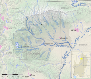
The Strawberry River is an 18-mile (29 km) river located in eastern Utah, United States.
Mammoth Creek is a creek in Iron and Garfield counties in southern Utah, United States, that flows for over 20 miles (32 km) through mountains and forests from Mammoth Summit, through the Mammoth Valley, to its confluence with the Sevier River. The creek contains wild brown trout and hatchery rainbow trout.
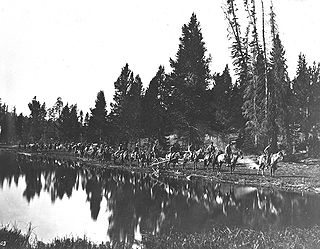
The Hayden Geological Survey of 1871 explored the region of northwestern Wyoming that later became Yellowstone National Park in 1872. It was led by geologist Ferdinand Vandeveer Hayden. The 1871 survey was not Hayden's first, but it was the first federally funded geological survey to explore and further document features in the region soon to become Yellowstone National Park, and played a prominent role in convincing the U.S. Congress to pass the legislation creating the park. In 1894, Nathaniel P. Langford, the first park superintendent and a member of the Washburn-Langford-Doane Expedition which explored the park in 1870, wrote this about the Hayden expedition:
We trace the creation of the park from the Folsom-Cook expedition of 1869 to the Washburn expedition of 1870, and thence to the Hayden expedition of 1871, Not to one of these expeditions more than to another do we owe the legislation which set apart this "pleasuring-ground for the benefit and enjoyment of the people"
Minnie Maud is the name of a creek and canyon in eastern Utah that is noted as the western starting point of the Ninemile Canyon petroglyphs section. Minnie Maud Creek is a stream whose headwaters begin where the West Tavaputs Plateau and Wasatch Plateau meet the Uinta Mountains.
Montezuma Creek is a tributary of the San Juan River. The stream is approximately 73 miles (117 km) long and is a seasonal river, becoming dry for several months of the year.
Browns Creek is a stream in Garfield County, Utah, United States.
Bullfrog Creek is a stream in Garfield County, Utah, United States.
Halls Creek is a stream in Garfield and Kane counties, in Utah, United States.

Laguña Creek also formerly also known as Tyende Creek, is a stream in the Navajo and Apache Counties of Arizona. Laguña Creek has its source at 36°41′15″N110°30′36″W, at the confluence of Long Canyon and Dowozhiebito Canyon at an elevation of 6,325 feet at the head of Tsegi Canyon. Its mouth is in the Chinle Valley at its confluence with Chinle Wash which together forms Chinle Creek, at an elevation of 4,774 feet. Chinle Creek is a tributary of San Juan River which is in turn a tributary of the Colorado River.

Chinle Creek is a tributary stream of the San Juan River in Apache County, Arizona and San Juan County, Utah. Its source is at 36°53′40″N109°44′37″W, the confluence of Laguña Creek and the Chinle Wash arroyo. Its name is derived from the Navajo word ch'inili meaning 'where the waters came out. Its sources is in Canyon de Chelly National Monument where Canyon de Chelly and Canyon del Muerto have their confluence at an elevation of 5,616 feet at 36°08′35″N109°29′17″W. It then trends northwest to its confluence with Laguña Creek where it forms Chinle Creek, 7 miles northeast of Dennehotso, Arizona at an elevation of 4,774 feet.
Mountain Meadow or Mountain Meadows, is an area in present-day Washington County, Utah. It was a place of rest and grazing used by pack trains and drovers, on the Old Spanish Trail and later Mormons, Forty-niners, mail riders, migrants and teamsters on the Mormon Road on their way overland between Utah and California.
Hamblin, now a ghost town, was a Mormon pioneer town along the Mormon Road, from 1856 to 1905. It was located at an elevation of 5,832 feet in Mountain Meadow in western Washington County, Utah, United States.
Fremont Wash sometimes called Fremont Canyon in its upper reach, is a stream and a valley in the north end of Parowan Valley, in Iron County, Utah. Its mouth lies at its confluence with Little Salt Lake at an elevation of 5,686 feet. Its head is found at 38°07′46″N112°34′36″W, the mouth of Fremont Canyon, an elevation of 6,476 feet.
Johnson Creek, originally known as Cottonwood Creek, is a stream in iron County, Utah, United States. Its mouth is in the Cedar Valley at an elevation of 5,407 feet (1,648 m), 1.5 miles (2.4 km) south of Rush Lake, where is dissipates into the ground. Its source is a group of springs, formerly known as Elkhorn Springs, later Johnson Springs, running from north to south, at the foot of the south end of the Red Hills at 37°46′32″N113°01′31″W at an elevation of 5,500 to 5,510 feet in what is now Enoch, Utah.

Ash Creek is a stream in northern Washington County, Utah, United States. It is a tributary of the Virgin River. Ash Creek was named after the ash timber near its course.
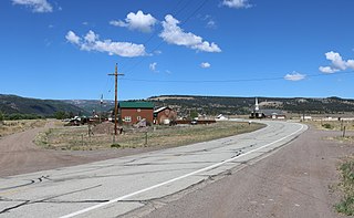
Fox Creek is an unincorporated community in Conejos County, in the U.S. state of Colorado.
Coal Creek is a stream in eastern Iron County, Utah, United States.
References
- ↑ U.S. Geological Survey Geographic Names Information System: Trachyte Creek
- ↑ Geological Survey Professional Paper. U.S. Government Printing Office. p. 24.
37°48′36″N110°27′24″W / 37.8099888°N 110.4565306°W
| | This article related to a river in Utah is a stub. You can help Wikipedia by expanding it. |