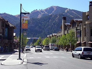
Ketchum is a city in Blaine County, Idaho, United States. Located in the central part of the state, the population was 3,555 at the 2020 census, up from 2,689 in 2010. Located in the Wood River Valley, Ketchum is adjacent to Sun Valley and the communities share many resources: both sit in the same valley beneath Bald Mountain, with its skiing. The city also draws tourists to its fishing, hiking, trail riding, tennis, shopping, art galleries, and more. The airport for Ketchum, Friedman Memorial Airport, is approximately 15 miles (24 km) south in Hailey.

Antelope Valley California Poppy Reserve is a state-protected reserve of California, United States, harboring the most consistent blooms of California poppies, the state flower. The reserve is located in the rural west side of Antelope Valley in northern Los Angeles County, 15 miles (24 km) west of Lancaster. To the north is Kern County. The reserve is at an elevation ranging from 2,600 to 3,000 feet above sea level, in the Mojave Desert climate zone. The reserve is administered by the California Department of Parks and Recreation. Other wildflowers within the reserve include the Owl's Clover, Lupine, Goldfields, Cream Cups and Coreopsis.

The Bighorn Mountains are a mountain range in northern Wyoming and southern Montana in the United States, forming a northwest-trending spur from the Rocky Mountains extending approximately 200 mi (320 km) northward on the Great Plains. They are separated from the Absaroka Range, which lie on the main branch of the Rockies to the west, by the Bighorn Basin. Much of the land is contained within the Bighorn National Forest.

Kananaskis Country is a multi-use area west of Calgary, Alberta, Canada in the foothills and front ranges of the Canadian Rockies. The area is named for the Kananaskis River, which was named by John Palliser in 1858 after a Cree acquaintance. Covering an area of approximately 4,000 km2 (1,500 sq mi), Kananaskis Country was formed by the Alberta Government in 1978 to provide an assortment of land uses and designations. Land uses include resource extraction activities, recreation, power generation, and residential communities. Land designations include public land and protected areas.

In agriculture, grazing is a method of animal husbandry whereby domestic livestock are allowed outdoors to free range and consume wild vegetations in order to convert the otherwise indigestible cellulose within grass and other forages into meat, milk, wool and other animal products, often on land that is unsuitable for arable farming.

John Day Fossil Beds National Monument is a U.S. national monument in Wheeler and Grant counties in east-central Oregon. Located within the John Day River basin and managed by the National Park Service, the park is known for its well-preserved layers of fossil plants and mammals that lived in the region between the late Eocene, about 45 million years ago, and the late Miocene, about 5 million years ago. The monument consists of three geographically separate units: Sheep Rock, Painted Hills, and Clarno.

Bitterroot National Forest comprises 1.587 million acres (6,423 km2) in west-central Montana and eastern Idaho of the United States. It is located primarily in Ravalli County, Montana, but also has acreage in Idaho County, Idaho (29.24%), and Missoula County, Montana (0.49%).

The Hells Canyon Wilderness is a wilderness area in the western United States, in Idaho and Oregon. Created 49 years ago in 1975, the Wilderness is managed by both the U.S. Bureau of Land Management and the U.S. Forest Service and contains some of the most spectacular sections of the Snake River as it winds its way through Hells Canyon, North America's deepest river gorge and one of the deepest gorges on Earth. The Oregon Wilderness Act of 1984 added additional acreage and currently the area protects a total area of 217,927 acres (88,192 ha). It lies entirely within the Hells Canyon National Recreation Area except for a small 946-acre (383 ha) plot in southeastern Wallowa County, Oregon which is administered by the Bureau of Land Management. The area that is administered by the Forest Service consists of portions of the Wallowa, Nez Perce, Payette, and Whitman National Forests.

Sawtooth National Forest is a National Forest that covers 2,110,408 acres in the U.S. states of Idaho and Utah. Managed by the U.S. Forest Service in the U.S. Department of Agriculture, it was originally named the Sawtooth Forest Reserve in a proclamation issued by President Theodore Roosevelt on May 29, 1905. On August 22, 1972, a portion of the forest was designated as the Sawtooth National Recreation Area (SNRA), which includes the Sawtooth, Cecil D. Andrus–White Clouds, and Hemingway–Boulders wilderness areas. The forest is managed as four units: the SNRA and the Fairfield, Ketchum, and Minidoka Ranger Districts.
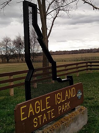
Eagle Island State Park is a public recreation area on the southwest outskirts of the city of Eagle, Idaho. The state park covers 545 acres (221 ha) that are bordered by the north and south channels of the Boise River. The park's recreational facilities include swimming beach, picnic area, equestrian trails, and a water slide.

The Almabtrieb is an annual event in the alpine regions in Europe, referring to a cattle drive that takes place in late September or early October.

A range war, also known as range conflict or cattle war, is a type of usually violent conflict, most commonly in the 19th and early 20th centuries in the American West. The subject of these conflicts was control of "open range", or range land freely used for cattle grazing, or conflicting sheep pasture, which gave these conflicts its name. Typically they were disputes over water rights, grazing rights, or cattle ownership.

Hells Canyon National Recreation Area is a United States national recreation area on the borders of the U.S. states of Oregon and Idaho. Managed by the U.S. Forest Service as part of the Wallowa-Whitman National Forest, the recreation area was established by Congress and signed by President Gerald Ford in late 1975 to protect the historic and archaeological values of the Hells Canyon area and the area of the Snake River between Hells Canyon Dam and the Oregon–Washington border.

Central Idaho is a geographical term for the region located northeast of Boise and southeast of Lewiston in the U.S. state of Idaho. It is dominated by federal lands administered by the United States Forest Service and the Bureau of Land Management. Idaho's tallest mountain, Borah Peak, is located in this region. A large part of the Sawtooth National Recreation Area is within Central Idaho.

The Seven Devils Mountains are notable peaks in the western United States, located in west central Idaho in the Hells Canyon Wilderness. They are above the east bank of the Snake River, which forms the Idaho-Oregon border.
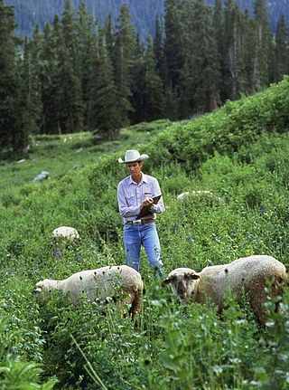
The U.S. Sheep Experiment Station (USSES) is an agricultural experiment station focusing on domestic sheep which is run by the United States Department of Agriculture's Agricultural Research Service. Its stated mission is "...to develop integrated methods for increasing production efficiency of sheep and to simultaneously improve the sustainability of rangeland ecosystems".
Lava Lake Land & Livestock is a lamb producer located between the Pioneer Mountains and Craters of the Moon National Monument and Preserve in South Central Idaho. The ranch consists of 24,000 acres (97 km2) of private land and over 900,000 acres (3,600 km2) of lands administered by the Bureau of Land Management (BLM), United States Forest Service, National Park Service, and the Idaho Department of Lands.
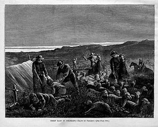
The sheep wars, or the sheep and cattle wars, were a series of armed conflicts in the Western United States fought between sheepmen and cattlemen over grazing rights. Sheep wars occurred in many western states, though they were most common in Texas, Arizona, and the border region of Wyoming and Colorado. Generally, the cattlemen saw the sheepherders as invaders who destroyed the public grazing lands, which they had to share on a first-come, first-served basis. Between 1870 and 1920, approximately 120 engagements occurred in eight states or territories. At least 54 men were killed and some 50,000 to over 100,000 sheep were slaughtered.

The Deep Creek murders were the culmination of a minor sheep war in the borderlands of Idaho and Nevada in 1896. On or about February 4, 1896, two Mormon sheepherders were killed by an unknown assailant while they were camping along a creek in what was then part of Cassia County, Idaho.

Drumlin Farm is a 291 acre farm and wildlife sanctuary which is also the site of the headquarters of the Massachusetts Audubon Society. It is located at 208 South Great Road in Lincoln, Massachusetts.
