Related Research Articles

The Stó꞉lō, alternately written as Sto꞉lo, Stó꞉lô, or Stó꞉lõ, historically as Staulo, Stalo or Stahlo, and historically known and commonly referred to in ethnographic literature as the Fraser River Indians or Lower Fraser Salish, are a group of First Nations peoples inhabiting the Fraser Valley and lower Fraser Canyon of British Columbia, Canada, part of the loose grouping of Coast Salish nations. Stó꞉lō is the Halqemeylem word for "river", so the Stó꞉lō are the river people. The first documented reference to these people as "the Stó꞉lō" occurs in Catholic Oblate missionary records from the 1880s. Prior to this, references were primarily to individual tribal groups such as Matsqui, Ts’elxweyeqw, or Sumas.

'Phra Lak Phra Ram' is the national epic of the Lao people, an adaptation of the ancient Indian epic Ramayana.
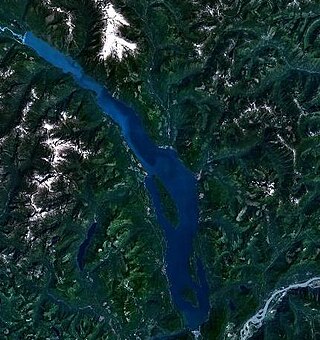
Harrison Lake is the largest lake in the southern Coast Mountains of Canada, being about 250 square kilometres (95 mi2) in area. It is about 60 km (37 mi) in length and at its widest almost 9 km (5.6 mi) across. Its southern end, at the resort community of Harrison Hot Springs, is c. 95 km east of downtown Vancouver. East of the lake are the Lillooet Ranges while to the west are the Douglas Ranges. The lake is the last of a series of large north–south glacial valleys tributary to the Fraser along its north bank east of Vancouver, British Columbia. The others to the west are the Chehalis, Stave, Alouette, Pitt, and Coquitlam Rivers. Harrison Lake is a natural lake, not man-made. The lake is supplied primarily from the Lillooet River, which flows into the lake at the northernmost point.

Quamichan is a traditional nation of the Coast Salish people, commonly referred to by the English adaptation of Quʼwutsun as the Cowichan Indians, or First Nations, of the Cowichan Valley on Vancouver Island, in the area near the city of Duncan, British Columbia and Salt Spring Island, British Columbia.

Lax-Kwʼalaams, previously called Port Simpson until 1986, is an Indigenous village community in British Columbia, Canada, not far from the city of Prince Rupert. It is located on Port Simpson Indian Reserve No. 1, which is shared with other residential communities of the Tsimshian Nation. The Nine Allied Tribes are: Gilutsʼaaw, Ginadoiks, Ginaxangiik, Gispaxloʼots, Gitando, Gitlaan, Gitsʼiis, Gitwilgyoots, and Gitzaxłaał.

Joe Capilano, also known as Capiano Joe, was a leader of the Squamish from 1895-1910, who called him Sa7plek (Sahp-luk). He fought for the recognition of native rights and lifestyle.
X̱wemelch'stn, usually anglicized as Homulchesan, is a large community within the Squamish Nation of the Squamish people, who are a part of the Coast Salish ethnic and linguistic group. The name X̱wemelch'stn, translates to "Fast Moving Water of Fish", relating to the Capilano River. The village is one of the oldest and major villages of the Squamish and continues to be so, being the Squamish Nation's most populated reserve. The community is also known as the Capilano Indian Reserve, formally Capilano Indian Reserve No. 5, and is named like the adjacent Capilano River after the Capilano chieftaincy, the best-known Joe Capilano. The name Kiapila'noq means "people of Kiap", and was the title of the supreme chief of the Sḵwx̱wú7mesh in the area of English Bay. Chief George Capilano was the chief who met Captain Vancouver at X̱wemelch'stn in 1792, and had met Captain Cook in 1782.
The Squamish people are an indigenous people of the Pacific Northwest Coast. Archaeological evidence shows they have lived in the area for more than a thousand years. In 2012, there was population of 3,893 band members registered with the Squamish Nation. Their language is the Squamish language or Sḵwx̱wúʔmesh snichim, considered a part of the Coast Salish languages, and is categorized as nearly extinct with just 10 fluent speakers as of 2010. The traditional territory is in the area now in southwestern British Columbia, Canada, and covers Point Grey as the southern border. From here, it continues northward to Roberts Creek on the Sunshine Coast, up the Howe Sound. The northern part includes the Squamish, Cheakamus, Elaho and Mamquam rivers. Up the Cheakamus River it includes land past Whistler, British Columbia. The southern and eastern part of their territory includes Indian Arm, along Burrard Inlet, through False Creek then English Bay and Point Grey. Today the Squamish people live mostly in seven communities, located in West Vancouver, North Vancouver, and within and nearby to the District of Squamish.
Ḵwiḵwa̱sut'inux̱w Ha̱xwa'mis, formerly the Kwicksutaineuk-ah-kwa-mish First Nation is a First Nations band government based on northern Vancouver Island in British Columbia, Canada, in the Queen Charlotte Strait region. It is a member of the Musgamagw Tsawataineuk Tribal Council, along with the ‘Namgis First Nation and the Tsawataineuk First Nation. The Kwikwasut'inuxw and Haxwa'mis are two of the many subgroups of the peoples known as Kwakwaka'wakw, which has two meanings: "smoke of the world" or "beach at the north side of the river."
The Wuikinuxv Nation, also known as the Oweekeno Nation, is a First Nations band government whose traditional territory is the shores of Rivers Inlet and Owikeno Lake in the Central Coast region of the Canadian province of British Columbia, in the area south of Bella Bella and north of Queen Charlotte Strait. The Wuikinuxv people a.k.a. the Oweekeno people reside in the area of Rivers Inlet and Owikeno Lake, primarily at a village on the Wannock River. Substantial numbers of Wuikinuxv also reside away from the traditional territory in Port Hardy on Vancouver Island and in larger BC communities such as Campbell River, Vancouver and Victoria. Approximately 80 people reside at the village while overall membership was 283 in 2006, 194 of whom lived off-reserve.
The WuikinuxvIPA:[ʔuwik'inuxʷ],, also rendered Oweekano (Pre-1976); Oowekeeno (1976-2003) are an Indigenous First Nations people of the Central Coast region of the Canadian province of British Columbia, located around Rivers Inlet and Owikeno Lake, to the north of Queen Charlotte Strait. The Wuikinuxv people and their neighbours the Heiltsuk and Haisla peoples were in the past sometimes known incorrectly as the "Northern Kwakiutl".

The Katzie First Nation or Katzie Nation is a First Nation whose traditional territory lies in the Lower Fraser Valley of British Columbia, Canada. According to their oral tradition, the Katzie people are the descendants of the Oe'lecten and Swaneset communities, two of five established by the Creator in present-day Greater Vancouver.
The Gitga'at First Nation is a Canadian First Nation, also known as the Hartley Bay First Nation. The members of the Gitga'at First Nation are often referred to as Gitka'a'ata. The population of Gitk’a’ata peoples living in Hartley Bay is approximately 140 as of November, 2024. There are also about 400-500 Gitk’a’ata peoples living in Prince Rupert, British Columbia, Canada, a neighboring territory. The Gitk’a’ata people have lived in Hartley Bay for hundreds of years, or longer. During the COVID-19 pandemic there were requirements for visiting Hartley Bay, such as vaccination status and British Columbian passport.
The Tlowitsis Nation, formerly the Klowitsis Tribe, the Turnour Island Band and the Tlowitsis-Mumtagila First Nation, is the Indian Act band government of the Ławit'sis (Tlowitsis) tribe of the Kwakwaka'wakw peoples, located in the Queen Charlotte Strait-Johnstone Strait area in the Discovery Islands between Vancouver Island and the British Columbia mainland in Canada. Ławit'sis territory covers parts of northern Vancouver Island, Johnstone Strait, and adjoining inlets of the mainland. Kalugwis, on Turnour Island, was their principal community in times past, but the band's offices are in the city of Campbell River to the southeast. Hanatsa IR No. 6 on Port Neville is the most populated of the band's Indian reserves.
The K'ómoks First Nation, is the Indigenous band government of the Island Comox or K'ómoks people of Vancouver Island, British Columbia, Canada. Closely allied to the Cape Mudge and Campbell River First Nations, historically they were a Coast Salish people since integrated into Kwakwaka'wakw society. Originally part of the Laich-kwil-tach Council of Chiefs, which is a treaty society, they are now negotiating independently in the BC Treaty Process. They remain a member government of the Kwakiutl District Council.

Cheslakee was a steamship that operated from 1910 to 1913 under the ownership of the Union Steamship Company of British Columbia. In 1913, the ship sank, killing seven people. This was the only accident involving a passenger fatality in the 70-year history (1889–1959) of the Union Steamship Company. Following the sinking Cheslakee was raised, reconstructed, and launched again under a different name.

The Nimpkish River is a river in northern Vancouver Island in British Columbia, Canada. It is the longest river on the Island, rising on the west slope of Mount Alston, flowing northwest into Nimpkish Lake and then north into the Broughton Strait at a point 8 km east of Port McNeill, just southwest of the town of Alert Bay on Cormorant Island.
Memkumlis or, officially Meem Quam Leese, Memkoomlish, Memqumlis, 'mimkumlis or Mi'mkwamlis, commonly known as Mamalilaculla, which is actually the name of the subgroup of the Kwakwaka'wakw whose home it is, is located on the west side of Village Island in the Johnstone Strait region of the Central Coast of British Columbia.
Whulk or xwalkw, meaning "(logs) place crossewise", was a Kwakwaka'wakw village at the mouth of the Nimpkish River on northern Vancouver Island, which was a place of origin for some of the groups comprising today's 'Namgis group of Kwakwaka'wakw, who now reside mostly at Yalis on Cormorant Island.
References
| | This article relating to a myth or legend from North America is a stub. You can help Wikipedia by expanding it. |