
Torch Lake Township is a civil township of Houghton County in the U.S. state of Michigan. As of the 2000 census, the township population was 1,860.

Allouez Township is a civil township of Keweenaw County in the U.S. state of Michigan. As of the 2000 census, the township population was 1,584.

Sherman Township is a civil township of Keweenaw County in the U.S. state of Michigan. As of the 2000 census, the population was 60.

The Keweenaw Peninsula is the northernmost part of Michigan's Upper Peninsula. It projects into Lake Superior and was the site of the first copper boom in the United States. As of the 2000 census, its population was roughly 43,200. Its major industries are now logging and tourism, as well as jobs related to Michigan Technological University and Finlandia University.
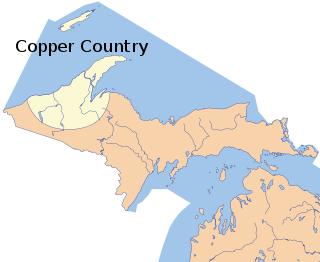
The Copper Country is an area in the Upper Peninsula of Michigan in the United States, including all of Keweenaw County, Michigan and most of Houghton, Baraga and Ontonagon counties as well as part of Marquette County. The area is so named as copper mining was prevalent there from 1845 until the late 1960s, with one mine continuing through 1995. In its heyday, the area was the world's greatest producer of copper.

The Keweenaw Waterway is a partly natural, partly artificial waterway which cuts across the Keweenaw Peninsula of Michigan; it separates Copper Island from the mainland. Parts of the waterway are variously known as the Keweenaw Waterway, Portage Canal, Portage Lake Canal, Portage River, Lily Pond, Torch Lake, and Portage Lake. The waterway connects to Lake Superior at its north and south entries, with sections known as Portage Lake and Torch Lake in between. The primary tributary to Portage Lake is the Sturgeon River.
Eagle River is an unincorporated community and census-designated place in the U.S. state of Michigan and is the county seat of Keweenaw County. Its population was 71 as of the 2010 census. It is by far the least-populated county seat in the state of Michigan.

Lake Duluth was a proglacial lake that formed in the Lake Superior drainage basin as the Laurentide ice sheet retreated. The oldest existing shorelines were formed after retreat from the Greatlakean advance, sometime around 11,000 years B.P. Lake Duluth formed at the western end of the Lake Superior basin. Lake Duluth overflowed south through outlets in Minnesota and Wisconsin at an elevation of around 331 m above sea level.
Delaware is an unincorporated community in Keweenaw County in the U.S. state of Michigan. It was established in 1846 as a copper mining town. It is located in the Keweenaw Peninsula, ten miles south of Copper Harbor and around twenty five miles north of Calumet. When the town was first settled it had a population of one hundred and rose to a population close to 1200 during full operation. When the town first started out the mining companies brought everything including housing, mining buildings, schools, grocery store, and a church. Today all that is left is a mining tour and foundations of old mining buildings. This is mostly because there were no other jobs and the location of the town is in a very remote location. The town made attempts to survive but in the end did not make it. The Bete Grise Light is located in the area.
The Little Misery River is a 7.0-mile-long (11.3 km) river on the Keweenaw Peninsula of the U.S. state of Michigan. It flows into the Misery River at 46°59′50″N88°58′52″W, shortly before it flows into Lake Superior.

The Pilgrim River is a 12.9-mile-long (20.8 km) river in Portage Township, Houghton County, Michigan, in the United States. The river flows near the Portage Lake Golf Course and empties into the Keweenaw Waterway, which connects to Lake Superior.
The Snake River is a 5.1-mile-long (8.2 km) tributary of the Portage River on the Upper Peninsula of Michigan in the United States. Via the Portage River, its water flows to Lake Superior.
The Trap Rock River is a 19.8-mile-long (31.9 km) tributary of Torch Lake that flows through Keweenaw and Houghton counties on the Upper Peninsula of Michigan in the United States.
The Silver River is a 3.2-mile-long (5.1 km) stream near the northern tip of the Keweenaw Peninsula in the U.S. state of Michigan. It rises out of a marsh around Bailey Pond at 47°26′16″N88°03′08″W and flows mostly northward into Lake Superior at 47°28′05″N88°04′26″W.

North Canal Township Park is a park across the Keweenaw Waterway from McLain State Park near Houghton, Michigan. It covers 177 acres and has several rustic campsites. The park features a breakwater which protects the Keweenaw Waterway. Stamp sand from old copper stamp mills to the southwest of the park have accumulated at the breaker and was recently restored to a more natural appearance by covering the sand with topsoil

Tamarack mine is a copper mine located in Osceola Township, Houghton County, north of Calumet, Michigan. The first shaft was started in 1882 and five shafts were eventually mined. In 1966 seven-year-old Ruth Ann Miller fell into shaft #4 and a rescue was impossible.

The Delaware Mine is located off U.S. Highway 41, 12 miles (19 km) in Grant Township, Keweenaw County, south of Copper Harbor, Michigan and is a Keweenaw Heritage Site. The Delaware Copper Mine provides tours of one of the oldest copper mines in the Keweenaw, dating back to 1846. The mine had five shafts, with the deepest reaching 1,400 feet (430 m). The mine is open June through October and offers guided and self-guided tours.
Cliff was a mining community in Michigan. It was located in Keweenaw County, Michigan and began in 1844. It remained a viable place past 1880.
The Wolverine Mine was a small copper mining operation in the Keweenaw Peninsula of Michigan, that was in operation from January 1882 until November 1884. In August 1890, possession of the company was obtained and reorganized as the Wolverine Copper Mining Company. It mined the Kearsarge lode until 1922 when it closed.


