Related Research Articles
The International Seabed Authority (ISA) is a Kingston, Jamaica-based intergovernmental body of 167 member states and the European Union established under the 1982 UN Convention on the Law of the Sea (UNCLOS) and its 1994 Agreement on Implementation. The ISA's dual mission is to authorize and control development of mineral related operations in the international seabed considered the "common heritage of all mankind" and also protect the ecosystem of the seabed, ocean floor and subsoil in "The Area" beyond national jurisdiction. The ISA is to safeguard the international deep sea, the waters below 200 meters or 656 feet, where photosynthesis is hampered by inadequate light. Governing approximately half of the total area of the world's oceans, the ISA is to exercise oversight of activities that might threaten biological diversity and harm the marine environment. The Authority operates as an autonomous international organization with its own Assembly, Council and Secretariat.
The United Nations Convention on the Law of the Sea (UNCLOS), also called the Law of the Sea Convention or the Law of the Sea Treaty, is an international agreement that establishes a legal framework for all marine and maritime activities. As of May 2023, 168 countries and the European Union are parties.

The terms international waters or transboundary waters apply where any of the following types of bodies of water transcend international boundaries: oceans, large marine ecosystems, enclosed or semi-enclosed regional seas and estuaries, rivers, lakes, groundwater systems (aquifers), and wetlands.

Territorial waters are informally an area of water where a sovereign state has jurisdiction, including internal waters, the territorial sea, the contiguous zone, the exclusive economic zone, and potentially the extended continental shelf. In a narrower sense, the term is often used as a synonym for the territorial sea.

Law of the sea is a body of international law governing the rights and duties of states in maritime environments. It concerns matters such as navigational rights, sea mineral claims, and coastal waters jurisdiction.

An exclusive economic zone (EEZ), as prescribed by the 1982 United Nations Convention on the Law of the Sea, is an area of the sea in which a sovereign state has exclusive rights regarding the exploration and use of marine resources, including energy production from water and wind. EEZ does not define the ownership of any maritime features within the EEZ.

The Svalbard Treaty recognises the sovereignty of Norway over the Arctic archipelago of Svalbard, at the time called Spitsbergen. The exercise of sovereignty is, however, subject to certain stipulations, and not all Norwegian law applies. The treaty restricts military uses of the archipelago, but it is not demilitarized. The signatories were given equal rights to engage in commercial activities on the islands. As of 2023, Norway and Russia make use of this right.
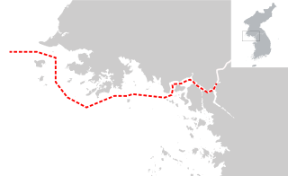
The Northern Limit Line or North Limit Line (NLL) – 북방한계선 – is a disputed maritime demarcation line in the Yellow (West) Sea between the Democratic People's Republic of Korea (DPRK) in the north, and the Republic of Korea (ROK) in the south. This line of military control acts as the de facto maritime boundary between North and South Korea.

Svalbard lies under the sovereignty of Norway, but the Svalbard Treaty places several restrictions. Norway cannot use the archipelago for warlike purposes, cannot discriminate economic activity based on nationality and is required to conserve the natural environment. Uniquely, Svalbard is an entirely visa-free zone. Everybody may live and work in Svalbard indefinitely regardless of country of citizenship. Svalbard Treaty grants treaty nationals equal right of abode as Norwegian nationals. Non-treaty nationals may live and work indefinitely visa-free as well. "Regulations concerning rejection and expulsion from Svalbard" is in force on non-discriminatory basis.
The Russo-Persian Treaty of Friendship was signed on 26 February 1921 in Moscow between representatives of Persia and Soviet Russia. Based on the terms of the treaty, all previous agreements made between the signatories including the Treaty of Turkmenchay were canceled. Moreover, both Russia and Iran were given full and equal shipping rights in the Caspian Sea along with the right to fly their respective national flags on their commercial vessels. Ratifications were exchanged in Teheran on 26 February 1922. It was registered in League of Nations Treaty Series on 7 June 1922. The original purpose of the treaty was to prevent White Russian counter-revolutionary forces who fled to Iran after the Bolshevik Revolution from attacking the Soviets from Iranian territory as had happened as late as 1918. The passage of the treaty, and particularly articles 5 and 6, was subject to vigorous debate in the Persian parliament; anti-British sentiment, however, lead to its acceptance without alteration. The treaty would serve as the basis for a Soviet occupation in 1941, and articles 5 and 6 were eventually repudiated by Iran in 1979.
The Treaty of Establishment, Commerce and Navigation was signed on August 25, 1935, between representatives of Iran and the Soviet Union. This accord helped to reinforce the tenets of the Russo-Persian Treaty of Friendship. Based on the terms of the treaty, both signatories reinforced their respective rights to fly their national flags on their respective commercial vessels. Moreover, both signatories were allowed to fish in the Caspian Sea within ten nautical miles (19 km) of the coastline.
The Arctic consists of land, internal waters, territorial seas, exclusive economic zones (EEZs) and international waters above the Arctic Circle. All land, internal waters, territorial seas and EEZs in the Arctic are under the jurisdiction of one of the eight Arctic coastal states: Canada, Denmark, Finland, Iceland, Norway, Russia, Sweden and the United States. International law regulates this area as with other portions of Earth.
The Convention on the Continental Shelf was an international treaty created to codify the rules of international law relating to continental shelves. The treaty, after entering into force 10 June 1964, established the rights of a sovereign state over the continental shelf surrounding it, if there be any. The treaty was one of three agreed upon at the first United Nations Convention on the Law of the Sea. It has since been superseded by a new agreement reached in 1982 at UNCLOS III.

As with other countries, New Zealand's 200 nautical miles exclusive economic zone gives its fishing industry special fishing rights. It covers 4.1 million square kilometres. This is the sixth largest zone in the world, and is fourteen times the land area of New Zealand.

The coastline of the Russian Federation is the fourth longest in the world after the coastlines of Canada, Greenland, and Indonesia. The Russian fishing industry has an exclusive economic zone (EEZ) of 7.6 million km2 including access to twelve seas in three oceans, together with the landlocked Caspian Sea and more than two million rivers.

The Marine Policy of the Barack Obama administration comprises several significant environmental policy decisions for the oceans made during his two terms in office from 2009 to 2017. By executive action, US President Barack Obama increased fourfold the amount of protected marine space in waters under United States control, setting a major precedent for global ocean conservation. Using the U.S. president's authority under the Antiquities Act of 1906, he expanded to 200 nautical miles the seaward limits of Papahānaumokuākea Marine National Monument in Hawaiʻi and the Pacific Remote Islands Marine National Monument around the U.S. island possessions in the Central Pacific. In the Atlantic, Obama created the Northeast Canyons and Seamounts Marine National Monument, the first marine monument in the U.S. exclusive economic zone (EEZ) in the Atlantic.
The Convention on the legal status of the Caspian Sea is a treaty signed in Aktau, Kazakhstan, on 12 August 2018 by the presidents of Russia, Kazakhstan, Azerbaijan, Iran and Turkmenistan.

Australia's exclusive economic zone (EEZ) was declared on 1 August 1994 and extends from 12 to 200 nautical miles from the coastline of Australia and its external territories, except where a maritime delimitation agreement exists with another state. To the 12 nautical-mile boundary is Australia's territorial waters. Australia has the third-largest exclusive economic zone, behind France and the United States but ahead of Russia, with the total area of 8,148,250 square kilometres (3,146,060 sq mi), which exceeds its land territory.

India has the 18th-largest exclusive economic zone (EEZ) with a total size of 2,305,143 km2 (890,021 sq mi). It includes the Lakshadweep island group in the Laccadive Sea off the southwestern coast of India and the Andaman and Nicobar Islands in the Bay of Bengal and the Andaman Sea. India's EEZ is bordered to the west by Pakistan, to the south by the Maldives and Sri Lanka and to the east by Bangladesh, Myanmar, Thailand, Malaysia and Indonesia. Based on new scientific data, India has petitioned United Nations to extend its EEZ from 200 Nautical miles to 500 miles.

The exclusive economic zone of Canada is the area of the sea in which Canada has special rights regarding the exploration and use of marine resources, as prescribed by the 1982 United Nations Convention on the Law of the Sea.
References
- ↑ Mehdiyoun, p. 180. The legal regime regarding the Caspian remained unchanged until after the Russian Revolution of 1917. The 1921 Treaty of Friendship between Iran and Russia abrogated all prior treaties and restored Iranian shipping rights in the Caspian. Under the Treaty of Establishment, Commerce and Navigation concluded by the two states on August 25, 1935, each party "reserv[ed] to vessels flying its own flag the right to fish in its coastal waters up to a limit of ten nautical miles." They reaffirmed the 10-mile fishing zone in the Treaty of Commerce and Navigation of March 25, 1940. Beyond the 10-mile zone, fishing was allowed only to Soviet and Iranian nationals. The Treaty was silent on seabed mining.